So I looked in FF and saw this
Those are not Jepp charts, they are AIP charts. It looks the same way for me, so it is probably an error in the database of the french AIP charting office.
For planning/familiarization I like the procedure feature:
https://youtube.com/watch?v=vLqdO9XKnak&feature=share
PS: Why does this airport need so many departure routes? Chicago O’Hare can do with less…
OK but I think a) you have worked out how to use binders (I fly trips on which I need this only every few weeks) and b) you have a Jepp sub (€ hundreds or more) and probably with that you get proper naming of the plates.
Since a few people at my home base use ForeFlight instead of SkyDemon, and Garmin avionics can receive flight plans directly from FF, I was interested and gave it another try since their Europe launch… Result: Now I value SkyDemon even more when flying VFR. I had some serious issues with the following (August 2023):
1. Finding the right frequencies. When you’re used to SD, this is a hell in FF. The only frequencies I found quickly were FIS and CTRs. But what about TMA and CTAs? Sometimes, there is none available, and sometimes 6 to choose from in tiny font size. Especially inflight, when it’s bumpy in the air, it’s a total nightmare. SD offers the radio tab and also displays frequencies on pop-up warnings. FF only tells me, when I’m about to enter a CTR or TMA, but not how I need to contact. Also, frequency callsigns are often wrong. There is for example no “Info” in Switzerland, except for Samedan… FF however adds “Info” to almost all radio callsigns.
2. Airspace overview and awareness. Keeping an eye on the airspace situation is one of the key things, while flying VFR. In FF with their vector charts, it’s extremely difficult. I had to activate the Swiss ICAO chart as overlay, in order to have some overview. In SD, airspace awareness is great with also a clear vertical view, if you press randomly on the map. In FF, there is no graphical vertical view, except when activating flightplan profile, which is only available for Pro Plus and higher subscribers. And their profile is not great compared to SD… sorry. And also in planning mode, there are no warnings or an clear overview which airspaces you plan to penetrate. SD has a dedicated tab for this!
3. NOTAM. Having said the bad awareness of airspace, it’s even worse for NOTAM’s, especially restricted areas that are only activated by NOTAM. Most restricted areas in Switzerland are only temporarily activated by DABS and/or NOTAM, which means that they’re no factor most of the time. In SD, there is a clear message at each LS-R when it’s activated or not. In FF, you don’t see it when you press on the LS-R. Yes, FF includes graphical NOTAM’s, but those for restricted areas are not added. It was pretty unclear to me which LS-R was activated when or not, so I had to cheat and looking in SD or DABS bulletin on Skybriefing.com. Also a list of NOTAM’s en-route are hidden and only available in the flight tab. SD has a dedicated NOTAM tab, where all relevant NOTAM’s for the planned route are directly available in both planning and flying mode.
4. Setup of airplane profiles. Extremely complicated, if you fly airplanes that aren’t available as templates. FF does not include the Robin DR401 CDI Version, so I had to do all configuration manually upfront. In SD, this works pretty quick and straightforward. Not so in FF… Also, full aircraft profiles are only available in the expensive Performance Plus subscription. Otherwise, you can only setup “basic” information. Serious FF?! SD offers all necessary profile settings within their default subscription, at the price of your Basic Plus subscription…
5. Outdaded Jeppesen information. Yes, Jeppesen Botlang is not always up to date with their information for VFR pilots. It is nice to have VAC charts in one single format across Europe, but I don’t trust Jeppesen alone. I found some errors at Buochs, so I would only trust original AIP information (and even AIP’s are not always guaranteed correct).
6. Creating and editing a route. In FF, you can’t just hold the magenta line and drop it at any city, mountain pass nor even ATS-waypoint. First of all, you need to select which ATS waypoint you want to add to the route in an extra pop-up. And when it comes to cities or mountain passes: You need to create a user waypoint first! WTF… SD can handle that with hold and drop automatically, and FF wants a user created waypoint?! This is a hell when navigating by towns and mountain passes around the Alps… There aren’t so much useful ATS-waypoints when flying around the Alps.
7. VFR Route Advisor. This tool is pure rubbish for VFR. They should deactivate it for VFR use. Routes make no sense and want me even to cross Zurich CTR outside of the mandatory reporting points, which doesn’t have any change for clearance. OK, SD doesn’t even have a route advisor tool, but EasyVFR for example does. It’s also not perfect, but at least more useful than the rubbish presented by FF.
8. Unrelevent airspaces / zones for VFR traffic. If you press somewhere on the map in FF to find airspace and frequency information, you get also a lot of rubbish presented like: “Free RT ASPC Skyguide Part1”, “Rhein UIR”, “EDGGBAD1 ACC”, “EDGGREU2 ACC”, ah and even “Bremen Tower” for “Airspace Class E” in Southern Germany. Really FF?!
9. FBO’s… Yes, FBO’s are a big thing in the US, but not in Europe and especially not in Switzerland. Why should I need to select a “FBO” for uncontrolled airfields in Switzerland in the flight planning tab? This is just the airfield itself…
10. Planned altitude. In SD, you can just drag and drop your planned altitude at the flight profile. Not so in FF, you need to select each single leg between two waypoints and type in manually. Gosh… this takes ages!
OK, OK… I did find also some good aspects of FF. Weather information is absolutely great and impressive compared to SD… But hey, nobody said that you can’t use tools like Windy or Meteoblue together with SD, with even more forecast options than FF. And METAR information in FF is sometimes confusing, especially when thunderstorms are reported. SD turns IMC when thunderstorms are reported in the METAR, FF continues reporting green “VFR” status. Not so great. The icon for VMC or IMC conditions is also small in FF, while it’s clearly visible in SD.
However, a great feature of FF are of course electronic checklists. This is something SD could easily implement, but they don’t want to. Also the integration of Jeppesen aerodrome and approach plates is not available in SD. To be fair, I criticized the actuality of Jeppesen charts, but would still like them to have in SD as well. However, no chance to have them anytime soon. Also many smaller aerodromes are not part of the Jeppesen Bottlang database, so there is still need to have an Avioportolano in Italy or a Swiss VFR Manual if you want complete information of each airfield. FF does offer Skyguide VFR manual or Avioportolano as additional add-ons as well, but it’s a bit sad that Jeppesen doesn’t offer those fields as well.
In addition to the great weather information and checklists, a core thing I like about FF is the functionality to submit planned flights to Garmin avionics. Also, the “Passenger” app is a nice to-have feature, so passengers can follow flight progress in-flight on their phones as well. Also the synthetic vision is extremely well done in FF, but in the end, the big dealbreaker for me are clear VFR (vector) charts, fast VFR planning and frequency information. This remains terrible in FF and therefore, I just can’t recommend FF for VFR use at all.
Another big downside of FF is their “Apple-only” regime. Yes, I’m an Apple-fan and own an iPhone, iPad and iMac… but I do also understand other people don’t like it. Just skipping the Android market is unbelievable for me. In the end, FF remains a clear US product.
“European pilots… meet ForeFlight.” … “and learn to love your current European EFB application!” 
SD can handle that with hold and drop automatically
I do that (“rubberbanding”) in FF all the time, never needed to create a user wpt for that.
Why should I need to select a “FBO” for uncontrolled airfields in Switzerland in the flight planning tab? This is just the airfield itself…
I don’t understand. What do you mean by selecting an FBO? Never had to do that.
I just tried and it took 30 seconds to create a profile for DR401 Ecoflyer. True, not an exhaustive performance set (just basic weights and one value for climb/cruise/descent respectively, but it does the trick and should be accurate enough).
Just skipping the Android market is unbelievable for me.
Which market? The tiny fraction of people who don’t use FF because they insist on using an Android device? It must make sense from FF’s perspective to stay single OS, otherwise an Android app would have been released years ago. Commercial aviation is where the revenue is, and these customers/companies will simply buy iPads anyway.
I think your points are valid and FF has shown to listen and improve with disproportionate (=good) efforts given the irrelevant" European VFR market.
I do think you could shift the critique viewpoint a little from
“this sucks for a pure vfr app” to
“which app is the one stop shop for most flying usecases from VFR to IFR, planning, filing, mass&balance, weather etc..”
Imagine someone writing a review expressing disappointment after flying IFR in the US using SkyDemon :)
SD might be better on a few selected areas flying VFR in Europe, but it’s always easy to be better by focusing on one single thing vs. doing a lot of things. In FF’s case, just the fact that it works worldwide brings a lot of complexities.
OK but I think a) you have worked out how to use binders (I fly trips on which I need this only every few weeks) and b) you have a Jepp sub (€ hundreds or more) and probably with that you get proper naming of the plates.
Binder works just as well with AIP charts
Jepp for Europe is indeed expensive. US is only 200 bucks, Europe almost 900. I wonder why?
Snoopy wrote:
Imagine someone writing a review expressing disappointment after flying IFR in the US using SkyDemon :)SkyDemon never presented themselves to the US market, nor do they try to be an IFR application. ForeFlight however performs aggressive marketing among European pilots these days, including using influencers on social media, and thinks they’re the best worldwide.
I do think you could shift the critique viewpoint a little from
“this sucks for a pure vfr app” to
“which app is the one stop shop for most flying usecases from VFR to IFR, planning, filing, mass&balance, weather etc..”
Well, I’m honest here…  My humble opinion is that FF currently still sucks for VFR usage in Europe. It’s the best short summarized way to describe it. Other SD alternatives don’t… I’ve also had experiences with EasyVFR, GarminPilot and AirNavPro. While I prefer SD, I won’t say these apps suck all… I also don’t say FF sucks in general, but it does for VFR usage in Europe. I wouldn’t say anything bad if they didn’t present themselves to the European VFR market, but they do… and even force their product to become a market leader here. I’m always open to new products and also to reconsider it after improvement… but I know quite a few German pilots, how still use SD for their VFR flights, while they use FF for IFR (professional) flying. Now I know why…
Snoopy wrote:
The tiny fraction of people who don’t use FF because they insist on using an Android device?I think quite a lot more pilots would consider trying FF if it was Android supported. Now you will have a big black number of people, who never consider it, since it isn’t available on Android.
Commercial aviation is where the revenue is, and these customers/companies will simply buy iPads anyway.Agreed, commercial aviation is for sure a completely other world.
I just tried and it took 30 seconds to create a profile for DR401 Ecoflyer.I came across that profile too, but it seems not correct. The template in SD however matches 99% to our CDI 155hp version. I only had to correct the empty weight and CoG.
I do that (“rubberbanding”) in FF all the time, never needed to create a user wpt for that.Maybe I’m doing something wrong? On my iPad, FF always popping up their “add to route” screen, before you can change the route. And there, I can either select an existing navigation aid (VOR, ATS-waypoint, NDB etc.), airfield, or user waypoint. SD let me just drop the route at any city or mountain pass, without any popup or user waypoint.
Looked in the the Departures and found that it looks like it BRUSC6R is on the RNAV Ray 30R SID. My assumption on the naming is due to the chart names themselves which feature multiple departures.
On the duplicates, I’m wondering if this might be due to data cycle cutover – are all your downloads up to date? My assumption is the old ones are downloaded, but not overwritten by the 2308 versions. Probably best to reach out to [email protected] if assistance is needed on this one.
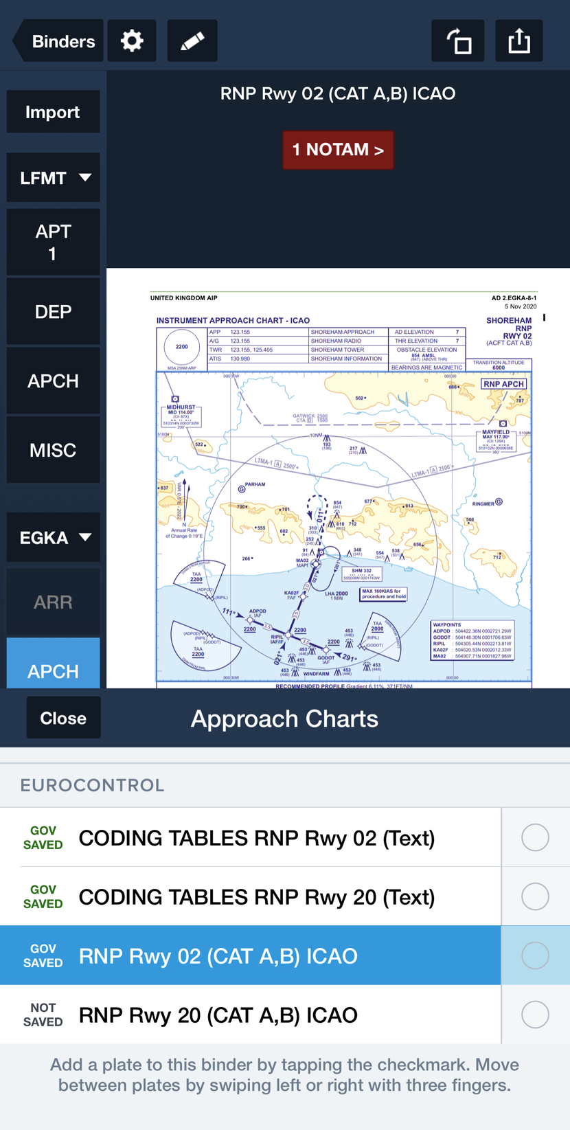
I updated the Ipad (8GB as usual) and now I see this

BRUSC6R is the 2nd from the bottom but you would not have got any clue to that. This is frankly an unworkable naming system. But it is how the AIP plates are named:

So the AIP plates are listed under names which make no sense relative to what ATC assign you. Totally mad, and I guess there is nothing FF can do about it.
As mentioned in a previous post, I am used to SD for my VFR flight and I am looking at moving to FF for VFR & IFR flying.
No doubt that for IFR FF is much better. For VFR I am still unsure.
I agree with @Frans thatSD seems much more easier to see the active zones and possible issue or upcoming airspaces/frequencies.
During my flight of this weekend I noticed in ForeFlight that the “hide airspace above 5000ft” – which I set during planning as I planned to fly below that- was still active in flight while flying at 6500 ft. Think this is quite strange. I would suggest to have it dynamic while in flight disregarding what has been set on the ground.
It is “dynamic” when in flight. Check your settings. There are different sliders for this.
AIP plates are stored in FF under their original names. In particular case the all RNAV departures from runway 30R are stored in file “RNAV Rwy 30R”. How hard is to find appropriate SID in this case?