On a recent trip I noticed a couple of things:
A click on an airport should open up a form listing things like approach charts. This doesn’t always work. For example, departing from EDNY, I could not get this feature to work. I wonder if it is zoom factor dependent?
It is worth noting that the regular FF data update can be huge. My last one was 7.5GB. You definitely want to do that at home, on an ADSL unlimited data package 
Peter wrote:
A click on an airport should open up a form listing things like approach charts.
You mean on the map or in the flightplan?
For charts, you can also go to the charts screen, then “import”, “from maps”, this will give you the departure and destination airport.
On the map.
I find “click on map” fiddly in ForeFlight and also on SkyDemon… Short click vs long click, and a few pixels makes a difference on what comes up…
Peter wrote:
A click on an airport should open up a form listing things like approach charts. This doesn’t always work. For example, departing from EDNY, I could not get this feature to work. I wonder if it is zoom factor dependent?
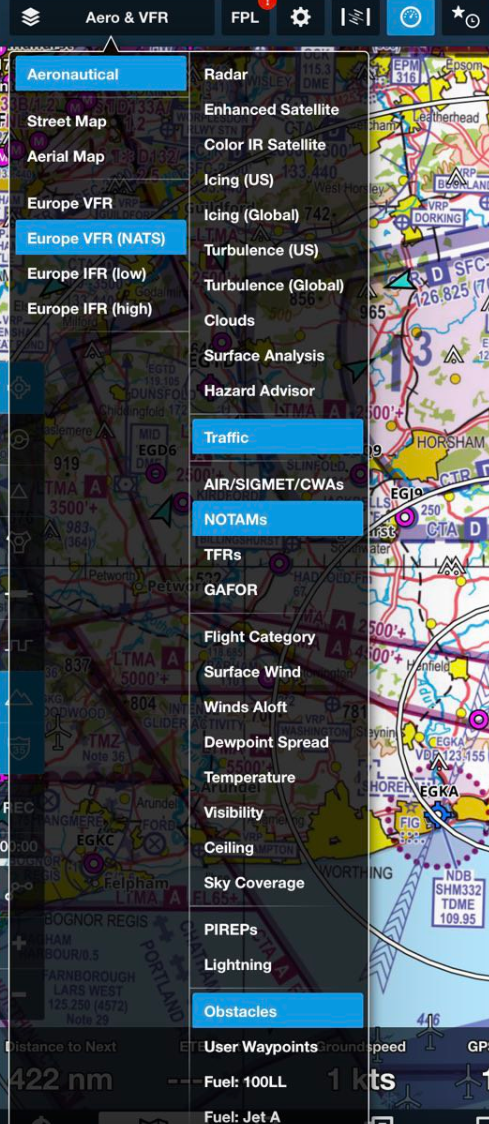
This feature uses the aeronautical layer and requires the aeronautical layer to be active. If you are viewing a raster chart and don’t also have the aeronautical layer on in the layer selector, tapping on an object such as an airport won’t bring up anything.
I like that VRPs are now properly supported, however there’s a caveat for people who synch flight plans with Garmin avionics. If you have a VRP in your plan the import to the panel will fail. It would be great if the data sent to the panel would be in the form of a user defined waypoint instead.
I always have the aero layer on. This is the config and I never change it
I always fly with printed charts for main and alternate. Infinite battery life, fully sunlight readable, and never shut down 
But unlike FF charts, they are not georeferenced.
If you have a VRP in your plan the import to the panel will fail.
I never had a problem with that. Transfer was fully functional the last weeks with the new VRP format. Before the update it was problem, but not in transfer only in the location of the waypoints.