
Ibra wrote:
Do you have the next METAR?
METAR EGHI 221050Z 10003KT CAVOK 05/03 Q1019=
METAR EGHI 221020Z 00000KT CAVOK 03/02 Q1019=
METAR EGHI 220950Z 00000KT CAVOK 02/01 Q1020=
METAR EGHI 220920Z 12001KT CAVOK M02/M02 Q1020=
METAR EGHI 220850Z 10001KT CAVOK M01/M02 Q1020=
METAR EGHI 220820Z 09002KT CAVOK M04/M04 Q1021=
METAR EGHI 220750Z 00000KT CAVOK M03/M04 Q1021=
METAR COR EGHI 220720Z 06002KT CAVOK M03/M04 Q1021=
METAR EGHI 220650Z VRB01KT CAVOK M03/M04 Q1020=
METAR EGHI 220620Z VRB01KT CAVOK M03/M03 Q1020=
METAR EGHH 221050Z 13012KT CAVOK 07/02 Q1018=
METAR EGHH 221020Z 11007KT 060V170 CAVOK 06/02 Q1018=
METAR EGHH 220950Z 13011KT CAVOK 06/01 Q1018=
METAR EGHH 220920Z 14009KT CAVOK 06/02 Q1019=
METAR EGHH 220850Z 13010KT CAVOK 06/02 Q1019=
METAR EGHH 220820Z 13010KT CAVOK 05/02 Q1019=
METAR EGHH 220750Z 13009KT CAVOK 05/02 Q1020=
METAR EGHH 220720Z 14010KT 9999 FEW018 05/02 Q1020=
METAR EGHH 220650Z 15008KT 110V180 8000 FEW017 05/02 Q1020=
METAR EGHH 220620Z 14009KT 7000 FEW017 02/00 Q1020=
Looks fog never materialised after 0820Z in both places? maybe some was in EGHH before 0620Z but did lift-off already by 0750Z? in EGHI it never materialised…
How does this work?
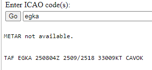
EGKA needs to issue two metars before the met office produces a taf – normally.
Nobody I know at EGKA seems to know the answer either, but I recall a past occassion when an AOC flight needed a TAF to be legal per its operating manual, and a sum of £££ was paid to the Met Office to produce one using some nearby METARs. The flight was billed for this, of course.
No idea how they handle it at EGKA but sure you can produce a TAF if sufficient information is available. In this day and age it is possible that they obtain what is necessary via automated stations nearby.
Occasionally it is done that TAFs can be produced by forecasters even for non metar airports.
And I have never ever heard of money involved in such stuff.
TAF EGKK 050457Z 0506/0612 VRB03KT CAVOK
TEMPO 0506/0507 1200 BR
PROB30 0506/0507 BKN003
BECMG 0507/0510 15010KT
PROB40 TEMPO 0512/0518 7000 SHRA
BECMG 0518/0521 VRB03KT
BECMG 0521/0524 8000
TEMPO 0600/0606 3000 BR
PROB40 0600/0606 0300 FG BKN000
BECMG 0606/0608 9999
PROB40
TEMPO 0608/0612 5000 RA SHRA
How is the SHRA in the bold section possible when no cloud is forecast for that period? Well, CAVOK is 5000ft AAL (or MSA if above 5000ft) but EGKK is almost at MSL.
It implies rain showers from cloudbase above 5000ft. In the UK, this is extremely unlikely.
Peter wrote:
How is the SHRA in the bold section possible when no cloud is forecast for that period? Well, CAVOK is 5000ft AAL (or MSA if above 5000ft) but EGKK is almost at MSL.
There is no requirement to include a change group in the TAF unless any cloud base drops below 1500 ft. (Or even 1000 ft if the number of VFR flights is insignificant.)
Really? That sounds wrong, it means that I would have to expect a possible1,500ft overcast even if CAVOK is forecast. That makes no sense and is not done that way anywhere.
I actually had a quick look at Chapter 3 Annex 5 and while it clearly says that changes in cloud ceiling (not base) should be reported if they pass through significant levels such as 1,500 ft as you write, I would interpret this as if there is a ceiling in the forecast in the first place, such as BKN020. Otherwise there is no change in the ceiling, but a new ceiling.
What is the difference between cloud ceiling and cloud base?
Peter wrote:
How is the SHRA in the bold section possible when no cloud is forecast for that period? Well, CAVOK is 5000ft AAL (or MSA if above 5000ft) but EGKK is almost at MSL.
The TAF at first describes the expected condition at the start of the forecast period.
0506/0612 VRB03KT CAVOK
Any change to that has to be above a certain threshold level. SHRA is a significant weather condition and requires a change group.
PROB40 TEMPO 0512/0518 7000 SHRA
Therefore implies that there is a 40% chance of SHRA out of cloud above 5000 ft or out of a cloud of less than BKN below that. Because a FEW or SCT cloud does not impact the ceiling, therefore there is no obligation to include it, even though it would make sense. But SHRA can very well fall out of a CU which is less than BKN.
There is a 2nd group which implies the same with even stranger phenomena RA SHRA. It should be either or, depending on the clouds they expect.
Peter wrote:
What is the difference between cloud ceiling and cloud base?
Cloud base is the height of the lowest cloud, ceiling is the height of the main cloud base of BKN or OVC. So in a group of FEW015 SCT030 BKN040, the ceiling would be considered to be 4000 ft AGL in a TAF or METAR, while the base would be partly at 1500 ft, partly at 3000 ft and outside those at 4000 ft.


