DavidC wrote:
the controller suggested I might try the ILS frequency of 110.9 which immediately lit up the glideslope indicators.
Sound like this was not the first time that happened since they immediately were able to suggest the right solution…
In any event I always believed in using the Jepp VFR+GPS charts for the sake of consistency from one country to another (too bad they’re gone). Likewise I find the national plates require too much getting used to, and in some cases unusable unless you have acquired the taste for them.
Thanks for sharing.
But isn’t also a shame that now we are all EASA that we can’t use the same format.
Must be a saftey case here
I would always load the procedure automatically and use the the navdata database to preset the frequency then verify it is correct.
All this EASA business for us to put up with, and yet when there is something such as approach plates where strict standardisation across Europe would provide a clear safety benefit and would be welcome by all, nothing is done and instead we have to pay a private company for a solution.
Jeppesen plates are definitely beneficial in Europe but the problem that I have is that flight apps such as Garmin Pilot render the national versions, which means you have to switch to Jepp’s own app at the approach phase of flight, and lose other features that your regular flight app might provide.
No such issues in the US where the national plates are always consistent, and pretty much as clear as Jepp anyway. And also available as a full set for a given area in a single handy booklet.
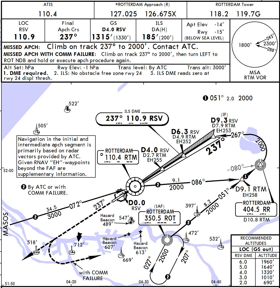
Great example and good post. I only read the first bit and went straight to the chart, and while it was easy to realise that the box pointed to a vor, not the ils – althoug being a bit forewarned probably helped – it took me quite a bit to find the ILS frequency and ident.
Compared to the jepp experience, where one can reliably brief and fly the approach without having seen the chart before the flight, this is really awful. I rarely study the approaches in detail – pre-flight familiarisation is more about understanding anything unusual and terrain considerations than finding the essentials in random places. The stress reduction and time saved is worth the money.
These national charts are mostly terrible. I once asked the UK CAA head of charts why they don’t do what the Americans do and publish them in an A5 size which is cockpit-usable, and his reply was that they are not in the business of competing with commercial providers [Jeppesen]. I thought this was outrageous and wonder what “arrangements” might be in place to facilitate the continuation of this situation. It cannot be to the advantage of any CAA to produce material which is so poor.
BTW here is the relevant bit of the Jepp chart
One thing to consider regarding most AIP plates they dont provide DA/MDA instead you get the OCA which is not the same thing. Minima are not provided either. So some homework is usually needed.
The MDA/DA on Jepp charts are usually not consistent with national regulation in my country (Denmark), except for ILS. So when I use Jepp pltes with its clearly stated MDA/DA, I still have to read the fine print in the national OPS regulation with all its tables and footnotes and definitions to work out what is legally correct. Of course I do that even when sitting in a dark cockpit in turbulence handflying and just been thrown a different approach from the one I have just briefed, anything else would be illegal … but I have noticed that if I had just concentrated on flying instead, and used the easily found Jepp minima, it seems I would have been safe every time.
mcrdriver wrote:
One thing to consider regarding most AIP plates they dont provide DA/MDA instead you get the OCA which is not the same thing. Minima are not provided either. So some homework is usually needed.
One keeps hearing that argument, especially from instructors/examiners who rarely have to pay for plates themselves or who only fly circles around their homebase and think a subscription for country X is bearable in cost. In reality this calculation is mostly absolutely trivial and while Jeppesen looks easy, their calculation is often not right so you are in violation but don’t even know it. In the above case we know that our limit is 200ft AGL but the chart gives 145ft AGL for Cat A which is 55ft below so 133ft + 55ft = 188ft MSL. As the airport is below MSL, this would be the lowest legal minimum in my history 
Sjoerd has published a free iOS app that performs the calculation for you, taking your operator limitations into account: http://www.aeroplus.nl/ifr-minima-on-state-plates
I personally can do well with the national charts and would not pay Jeppesen for the whole coverage I fly to.
This is a small error which was easily corrected and ended well.
I would never load a frequency manually if a system with a database is available. I have always been taught to use the database, and the check of validity is part of the pre flight checks/programming.
In the case of overlay and GNSS approaches of course it is mandatory to use the database, so why do anything different for an ILS?
I think this interesting story is a perfect example of why that is how it is usually done.
In the olden days before integrated nag systems one had to actually verify (ident) the nav aid.