Vladimir wrote:
I am considering flying IFR with SkyDemon and the charts it offers: from the AIP
boscomantico wrote:
The combination of autorouter and Skydemon is great.
I use it as well. It’s actually the one Tim recommends on the SD forums.
Vladimir wrote:
SkyDemon always shows the charts in portrait mode in the PDF viewer.
As SD merely reuses the pdf’s and position them, the plates are displayed in the orientation they are published. Take the STAR to EDDE, with runways 09/27 they are published in portrait, and displayed in portray too.
To switch from one orientation to the other, SD would need to recreate a fully vectorized file of each plate.
Vladimir wrote:
SkyDemon does not have the procedure points (SIDs and STARs) in its database.
When you have the georeferenced plates, you can draw the procedure, and rename the waypoints if needed.
At my home base, I have created permanent waypoints so they are always there.
Vladimir wrote:
The Swiss AIP charts for SIDs and STARs are not georeferenced either.
For some reason that seems to be airport-specific.
EDDE has georeferenced STARs but SIDs only as pdf.
EDVK has STARs behind a paywall but SIDs as pdf.
(I use these 2 airports as examples as I use them semi-regularly as fuel or overnight stops).
Vladimir wrote:
The procedure description is not available on the Swiss AIP charts either
For german airports they seem to be there. Not sure sure if it’s airport or country specific though, I have not checked every single airport.
Vladimir wrote:
The approach procedure charts do not have the morse code for the NAV aids, ILS, etc. for identification.
The morse code is on each Navaid (mouse-over on PC, long press on tablet).
Airport navaids with their morse code and frequency are at the bottom of the Pilot log. Route navaids will appear there if you include them explicitely in the route or if they are in an airway used for planning.
Vladimir wrote:
The approach procedure charts do not have the morse code for the NAV aids, ILS, etc. for identification.
Are there really pilots out there who don’t even know basic skills like morse? Just kidding. I learned it in the military (no, I’m not a hundred years old, it was in this century). Probably the only thing of practical use I learned there.
I wouldn’t be writing this had I not discovered just today (working on my IR) that there are even one or two related questions in the EASA QB because it is part of the syllabus.
No need to learn morse code; the proper plates show it
I find it a really handy double check that the right frequency has been set.
Peter wrote:
No need to learn morse code; the proper plates show it
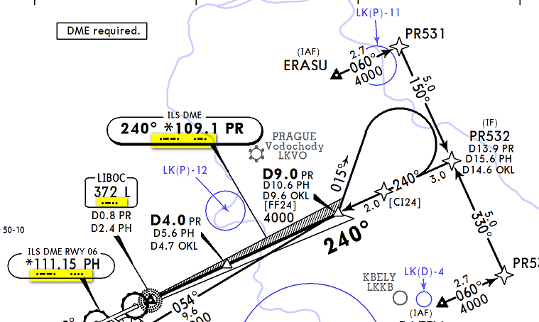
That’s exactly what’s missing on the Swiss AIP plates. Here is ILS 14 in LSZH:
Peter wrote:
I find it a really handy double check that the right frequency has been set.
According to my training and daily SOPs, that’s not “handy”, it’s mandatory. Of course, if you have G1000 or another modern FMS, it will do it for you, but if you are in an older airplane, you have to do it yourself by comparing it with the code on the chart.
This reminds me of a conversation with the then head of CAA charting. I asked him why doesn’t he publish terminal charts so they can be used in the cockpit. His reply was that the CAA is not in the business of competing with commercial providers!!!
The obvious conclusions from all this are
Re #1 it won’t be that simple. Years ago Jepp got sued by the Australian CAA for alleged breach of copyright. This was not unexpected. The action was settled out of court and no details ever leaked out. The CAA guy above said to me he was closely aware of the case but said no more. Fairly obviously a settlement was reached, involving multiple CAAs, which included a no-competition clause binding the national CAAs to producing the crap data we have. This is of course utterly scandalous and is why nobody talks about it.
Re #2, this is also very possible. There are few ex pilots in the CAAs. There are many ex-military types but in Europe the military don’t fly much, and the types who join the CAAs have probably not flown for decades. The UK CAA had a guy working there who wrote some really good and accurate flying book but soon he left for an airline job.
Vladimir wrote:
According to my training and daily SOPs, that’s not “handy”, it’s mandatory.
Not only to check that the correct frequency has been set, but also to check that the facility is working correctly. If it is transmitting but not operational, then the id signal will be turned off.
It is also possible that the same ILS frequency is used for both opposing runway ends (although I don’t know if that happens in Europe) and in that case checking the ID is the only reliable means of knowing that the correct transmitter is used.
Airborne_Again wrote:
It is also possible that the same ILS frequency is used for both opposing runway ends (although I don’t know if that happens in Europe) and in that case checking the ID is the only reliable means of knowing that the correct transmitter is used.
Southend EGMC, for example.
Vref wrote:
his is much more consistent better in Garmin Pilot.
On the other hand, Garmin Flitecharts is consistently late by one cycle when the charts change. See https://www.euroga.org/forums/flying/15222-garmin-flitecharts-outdated-information/
Vref wrote:
The GP route generator and autorouter are basically the same
Not “basically”, Garmin Pilot uses Autorouter, and pays for that.
Emir wrote:
However, I always wander who decided that it’s great idea to omit DME frequency from chart below (and from other Croatian AIP plates where DME is not colocated with VOR e.g. LSJ DME at LDLO), especially where this DME is primary navaid to check distance in localizer approach.
If you genuinely think it is a safety issue, then head to https://e2.aviationreporting.eu/reporting and report it. At least at the Luxembourg level, we were explicitly instructed by the head of the accident investigation authority to report systemic issues that we identify before they create accidents or incidents. Especially if you have a Croatian licence, your report will go to the Croatia authority, while e.g. mine would go to the Luxembourg authority and would be one step removed (the Luxembourg authority would have to forward it to the Croatian authority).
Please?
Vladimir wrote:
SkyDemon always shows the charts in portrait mode in the PDF viewer. I couldn’t find an option to rotate the chart, so it’s not comfortable to read it in flight. One option would be to download the PDF file (SkyDemon on PC or Autorouter) and open it in an alternative viewer.
As far as I remember (I didn’t renew my subscription last year), SkyDemon allows to export (“share”) the PDF to any PDF viewer. Or was that only on Android?