…oh, and a wider issue is the adoption of IFR by the GA community.
The difference is that in the US it is reasonable for a GA EFB supplier to spend as much on IFR capability as VFR because there is a 50% take-up of IRs.
But in Europe it is commercially viable to largely ignore the difficulties created by IFR, because 93% of the market is VFR only, hence Tim Dawson’s fairly staunch view on IFR capability.
Also, the considerable differences in VFR procedures not only between the US and Europe, but between European states, makes the challenges of developing a US product to compete with SD in the 93% VFR space rather great.
What we really need is for larger chunks of the GA community to embrace the CBIR and BIR and get into the safe, large empty spaces of the lower-middle airspace. Flight at 80-180 is just so safe and so easy!
And once we have that mixed VFR/IFR market, we are likely to see it better served by the commercial providers.
Piotr_Szut wrote:
I always have a paper Cartabossy http://www.cartabossy.com/ chart in my plane.
It’s an all in one VFR chart for France (and a part of Germany, Belgium etc.). Almost everything you need is on it: RH or LH circuit, description of the various zones, fuel availability, VFR transits and reporting points etc.
For readability E airspace is not shown.
It comes with a free very basic moving map app.
It’s probably the cheaper solution you can find.
I use it as a VFR in flight replanning aid. It can be also of assistance to find a VFR way through a complicated piece of airspace.
There is an excellent free android application (SDVFR) which can display the Cartabossy, purchased from their on-line boutique for 27.99 euros. You can also download most of the French charts with this application. It is in French, but is fairly intuitive. For those with iOS there is a paid version.
Simon
europaxs wrote:
SD seems to offer some IFR charts.
@Timothy wrote:
When I last looked at GP (some time ago) it didn’t support it standalone, but I assume that if you have Flightstream it presumably “inherits” the SIDs and STARs from the GTN, provided they are loaded there.
Unfortunately not yet.
GP can display AIP procedure charts with ownship position, but unlike a GNS/GTN the procedures are not shown as part of the magenta (or white or green) line on the moving map, even for a flight plan sent from the GTN. The best one can do to display a SID is this:
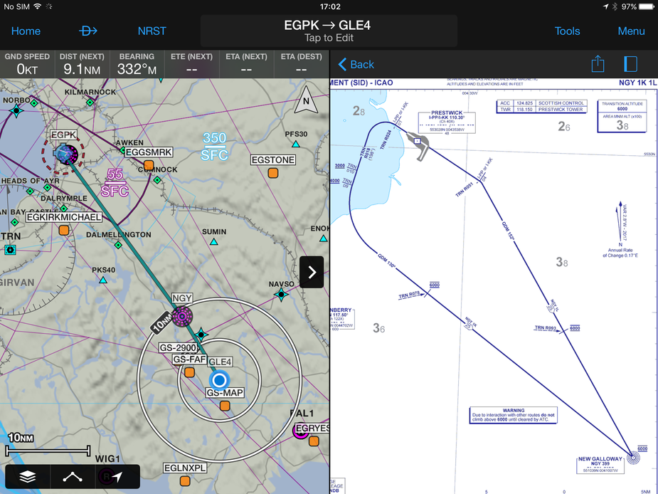
even though the SID is in the GP flight plan:

Approaches can’t be loaded into a GP flight plan, but the AIP plate can be displayed as a overlay with user-selected opacity, or split-screen as above. Again, loading the approach into a GTN and sending the flight plan to GP doesn’t help – GP still ignores the approach.
Afterthought: I’ll see whether RNAV approaches can be fed into GP from a GTN, since GP seems to display all the relevant waypoints.
Not sure if I am missing something but
Peter wrote:
AIP charts were never georeferenced (over the years, a few people looked at employing some very low cost labour to calibrate them and then QA check the result, but AFAIK nobody has)
The Garmin flitecharts are georeferenced for approaches. These are just the AIP charts.
Garmin must have put a lot of money into doing worldwide aip charts.
Interesting too politically wrt jepp doing all the panel mount charts.
Peter wrote:
Garmin must have put a lot of money into doing worldwide aip charts.Interesting too politically wrt jepp doing all the panel mount charts.
The Garmin charts can now also be loaded into an MFD. My G1000 uses them.
I keep it as a backup which is much cheaper than Jepp.