
I have even heard of the weather radar being used for terrain avoidance in the valleys, but that would definitely not be my cup of tea.
As to the legality, the general class E goes down to 2000 ft AGL over the Alps. If you flew in IMC in this controlled airspace without an IFR clearance, that wouldn’t be legal.
Peter wrote:
The 2016 Swiss ICAOVFR chart also shows no obvious CAS
I don’t get this, it also clearly shows a class E right around Samedan, from GND to 10000 ft?
Fly310 wrote:
In Sweden you could more or less take off from a VFR only strip(Class G airspace) in really bad weather.
Not more or less. You can.
Airborne_Again wrote:
Not more or less. You can.
Because almost everywhere you have class G up to FL95. In Switzerland, as in Germany, most of the airspace is class E or higher, and you only find uncontrolled airspace close to the ground in the few corners that have not yet been eaten up by some airports with CAT.
Shorrick_Mk2 wrote:
1000 fpm climb in the mountains is not a lot.
I respect that, but going up is better than going down. You are welcome to share some information on how you would operate in a situation like that.
Unless I were flying a jet I wouldn’t take off in less than a peak + 2000 ft ceiling on a windy day, or on anything below “Difficult” Gafor route on a no-wind day.
Thanks, I appreciate your advice!
the general class E goes down to 2000 ft AGL over the Alps
Does it dip down into the valleys too?
I have never seen a good answer to that Q but I guess if there is an airport in the valley then they will “dip” the CAS down over it…
This might be relevant.
it also clearly shows a class E right around Samedan, from GND to 10000 ft?
OK; I missed that  But the two charts differ. The Jepp one shows E from 2000ft AGL to 10000ft. The Swiss chart shows “something” from GND to 10000ft. However, E is not CAS for VFR, and you will be “VFR” if doing this in IMC, won’t you
  I am still talking about the departure clearance, BTW, but it looks like this is settled anyway (you will always get it).
The departure risks I see are icing, OEI on a ME, and navigation if your GPS loses reception due to terrain combined with a poor satellite geometry. I have met a pilot who told me he flies zero-zero approaches at night using the SR22 SV and this would probably not be an ideal place to do that.
Here is a picture from the briefing package. Looks like the airport is in G airspace and here you also see that it “dips down”.
Peter wrote:
OK; I missed that But the two charts differ. The Jepp one shows E from 2000ft AGL to 10000ft. The Swiss chart shows “something” from GND to 10000ft. However, E is not CAS for VFR, and you will be “VFR” if doing this in IMC, won’t you
I noticed the difference. Is that Jepp chart current? I thought they stopped making them 2 years ago or so. FWIW, my Skydemon also shows the Samedan FIZ from GND to 10’000 ft.
Since the question was about legality of an IFR departure through clouds, I think my answer is correct. The other question then is about risk and practicalities, but @Fly310 specifically stated he was less interested in that. For me personally, as I stated in the Annecy thread, I feel that IMC and high mountains don’t mix well at all.
Peter wrote:
Does it dip down into the valleys too?
Yes, it dips. It would indeed be interesting to have the exact definition of AGL, which I never found. Highest obstacle in a xx nm radius? Or what the last NASA mission measured as GPS altitude in the respective x by x square tile? Or what Swisstopo measured as ground height on their last geographical survey mission (the Alps still move upwards every year as you might know…) interpolated linearly?
I asked myself this question when flying under the immensely stupid Milan class A along the Alps in an easterly direction. In order to stay outside their class A, which was defined with respect to AGL (I think 1000 or 2000 AGL), you would not have been able to fly it with a C172 because it doesn’t have the dive/climb performance required to follow the terrain so closely. So I took a rather liberal interpretation of “AGL” overhead the valleys which must have been fine because you couldn’t even get radio contact with Milano.
But in any case, you don’t get around the fact the you will be inside class E before you are above the terrain surrounding the valley.
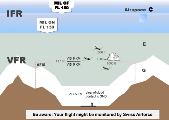
Fly310 wrote:
Here is a picture from the briefing package. Looks like the airport is in G airspace and here you also see that it “dips down”.
That is just a poster showing the general airspace structure in Switzerland, but they actually don’t claim that it depicts the situation at Samedan. They have class E around.
Peter wrote:
The Swiss chart shows “something” from GND to 10000ft.
The Swiss chart shows the Flight Information Zone. The FIZ has no bearing on airspace classification (between E and G).


