It serves as a confirmation in standard octos and is combined with the wind vector/angle and temperature. If it happens to fall inside the blue space, the information is less of course but better than spreading them out unevenly.
tomjnx wrote:
But not at the same altitude, the cloud density symbol is only for the altitude it is depicted at (700hPa pressure plane for the lowest circles)
I just looked at the GRAMET again. Do you mean 800 hPa rather than 700? It appears that the circles are drawn for the 800, 600, 400 and 200 hPa levels.
Another question… Are the levels of the circles chosen by you or are they somehow connected with the three levels of cloud that the GFS works with? I find the choice of levels unusual. Meteorological charts usually depict the 850, 700, 500 etc. hPa levels.
I would find it more useful if the GRAMET used the same levels as I could then cross-check the GRAMET data against “official” meteorological charts.
@Flyer59
30 seconds after TO I was IMC but I got an IFR clearance from Karlovy Vary Radar only one minute later, very nice
VFR in IMC!
After two years of blaming other peolple to do that, you do it by yourself? Now I´m scared and disappointed!
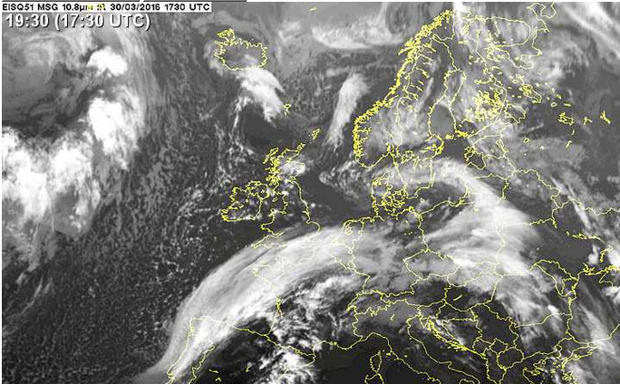
But nice documentation of the weather.
Well, did I really “blame other people”? I think I said i don’t do that, and now i did. I did it because I talked to the FIS guy in Prague who gave me a squawk and assured me that he would take care of me once i pop up on the radar. And, i admit it, it was a light case of “gethomeitis” too. I could have driven home in a S5004M … but really, I prefer the 40 minutes in the Cirrus :-)
Serious: Ok, I did read MANY posts about this issue, talked to many people, and I thought about it. I agree now that there’s occasions where it is okay to extend the limits a bit – especially when there is no risk involved.
I could also say: you all talked me into it ;-) Now, what do you want? ;-)
PS: I was really waiting for that comment. What really surprised me was that a) it took so long and b) it didn’t come from Achim :-)
@Flyer59
Achim looks quite offline at the moment. OK you change your mind about that “gap” big move at your age I admire that! I also change some limits down and up, it is always a compromise.
What I really try to do is to set my own limits and never do something just because “everybody does it”. In my 21 year flying carreer that always proved to be the right strategy. But in this case, the longer i thought about it the more I became aware that I have to make a compromise every now and then …
In this case it was clear: Fly through that cloud layer for 3 minutes – or drive for four hours, leave the plane at the field (i hate that ;-) ….
Ok, I’m planning a trip from EGKA to LOWS for tomorrow. Using Autorouter (which it think is fantastic), I get a particular cross-section of forecast weather. Using another source (RocketRoute) I get something significantly different. I’m predominately interested in icing. Thoughts?
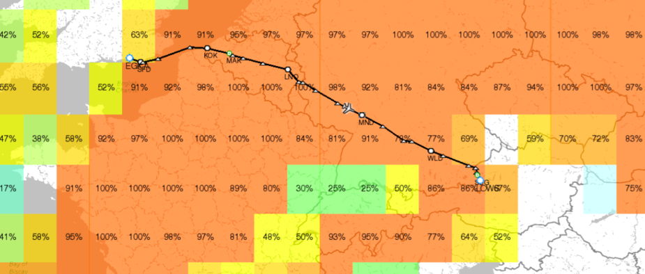

The Rocketroute icing forecasts are totally worthless. They exaggerate the icing risk by about 3000%, every time. 
Autorouter Gramet is sometimes a little bit too optimistic.
In fact, both forecasts above say roughly the sane. It’s just that RR always puts it a very pessimistic way.
Currently that stuff enroute has tops c. FL300 IMHO

Looking at the soundings
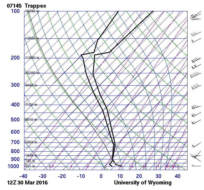
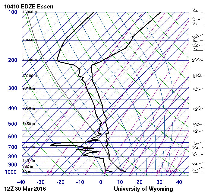

the temp and DP are close enough over much of it at FL100, so I would say icing yes but some of the route is likely to have not very thick IMC.
At FL100 I would expect to see -5C from the above so plenty of potential for ice
I would not do it in mine.
There is no such thing as an icing forecast  Well, not one that’s worth anything.
Also, GRAMET fails to forecast a lot of cloud. It isn’t a uniform 3D wx model. The GFS model separates clouds into low medium and high and often gets them totally wrong. Sometimes it gets them right and then everybody is happy…
I tend to agree. Interesting conundrum as VFR is not really an option and the lowest IFR route I can find is about FL070.
I guess I’ll be filling-up with TKS.