
I’ve updated the phrase giving “to not depart on the flight” as the third possible consequence 
I personally do consider BRS to be a mission profile extending feature of the Cirrus and if I had one, it would make me depart on flights that I might not do or do differently without BRS. YMMV.
Also note our disclaimer on GRAMET:
We live in a world where litigation has replaced common sense. Therefore here’s our disclaimer: DO NOT PLAN YOUR FLIGHTS BY RELYING ON OUR GRAMET. The forecast data could be totally wrong, our presentation of it could be totally wrong or whatever. If you fall from the sky because you departed on a flight that looked safe by looking at our GRAMET, then this is your problem, not ours.
Achimha
In fairness, I guess I do as well as I would be quite uncomfortable flying IMC at night without a BRS which is something that lots of people do without a second thought. That said, ice and mountains do rather scare me :)
BTW I think Gramet is a really useful planning resource!
The Cirrus CAPS system: I treat it as a second engine more or less. I prefer to fly the Cirrus at night than e.g. a single engine without a parachute system.
As for the weather: plan for an alternate in case you cannot land at your destination. If the alternate has an ILS and is a little ways away, you should be able to check the weather just before departure meaning also looking at the infrared cloudtop temp image, significant weather charts, the TAFs of (nearby) destination airports and the gramet / ogimet diagram. All together it should give you a good picture. Useless to make the go / no-go decision days ahead. Keep checking the weather but make the final call just before you go.
Ok After some trials and tribulations I finally landed at EDMA after doing a pattern at EDMS.
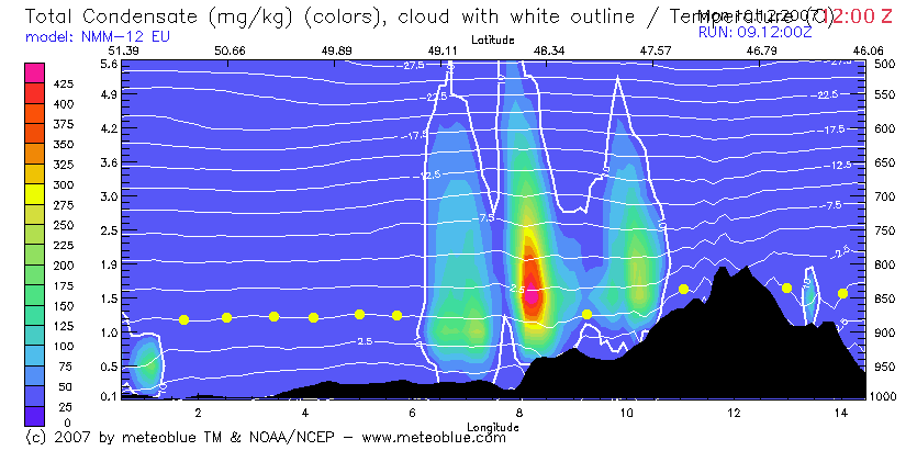
I departed LHTL it was sunny but there were some mid level clouds in the direction of my flight. According to Gramet there should only have been some higher broken clouds for the first 20% of the trip. It was a solid layer from 4-5000’ to about 9000’ Picked up ice at the tops smooth trace. The undercast lasted over most of W Hungary to about mid way through Austria after which it was clear. So on todays flight. Gramet was not too accurate.
After a great flight over Linz I was told that EDMA was closed due to an accident but would reopen in 1hr. Whats my Alternate? What were my intentions? The aiport should be open in 1 hr. I said I would go to EDMS but before I did that to call my ground transport to let her know whats up. In the mean time I slowed down and was given vectors in lieu of a race track hold. When the hour came and went with no further info I diverted to EDMS but before I would land asked them to call EDMA to get an update. Great 10minjs then would opened up. Broke off short final and went to EDMA.
What excitement.
The good news was the Frau never got all the in between messages.The only one she got was that Im on my way from EDMS. It turned out to be a good day after all.
It was a solid layer from 4-5000’ to about 9000’ Picked up ice at the tops smooth trace. The undercast lasted over most of W Hungary to about mid way through Austria after which it was clear. So on todays flight. Gramet was not too accurate.
Enroute TAFs would have given you that information. GFS (US global forecasting system) is not good at predicting low level stuff.
Also I humbly suggest to use autorouter’s GRAMET implementation. It generally provides a more realistic display of the expected cloud than OGIMET’s. I think that OGIMET both is too optimistic and there is also a bug in its implementation which sometimes hides clouds.
Also I humbly suggest to use autorouter’s GRAMET implementation.
In my case it has provided quite accurate forcasts – I’ve never seen much discrepancies between real weather and forecast.
Achim, what is the difference between the Gramet link I sent you and the one you are suggesting? The graphics look exactly the same?
I did look at the sat wx and it did suggest clouds most of the way. However Sat wx is a bit old. But when I see large areas under cloud cover dont really expect it to clear all up in a few hrs.
Two independent implementations, both using GFS data. Different algorithms/thresholds for clouds and — as I mentioned — what I believe to be a bug in OGIMET’s implementation. Also we draw it for your exact route/flight plan including level changes whereas OGIMET only knows the major airport codes. They came up with this presentation first (genius idea), we’re just the copycat here.
Satellite IR images are usually 15 minutes old, that is more than enough in my opinion. Widespread low stratus cloud is very typical winter weather for large parts of middle/eastern Europe. It is very difficult to predict. Often there is a very sharp line where that stratus cloud stops without any obvious reason (at least not obvious to me). GFS (the US NOAA model) is weak in that area. TAFs along the route are your best bet and of course a sat image together with METARs along the route taken just before the takeoff. autorouter does all that besides the sat IR image (copyright reasons).
They came up with this presentation first
Actually Meteoblue did, years ago, but they implemented only a straight line track, and used java client code which worked only on Mondays… the graphics were really pretty though
Widespread low stratus cloud is very typical winter weather for large parts of middle/eastern Europe. It is very difficult to predict. Often there is a very sharp line where that stratus cloud stops without any obvious reason (at least not obvious to me)
In a typical winter high pressure area (the above scenario) which is quite stable, the 0000Z/1200Z ascents are pretty good. The layer tends to be 1000-2000ft thick, with perfect blue sky above
The IR image can be had from here
Preparing my flight to the Prague meeting, I was grateful to use the Gramet generator
Plotting for April 30th, departing 7:20 UTC (random choice) from EBZH for EDBJ*, I soon saw the flight will not be feasible with lots of rain and even some snow around 3000 AMSL.
What escapes me is the colour of the “sky” at the end of the flight: where the rest of the picture shows the sky blue, deeper with increasing altitude, in the lower right corner it is very light blue, beginning with an abrupt vertical line, then more or less following terrain. Out of sheer curiosity: what does this different colour mean? I consulted the wiki but found no explanation, excuse me if I overlooked it.
I tried to post the image here, but drag-and-drop will apparently not work on a pdf.
*speed set was 80 knots, which I can only implement by flying close to Vne, but it wouldn’t go any lower.


