And my advice on the training flights is -
Get the aircraft slowed down a bit to give you more time.
You actually have more time than you think to set things up.
Even while setting up, keep coming back to your basic scan.
Real life "GA IFR using the full IR" is a lot easier than IR training because, at Eurocontrol levels, IMC means icing most of the year, so one actually spends most of the flight in VMC.
On my last trip to Greece which was 100% IFR, I logged something like 5-10 mins instrument time.
Thanks for all the good advice!
I take IR lessons in a PA28 without autopilot, and a simple task (like picking up a dropped ballpoint pen) becomes difficult when in IMC. I reckon that the training workload is much higher than it will be in real life. When flying IFR through Europe I won't do a NDB/DME RW05, then vectors for the ILS RW23, then a VOR/DME RW05, and when still flying the approach receive the outbound clearance and setting up the departure. All that without use of the GPS of course...
I was thinking that with organizing my stuff better, I could reduce some of the workload. But I think I must simply accept that this is what I have to deal with :-)
I keep an A5 kneepad like you have shown which contains my Jepp enroute charts and pencils. I have one piece of paper which is my plog (mainly there just to have a record of the flight plan route and to write other stuff on). I write ATIS and clearances on that along with a fuel summary which I mark off as I change tanks.
Everything else is on MFD with iPad as a backup. I don't carry paper approach plates. But for a test I would have them on the control column in roughly the right order.
I write down ATIS - Code, Rwy and QNH. Clearances - initial clearance on ground and maybe a major change in the air. Taxi - at an unfamiliar airport I would write down. Broadly if I can't easily read it back, I would write it down as that means I can't trust my memory.
I would always write down all clearances, including taxi clearances.
Same here - that's the only way you can be sure about full read-back.
I would always write down all clearances, including taxi clearances.
I know of people who claim to do this on an Ipad, with "finger writing", but I find that so tacky as to be almost unusable.
I also find myself writing down a lot less information than I used to. In the beginning, I had to fully concentrate to understand ATC information such as clearances, METARs and write them down, trying to hurry and not miss anything.
Nowadays, I rarely write down anything. Clearances en-route I can remember sufficiently well (stuff like direct XYZ, climb FL150 report passing FL100) and even the initial IFR clearance I usually do not write down because I have my flight plan open (on the iPad of course, no paper) and only write down what is different.
The most "difficult" information is usually "cleared to (some unknown five letter waypoint)". Trying to understand that waypoint and find it in the GPS, taking the ATC's local accent into account can be a challenge sometimes. What I really hate is when they refer to VORs by their full name, knowing that I'm a little GA airplane from abroad. The problem of trying to write down everything and then making sense is that you end up writing down something you won't understand and lose time so I don't write itdown but ask again until I can make sense of it and directly select in my GPS.
When asking about weather, you typically get the whole METAR after "report ready to copy" even though you just want to know whether it's OVC001 or FEW008 and I don't write down anything related to METARs or ATIS anymore, just fish out the relevant information and store that in my brain.
I'd also recommend an A4 kneeboard. On mine I have a small ring binder, which I keep any appropriate plates on, in plastic sleeves. They can fold easily out of the way, leaving you an A4 sheet so display a PLOG of your choice, and plenty of room to write information. I also have an iPad mounted on the yoke with Pooleys iPlates, SkyDemon and MemoryMap, but I too am not ready to dump the paper and the A4 kneeboard in favour of an all electronic setup.
I find I can get all the writing involved in the longest possible flight (7hrs+) onto an A5 sized area, easily.
The reason I use an A4 kneeboard is because I can clip all the other stuff to it - approach plates, enroute strip charts, etc. And it sits well on my knees.
Here is an old pic of my kneeboard
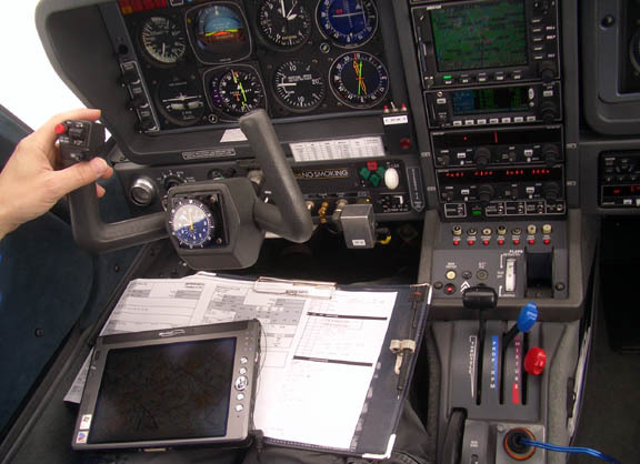
The plog sheet is actually A4 landscape, with the left 2/3 being the "traditional IR training" plog area which never gets used because I use a computer plog, which is what you actually see above. But potentially if I had to do a flight with no computer prep, that old plog might get used to write down the waypoints.
The LS800 tablet just runs VFR charts (important for emergencies under IFR too) and can be used for tafs/metars over the satphone. Most of the time is lives out of the way, running.
Paperless... not ready for that yet