For IFR, big jets have inertial navigation with DME/DME fixes. Most bizjets, and everything below, are 100% GPS and AFAIK (according to a Eurocontrol conference I went to in 2008) the plan is to have ATC offering vectors etc. I don’t think anyone is seriously suggesting going back to VORs because so many of the ones used as waypoints in IFR flight plans are too far to be actually received.
For VFR, I doubt anybody cares (or that there is any plan) so long as you don’t bust CAS and if you do they will bust you for that exactly as they would otherwise – because the official position is (and always will be) that you were trained to use the map, stopwatch, compass, etc and are flying visually  But seriously I think you would have to call up a radar unit for assistance, unless you are flying in an area where your position is blindingly obvious as in e.g. along the coast somewhere.
It is less of an issue in the airline world.
Light aircraft use single-sensor RNAV FMS for area navigation (that is what the Garmins include, from the humble GNS430 to the FMS part built into the GNSx000), and that location sensor is using GPS. The actual GPS/FMS unit may be redundant, but they tend to use one sensor at a time.
Airliners use multi-sensor FMS, which typically takes its location from a combination of an INS (inertial navigation system), DME/DME location fixes, and more recently, GPS. In case of a total GPS failure they will lose almost nothing. They can even fly RNAV approaches, as long as the RNP of the equipment without GPS is high enough.
Compared to that, the number of aircraft which have to revert to non-area navigation is low, and they will either use classic navaids or be given vectors.
A0356/18 NOTAMN
Q) LCCC/QGWXX/IV/NBO/E /000/999/3429N03246E180
A) LCCC B) 1803201004 C) PERM
E) RECENTLY, GPS SIGNAL INTERRUPTIONS HAVE BEEN REPORTED BY THE
PILOTS OF THE AIRCRAFT OPERATING WITHIN SOME PARTS OF NICOSIA FIR.
AIRCRAFT OPERATORS OPERATING WITHIN NICOSIA FIR ARE ADVISED TO
EXERCISE CAUTION.
Presumably Turkey toying with GPS in the region according to the news.
Chflyer
I guess when you phrase it that way it is true. It does appear that ‘only’ GPS approaches would have satisfied the flight test requirements.
When I did my Canadian IFR in 2015, I assure you I was required to demonstrate the use of traditional Navaids (NDB, VOR). It has been a while, but I am pretty sure that during the flight test I shot one ILS and one non-precision RNP (GPS without vertical guidance).
The examiner told me that for the ILS (or LPV) approach they want you to fly all the way down to the missed, just so that they can watch how accurate (and precise) your adjustments to the flight path are as the glide slope cone narrows.
It was also apparent that the examiner expected me to use the GPS for pretty much everything though (including as a cross check and magenta line for the NDB hold). That being said, it was minus 30 on my flight test day and the slaved mechanical HSI didn’t work too well (massive lag and had to be constantly reset). After a couple of turns in the NDB hold and all of the required HSI updating, the pragmatic examiner just told me that my ADF (plus HSI for heading) flying was fine and to just to go with the GPS!
I am not sure if all of the non-RNAV STARs have been withdrawn. A lot of SIDS and STARS are RNAV but I couldn’t say that they all are. However, the STARs terminate in a variety of approaches. For example all of the major airports have GPS or ILS approaches. Also some of the small airports will have a GPS approach and an NDB approach. I think that the the non RNAV STARs are retired as new procedures are implemented.
Victor Airways (based on VOR radials) are still widespread and in common use (although I am sure that GPS substitution of the VOR is standard practice).
Practically, in the present era I can’t imagine flying IFR in Canada without a GPS (certified), and a moving map (certified or not).
Thankfully, I don’t think that GPS jamming is that common in Canada :-). The big wide open empty space…
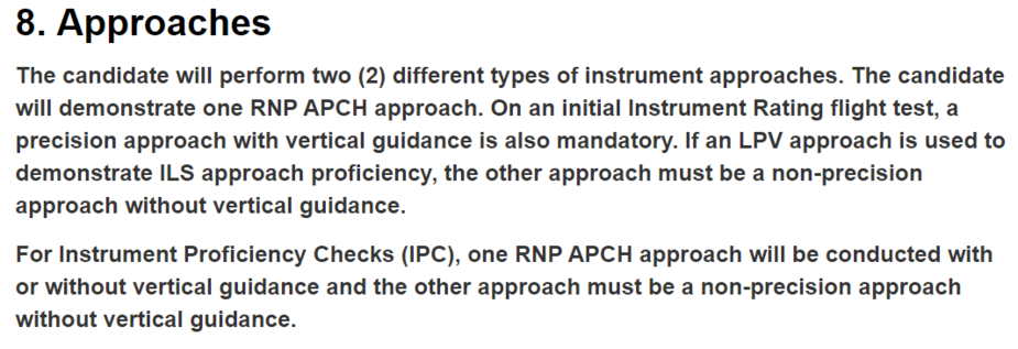
The flight test requirements are here.
LCCC NOTAM
A0356/18 – RECENTLY, GPS SIGNAL INTERRUPTIONS HAVE BEEN REPORTED BY THE
PILOTS OF THE AIRCRAFT OPERATING WITHIN SOME PARTS OF NICOSIA FIR.
AIRCRAFT OPERATORS OPERATING WITHIN NICOSIA FIR ARE ADVISED TO
EXERCISE CAUTION. 20 MAR 10:04 2018 UNTIL PERM. CREATED: 20 MAR 10:05 2018
No wonder with all the “vessels’” off shore down there and the Cyprus EEZ issue.
Turkey?
Who really needs GPS for LCCC FIR.
For Greece yes, but there is an old joke among Greek military pilots that they thank God about how Crete is geographical positioned.
For those they know :)
Yes; you would not want to end up over Libya by mistake 
Or over Turkey nowadays for that matter! This might be a serious problem given how close to Turkey one has to fly down there. Fortunately most GA planes can barely reach the Vs of an F16 so probably won’t get fired at
From here
Peter wrote:
Here’s something I never knew – my KLN94 needs to be scrapped immediately!
Why? GPS without WAAS capability has never been approved in the US for sole source of IFR navigation. It has always required the carriage of other means of navigation, aka VOR.
The note highlighted by Peter was with regards to primary, not sole source. I thought non-WAAS GPS was approved in the US for primary nav as long a another means remainded available, as you indicate. Is that wrong?
Perhaps a subtle difference, but still. After all, if not approved for primary nav even LNAV approaches would not be approved for non-WAAS GPS.