Airborne_Again wrote:
Do you have a reference?
Simply enter “Galileo changes frequency for USA” on Google.
The Wikipedia article has a good summary with references (see section “Tensions with the United States”)
https://en.wikipedia.org/wiki/Galileo_(satellite_navigation)
That is a typical anti American wiki writeup:
The rest of it is not much better. A typical anti American rant from Europe. But yes there is some good fun stuff in there, like the Galileo projection scam:
How will Galileo raise any money? Only by forcing the use of Galileo GPS positioning functionality in some specific context while banning the use of the US system, which seems quite bizzare.
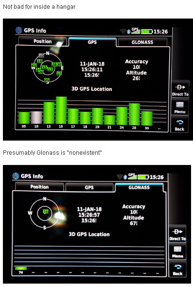
My Samsung S7 is US GPS only, AFAICS. Its spec says Glonass too but I see no evidence of it ever receiving the extra sats.
I have a Garmin GLO in both aircraft I operate. That has GLONASS for sure.
Sure; what I was getting at is: take your random local taxi driver and see what he uses. Then, better still, look at the crappy satnav in “your” car (crappy compared to Tomtom, Sygic, etc on a phone). Most of these won’t do Glonass.
I also think there is (or can be) something odd about Glonass reception on some devices which claim to support it – my own Aera 660 test posted here before
All the random local taxi drivers around here use a smartphone. It’s quite rare these days to see anyone using some non-smartphone satnav in these parts.
Also I’ve seen quite a few people ignore their car’s inbuilt satnav and just use a smartphone. This is usually because car satnavs generally have appalling user interfaces and lag far behind in useful functions compared to phone satnav apps, and are a pain (or even cost money) to keep up to date. Google Maps et al. just stays up to date without the user having to do anything.
The main reason I use Google Maps instead of my car’s inbuilt SatNav is that it is excellent at traffic. It’s so live as to be pretty much instantaneous. I have sat waiting for a hold-up (let’s say a garbage truck) which shows as red, stationary traffic, then, as the truck lets everyone by, the map changes to brown then no traffic. I find it beyond amazing how it reacts so fast.
But being up to date at no cost is important as well.
Well, it’s live because YOU are contributing your speed and position to it so it knows exactly how traffic is where YOU are. Which is fine of course, and works well as long as there are people contributing all along your route.
…a wonderful example of society contributing to its own good by working together.
Timothy wrote:
I have sat waiting for a hold-up (let’s say a garbage truck) which shows as red, stationary traffic, then, as the truck lets everyone by, the map changes to brown then no traffic. I find it beyond amazing how it reacts so fast.
I believe Android location services keeps it up to date, so as long as there enough Android phone users on the route, then Google Maps can update the traffic information pretty much instantly because they can see how fast (or not) Android phones are moving around the place.
Of course this all works only because Google charges businesses a few hundred quid a month and upwards to improve their rankings  And the data collected is sold, etc.
The element of mutually supportive social behaviour is precisely zero