NCYankee wrote:
If you purchase Jeppesen thru ForeFlight, then all three ForeFlight devices are included.
Ah OK, that is very good to know.
chflyer wrote:
Still learning ForeFlight. It is a feature-rich program and a good addition to the market, especially for mixed IFR/VFR flyers. Adds some choice. I now just need to figure out how to get the plates geo-referenced on top of my ForeFlight moving map.
I agree with what you say, it is heading in the right direction. They are throwing a lot of resources at Europe and it will be a good addition to the market. You send the plate to the map assuming it is georeferenced.
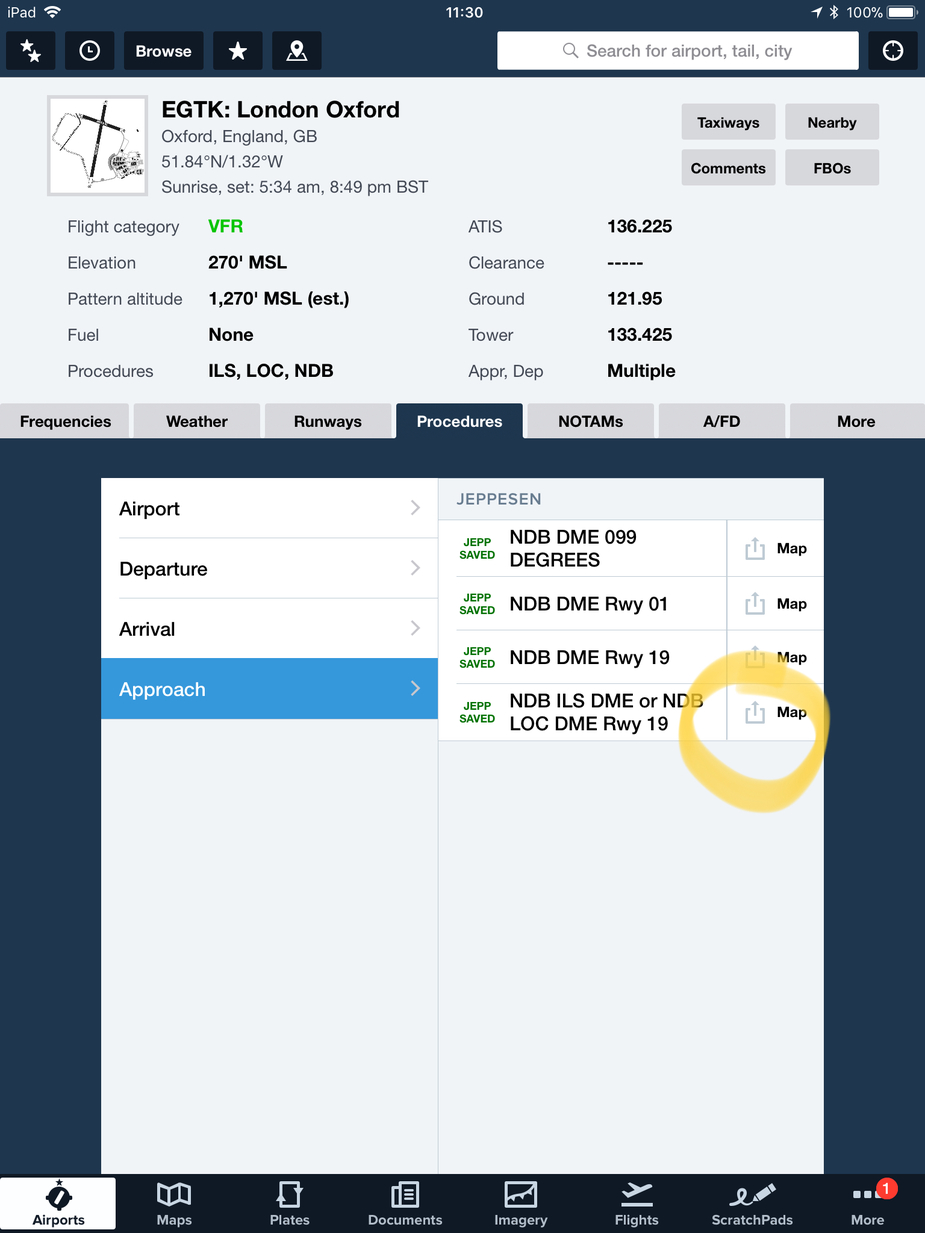
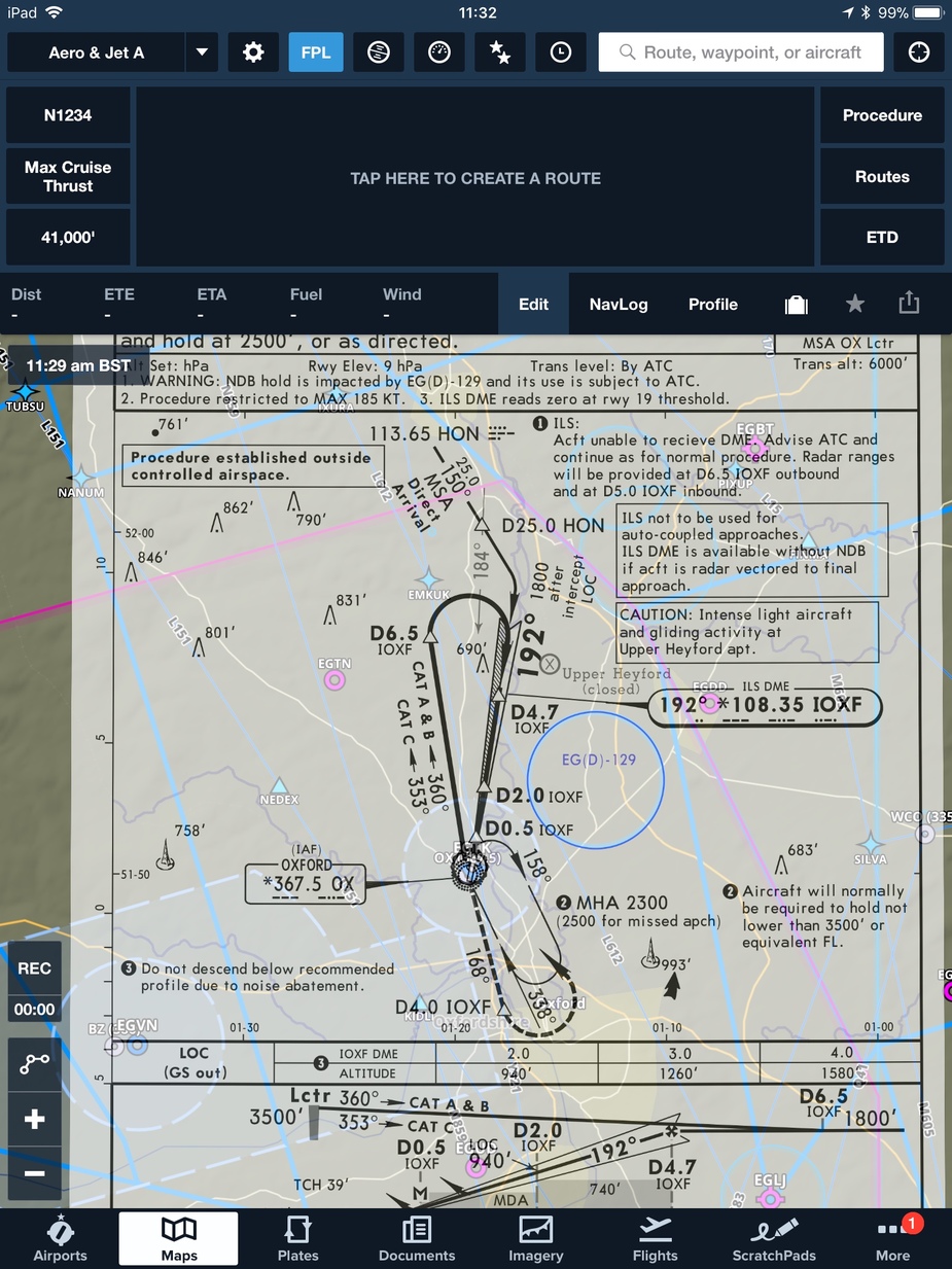
The georeferencing is available on the Map view and on the plates view. On the plates view, the ownship aircraft symbol will show on the plan view portion of the chart. On the map view, the transparency of the chart can be varied so one can see the underlying enroute charts and ownship is displayed on the map. The Jeppesen Low, Hi altitude IFR and VFR charts are not included in the current version, but should be available soon. Tapping on the chart in the Map view allows other approach charts to be selected and to change the transparency or hide the plate. In the plates view, one has a set of markup tools that allows the pilot to annotate the plate. I use this to edit the chart when there are NOTAMs. The procedure advisor allows the ARINC 424 description of the approach procedure to be included in the route.
The classical US solution to VFR mapping has always been very simple: take the free of charge sectionals, scan them (initially until the FAA started doing that) and pan them on the screen. Until today you can see the stitching marks in FF.
Achima, FF does not stitch around an image of a VFR chart in the US any more. That changed last year when they went over to fully vector based charts. Now you can zoom in very quickly and all the airspace is vector based overlays.
In my US trip, I used FF and it is spectacular.
But it was based on the free data given by the FAA.
If FF nows attacks Europe with Jepp data and good pricing (I saw 782$ for Europe IFR on FF website, and 100 more for IFR+VFR), I get concerned for skydemon ! Jepp data+FF ergonomics &software , that’s an unbeatable combination if well priced.
I also think about my future trips in the US 
Timothy wrote:
I am not a great fan of Garmin Pilot, but I do have a beautifully integrated Connext cockpit.Is there anyway to upload a GFP file from Autorouter to the GTN without using GP?
ForeFlight has the ability to upload flightplans to the Garmin GTN via one of the Flight Stream devices.
Foreflight isn’t quite there yet in Europe.
ForeFlight just released Version 9.4. It has added the Jeppesen Low and High enroute charts and the Jeppesen VFR charts.
What do the Jepp VFR charts look like for Europe?
Peter wrote:
What do the Jepp VFR charts look like for Europe?
Link with pictures and price: http://www.aviatorshop.eu/en/electronic-charts-and-flight-planning-software/1278-jeppesen-mobile-fd-vfr.html