
- and the plot thickens… From the online ICAO maps (which I haven’t looked at for years) it is clear that the whole mountainous area SE of ENVA is protected area for wildlife. hmm. To be honest I did know some of it was protected, but didn’t know exactly where, and didn’t know it was this large. SD have nothing of this info.
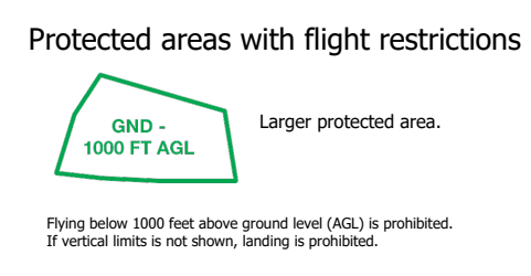
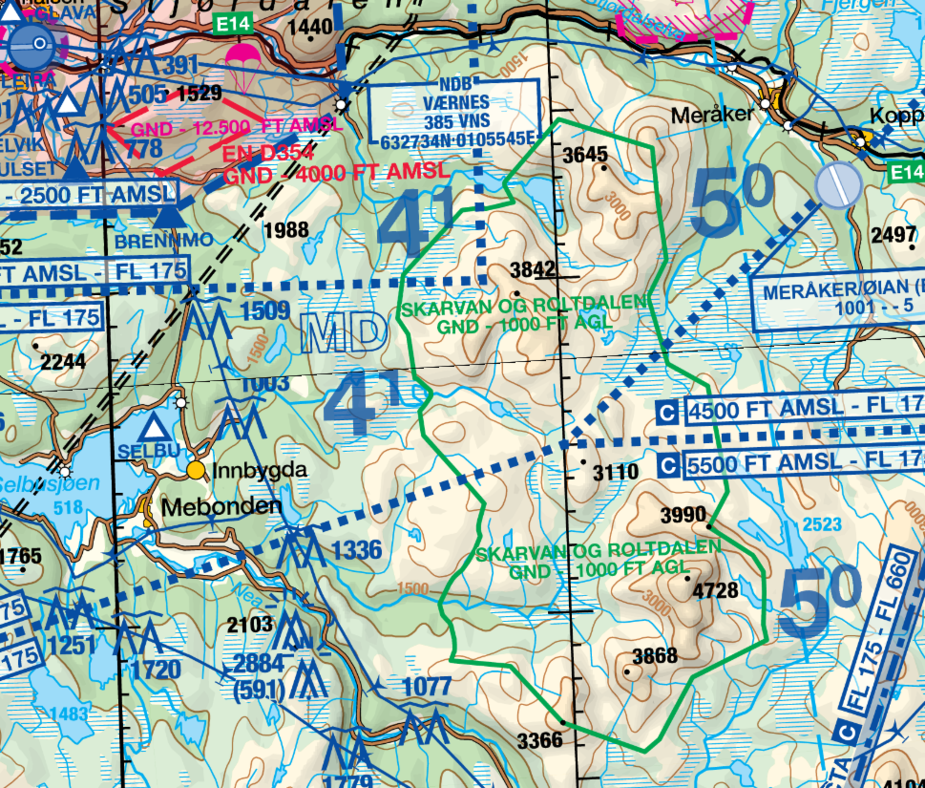
This means flying in the area has to be done 1000 ft AGL. 3500 feet – 1000 feet means all terrain above 2500 feet AGL is off limit to stay out of controlled airspace. It is still possible to fly there with 150-200 feet fudge factor, like this (red is into the TMA):
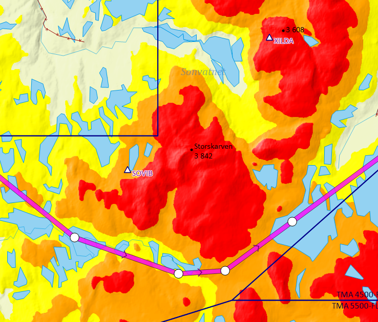
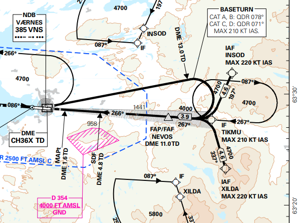
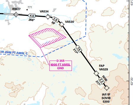
With a “fudge factor” of 500 feet up to the TMA, forget it. It wont work. Min alt is 1000 feet AGL. There are two IFR waypoints, XILDA and SOVIB. IFR also must fly 1000 feet AGL above terrain. This is the ILS approach. It use XILDA and min alt of 4700 feet:
There are several RNP approaches. The RNP E looks like this:
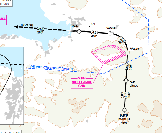
The RNP S is west of the whole protected area:
In Norway to be identified flying low over protected areas is really bad. The ATC couldn’t care less though, so the only way is to be photographed by some persons. Chances are that most people walking in those areas are as uninformed as the average GA pilot  To get caught you need to fly above the right person (or post stupid pictures on web sites… ) In terms of severity of “punishment” I would rank them as follows:
There are lots of things to look out for as a GA pilots. The usual tool (SD) won’t always help you. As a VFR pilot, the best way is to keep in contact with the approach under the TMAs if you are flying in Norway. Those protected areas is another matter though.
SkyDemon will only “parse” what is in AIP, are these “Protected Area” an ICAO standard or listed in Norway AIP?
For example in France, “no photography zones” are in IGN map but not in SkyDemon map as they are not in AIP…
LeSving wrote:
TMAs in a hilly country like Norway for sure must be difficult or impossible when obeying that 700 feet limit everywhere.
Yes, if MSL is used as reference for the lower limit, but if AGL is used, then it is dead easy!
I guess if AGL is used for TMA it will still get managed using some MVA s***shows on AMSL with QNH (and OAT corrections) or entry/exit via published routes and waypoints? any idea how Norway ATC handles pop-up IFR/VFR into that TMA?
Obviously, one can’t fly with -500ft/-1000ft on QFE or AGL for very long
Airborne_Again wrote:
Yes, if MSL is used as reference for the lower limit, but if AGL is used, then it is dead easy!
What do you mean? The planes have to get down IFR somehow, and that can only be done in a controlled airspace with proper separation from ground (mountain tops) and airplanes in G (unless you are Widerøe ) It seems like those RNPs are much easier on the airspace requirements than ILS though.
Ibra wrote:
SkyDemon will only “parse” what is in AIP, are these “Protected Area” an ICAO standard or listed in Norway AIP?
I don’t know, but they are in the ICAO map, which is part of the AIP, I guess? The information is definitely “out there” and available for free from AVINOR.
There is no such thing as the “ICAO VFR map” 
Any area that is not described using coordinates & altitudes or plain language in AIP ENR does not legally exist: aviation regulators & pilots will not be aware, sometimes ignorance is bliss !
This is very common for many “prohibited noise sensitive areas”, no one know about as no one bothers to publish them in the AIP…
Ibra wrote:
Any area that is not described using coordinates & altitudes or plain language in AIP ENR does not legally exist: aviation regulators & pilots will not be aware, sometimes ignorance is bliss !
The point here is that you aren’t breaking any “laws of the air” (or perhaps you are?). With these protected areas you are breaking the laws about nature, which is a different set of regulations altogether. I think SERA or Part NCO (or wherever it is) only say that you shall have adequate maps for the trip or something like that. SD or other similar software is considered adequate in this respect. However, AVINOR do produce and distribute (for free) everything you need, and this include detailed information about these protected areas. They are in their 500k ICAO maps. From an overall legal point of view, there really is no way you can get away with it saying that SD don’t show any of it. These areas are mentioned in the AIP along with the more stricter nature reservations, which perhaps exists also in SD?
It’s a bit like claiming innocence when stealing the wallet of your passenger because SERA don’t state that this is illegal, and the AIP has no mention of it
SD will get you and your passenger safe from A to B, legally (if all goes well) according to the laws of the air. SD, or similar, will not protect you from unknowingly flying illegally in protected areas. The thing is though, the basic data and maps from AVINOR will, and it’s all listed in the AIP. This is the difference. The “official” data is official. It has a higher level of quality of the data itself. Being official it also offer more protection if you end up in a legal dispute. SD is 100x more practical and easier to use, but the data could be all garbage or lacking. It’s good for “situational awareness” as they say
LeSving wrote:
What do you mean?
I mean that if the lower limit of a control area is expressed as a height above ground, then it is easy to avoid the situation you described where the lower limit gets below the minimum VFR altitude.
Of course the very best thing from a pilot’s perspective is to have a lower limit expressed as an altitude above MSL which also does not get below the minimum VFR altitude. But that’s more difficult to achieve in hilly/mountainous terrain unless you have lots of sectors with different lower limit which also is not good from a pilot’s perspective.
Airborne_Again wrote:
I mean that if the lower limit of a control area is expressed as a height above ground, then it is easy to avoid the situation you described where the lower limit gets below the minimum VFR altitude.
Not sure I get that either The problem is in knowing where and how to fly in mountainous areas close to larger airports. By using any of the usual apps, you won’t get any wiser, except if that app uses the official ICAO 500k map, which some do I understand (then it’s not a problem). SD is, hands down, the best app out there, but not in all respects, not in quality of data.
Funny thing though. On my M517 map from 2018, that area is also depicted in the same way as in the ICAO map. However, there that area is marked “LDG”, which means landing is prohibited, but AGL is the usual (500 feet). That 1000 feet AGL must have come later. Those M517 (250k) maps has red letters printed on the bottom saying “For military use only”, but they are the best. If only someone could make an app out of them
It’s a bit like claiming innocence when stealing the wallet of your passenger because SERA don’t state that this is illegal, and the AIP has no mention of it
That is what I meant, if you bust that zone you will have to deal with Owner or local Police not the local CAA


