
^ we dont have a “like” on here, but I like and agree with the above^^^
Personally I find having a moving map traffic and airspace display an absolute Godsend in terms of avoiding distraction in complex, busy airspace. Using ATC in my area means listening to and understanding an endless stream of conversion, most of which has nothing to do with me, to make sure I do hear and respond to anything ATC has for me. Compared with looking at my iPad on my own schedule and adjusting my path as required, using ATC is the greater distraction from flying. I generally turn the radio off or tune air-to-air as I leave Class D or higher airspace.
The GPS is for sure here to stay. Pre-GPS people got lost here all the time, at least around here. Today, getting lost is nothing you ever hear of anymore. On the other hand, we hear about airspace infringements. Why are people not getting lost anymore, but are infringing airspaces instead? I don’t know, but there has to be some reason.
Why are people not getting lost anymore, but are infringing airspaces instead?
Mostly due to distraction but complex tight 3D geometry with fast 2D aircraft performance is also a factor…why people nip bits of clouds on slow climbs? why they fly into terrain on sunny days? how come they overshoot or overrun runways? why they can’t fly published circuits? or maintain height & heading?
LeSving wrote:
Why are people not getting lost anymore, but are infringing airspaces instead?
They are! But it takes a LOT of time to really get lost and, say, run out of fuel. And it takes a few seconds to bust CAS at 2500 while you fly at 2300, especially if:
- There is a thermal and
- You get distracted and
- The instruments under/over-read and
- You’ve been using a QNH that is slightly off.
So if you in a climb of 800fpm, then 200 feet = 15 seconds at most.
I have written this before many times.
The basic problem with the way the UK is doing this is that some idiot decided that the issue must be eliminated. Totally smashed. Anybody infringing more than a few times must be taken out of circulation.
Nothing less will do.
GPS has prevented people getting lost. Well, except the few who cannot operate the satnav products… But it does not prevent occassional mistakes. My two busts happened while I was taking people for a flight and (one of them was a pilot so I let him fly) I was aware of the risk and thus was watching the GPS like a hawk. Yet it still happened.
arj1 wrote:
But it takes a LOT of time to really get lost
Not without a GPS and the “correct” weather conditions 
arj1 wrote:
And it takes a few seconds to bust CAS at 2500 while you fly at 2300, especially if:
- There is a thermal and
- You get distracted and
- The instruments under/over-read and
- You’ve been using a QNH that is slightly off.So if you in a climb of 800fpm, then 200 feet = 15 seconds at most.
Exactly. Which is what I was getting at: lack of controllability and observability. While it is perfectly doable in a “perfect” world and lots of practice, the average GA pilot and the average GA plane doesn’t have the accuracy and the continuous sharpened attention to do it, say more than 30% ? of the time.
Observability means to have the sensors needed to determine the exact state at any given time. Controllability means to have the activating mechanisms (servos, rudder, pedals etc) to control the state at any given time. In a GA plane the pilot is an intrinsic part of the sensors and the activating mechanisms, and is the main control system. A radio call may distract, especially if it’s obscured and barely readable. Passengers may (always will) distract, other aircraft nearby may distract. There are lots of noise and clutter, and “the main control system” may be severely rusty, if it ever was good enough in the first place given all the clutter and noise. On top of this comes thermals, wind, poor visibility, poor instruments, sun glare.
Then, on top of it all, we shall have one eye glued to a pad, to look for airspace borders in horizontal and vertical direction. It’s just stupid. No one is able to do it. Military pilots can’t do it, commercial airline pilots can’t do it, and we can’t do it. Not even seasoned helicopter pilots can do it – more than say 30% of the time. It is better to have transponder and radio, and let the ATC do the work. If we happen to behave like normal human beings, they can simply say “get out of my airspace” and it’s all sorted out.
It’s a bit funny. On Sunday I flew the Savannah up to ENMO for parking in the hangar there. The route I flew were something like this:
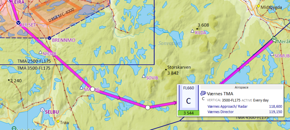
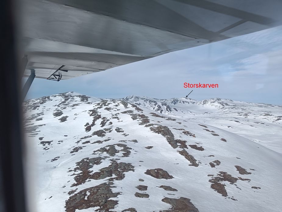
Pay attention to the lower border of the TMA (ENVA). It’s 3500 feet. Mountains in the area are higher than that. Storskarven is at 3842 feet. I have walked up that maintain, been on the top. There I am higher up than I usually fly in that area Back home again, I got a lift with the Army Cub and took some picture. This is what it looks like SW of Storskarven. This is at a flight altitude of perhaps 3200 feet I would guess. The bottom of the valley is about 1900 feet at that point. We flew over the mountain slope at perhaps 2-300 feet AGL, and with only 300 feet up to the TMA I sometimes wonder what I shall answer if I flew into the TMA without clearance, and they ask me to get out. Just “unable” or “this aircraft don’t handle granite well”
In Germany we have kind of a different situation compared to many other countries: The airspace structure today is much simpler in many parts of the country than it used to be 35 years ago (when I started flying).
Despite this – and the fact that now we have GPS which was largely unknown at that time – the airspace infringements have actually increased, not decreased (even when corrected for higher traffic). Reason imho is twofold:
1.) The consequences of an infringement at theses days would have been to be escorted to the next military airbase by a starfighter.
2.) Exactly due to the lack of GPS nobody would have tried to track the boundary of an airspace by just few 100m but we kept well away so that we are clearly out of the airspace (mainly due to 1.).
Or, to cut it short: We took airspace infringements much more seriously than we do today – and yes, that had the consequence that many areas where we can easily fly today have been de facto closed for VFR traffic (esp. for gliders which I flew these days).
Therefore the simple reason for most of the airspace infringements we see today is that we as pilots do not take airspaces seriously enough to really do everything we can to avoid (everything including not doing certain flights).
This not taking seriously enough is typically expressed in different forms: Some pilots even openly say “there is nothing serious and for sure nothing dangerous in scratching this airspace for som 100ft/100m” others are more talking about some kind of self defense or civil disobedience as the airspace structure is so complex and/or so restrictive that it is an undue burden to really comply. Some even argue that it should not be an airspace infringement at all if you actually infringe the airspace but only by a margin that could also be caused by some very unfortunate combination of instrument errors…
But in the end it is all the same: If we took airspaces as serious as granite, we would hardly do any infringement (by more careful planning, using technology like GPS more carefully or just keeping more of a safety margin).
The argument that it is so difficult because (in contrast to granite) you can not see the airspace boundaries is only ostensibly true: If that was the case, there should be much more CFIT accidents in IMC, where you can not see the border of the granite either. But in IMC we do exactly that: We keep such a big margin between us and where the granite is supposed to be that even in unfortunate cases of several errors adding up we still not hit it.
I don’t think you can equate IMC which to me indicates IFR (outside of UK) and VFR into CAS.
In IFR we have a plan part of which is to fly at 1000ft above highest obstacle in 8Km (2000ft in mountainous areas) and you just plant that way and ATC helps you fly it. IOW airspace is not an obstacle.
In VFR it is totally different. Yes you plot a route at or above MSA but that could mean flying in CAS for which you need permission.You cannot guarantee permission, so at the planning stage you need to look for an alternative route. But unless you are prepared to go and ask the airspace owner for transit and then do a 180° if refused, your alternate route could add an hour or even 2hrs to a simple 1hr journey. Especially so if the penalties for touching CAS or even 200m or 200ft from it can result in a draconian penalty from which no one learns anything.
Some regions have very complicated airspace structures which require VFR pilots to plan to squeeze through tight corridors between different airspaces and communicate with lots of different ATSs whilst at the same time avoiding entering IMC which is pretty difficult in the UK at the best of times🙂. Fortunately, the UKs attitude to flying on instruments is not as strict as in other countries. However, for those who have not been educated in flying in IMC, it could be a case of avoid the clouds, have a panic attack when you are in them, or infringe a bit of CAS.
If you are likely to lose your PPL if you take the latter choice and your life if you choose the second alternative, which do you choose?
IMO with current airspace design and the likelihood of more complicated CAS in the future, 3 things are required
1) More joined up ATS so that VFR can more easily get transits for most of their intended route. The easier it is to transit a zone and the earlier pilots can get permission to enter a CAS the less the number of CAS busts. (I think that should be obvious)
2) The ability of ATS to warn of possible CAS busts and advise on how it could be avoided, especially if a pilot is struggling to avoid deteriorating weather.
3) Using busts to educate all pilots, ATS, CAS planners and regulators, rather than a means of punishment.
Everyone makes mistakes but IMO the best way to reduce CAS infringements is to make access to CAS and transit through it more available at the planning stage of a flight.
@Malibuflyer – Airspace = Granite…seriously?? I have no idea what you fly or where, but you are part of the problem, not the solution with that attitude. If you seriously think that I have ever taken airspace busts lightly in the last 30 odd years I have been flying and that I take it less seriously now, then you are mistaken, however Aviate, Navigate, Communicate is the order of the day, then and now. Just get hold of any map from 30 years ago and compare it with a map today, and the added airspace and complexity is plain to see. I seriously doubt that there are very many pilots who dont care about infringing airspace.
I do know for sure that in the past many minor airspace infringements went unreported. In the last 5-10 years there has been a trend to record more of these minor busts across Europe, and in the UK it is now mandatory with auto-detection & reporting software. That this has happened with the privatisation of ATCS may or may not be coincidental…
Regards, SD..


