
Given the first GRAMET, how do you read it?
Given purely this GRAMET, I would interpret it to mean low cloud with tops varying up to about fl100 possibly with another layer above.
What would you expect?
I would expect something vaguely along this line. If cloud tops were anything from 5000-FL150 I wouldn’t be surprised but would be less happy to find cloud tops above FL150 (again, given just this one source).
How would you plan your flight in those given conditions?
Pretty much as I mentioned in my earlier post. I’d plan for FL100 (or more if you’re able) and stop climb when I’m likely to remain clear. I would only stop climb if I knew that the wind was more favourable or other reasons to stop the climb, otherwise higher tends to be better.
What would your thoughts regarding risk assessment and out-strategy be?
If I launched purely with this info, I would do so climbing up to the PLANNED level (100 or more). If I couldn’t get on top I would evaluate to see if I was encountering ice (I fly something that has decent deicing so flying in light icing is not a problem for a while). If I was only getting a bit of ice I would likely stay there and just use systems against it given the relatively short flight. If I was getting more than I was happy with I would descend knowing that the temperature was positive nicely above MSA (having checked it on the way up). I would then continue the flight in IMC to destination providing that MSA wasn’t a problem at the new level.
What other questions should be asked?
As others have said more than 1 point of information should be used. My own plan is what I personally would be happy with (aside from launching having only used a GRAMET for planning) and it reflects the aircraft I fly and also that I spend a silly amount of hours each year flying (both by hand and with A/P) in IMC for work so I am comfortable with it and have a relatively high threshold for tiredness caused due to increased concentration.
If the actual was like this
and if the vertical columns above the 0C line are scattered/few CU/TCU, then flight below the 0C line should be “safe”. Well, maybe not if it is OVC001/50m on the ILS 
However I cannot imagine conditions where you have such low cloud, almost all the way to ground, and have convective wx above that. The convection will suck up any low level crap, generally. This is evidenced by the metars.
The question of departing with purely this info is academic because, frankly, only a complete idiot will depart without getting actuals – in this day and age when everybody has a smartphone capable of getting weather.
Yes I do know of pilots who used to depart without getting actuals before going, and some of them are still alive…
There might be scenarios where mobile data is not working when you need it (very possible, IME) but that is just an argument for having two ways of getting the data (say the phone, plus a tablet with a 3G radio in it and, yeah, another SIM card in the tablet). If you cannot even get tafs and metars for airports along the route then you are just being very foolish and will one day end up in a very difficult situation.
The resolution of the GFS numerical forecast system is 0.5 degrees, which is about 30 NM. Each grid point spans about 30NMx30NM. For a reliable low level weather prediction, the resolution needs to be much higher.
The local European models have a resolution of up to 2km. The pan-European models about 7km. We’re trying to get access to European forecast data but it’s difficult as the data is not openly available.
Years ago I used to have a premium rate phone number for a commercial weather forecaster, and occasionally phoned him up for a second opinion. Avbrief used to offer that service but later that shut and I used to phone up somebody else – about £1.50/minute. The last one told me he was paying £5000/year or so, for access to the UKMO 3D model. But he was limited on what it could be used for and I think for example republishing it as a public “GRAMET” would blow the whole UKMO monopoly wide open and they would want millions for it.
This was the weather this morning at Aschaffenburg (EDFC):

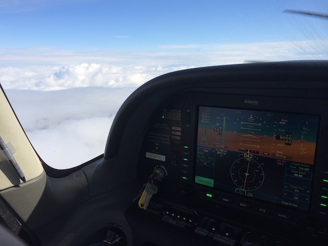
In cruise at FL90 I had:
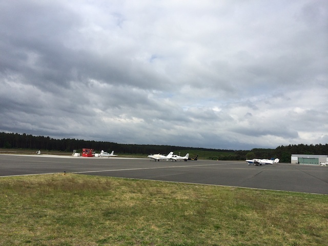
Upon landing I needed to seize the opportunity and cancel quickly at 3600. From the ground at EDAZ it looked like this:
METARs from EDDB:
EDDB 120650Z 24014G24KT 9999 FEW025 BKN050 12/08 Q1005 NOSIG=
EDDB 120720Z 24017KT 9999 SCT025 SCT050 12/08 Q1005 NOSIG=
EDDB 120820Z 25017KT 9999 BKN025 BKN035 13/07 Q1006 NOSIG=
The TAF from 1100Z is now:
EDDB 121100Z 1212/1312 23015G25KT 9999 SCT020 BKN030
TEMPO 1212/1216 TSRA SCT015CB
BECMG 1216/1218 24008KT=
The earlier TAF was a bit more optimistic but I can’t find it anymore.
The second GRAMET posted above was about right except for the low level stuff within the boundary layer.
Hi
I was hoping someone could help me interpret a GRAMET created on the brilliant GRAMET part of Euroga. Its for a flight tomorrow at 12:00z from Corfu to Brindisi.
I am struggling, specifically, with assessing the risk of CB cloud / Thunderstorms. On the one hand the GRAMET shows no cloud at my altitude (FL100) but does indicate a risk of TS, in fact the lifted index near Brindisi is a very low -7,5 suggesting violent TS near my destination.
How would you interpret this?
Many thanks
Jorgen
[ image fixed up – see this ]
It looks like a go to me. If you can fly earlier, do that. Otherwise just have a look at the satellite/infrared/strikemap before you takeoff. And don’t go IMC.
The TAF has not much else but CAVOK for the next 24 hours:
TAF LIBR 291100Z 2912/3012 09015KT 9999 SCT020 BECMG 2918/2920 16010KT CAVOK BECMG 3004/3007 16015KT 9999 SCT020=
This is how it looks on the DWD MSLP chart. There will be a cold front moving into your direction.
Like Achim said: Just check the actual weather before you depart. In case you’re experiencing bad weather, the escape is to turn back…
Thanks all, yes I also had the other data, my question was just how to interpret a GRAMET with no cloud but a low lifted index. I’ve made several flight in the last few weeks where the Ogimet GRAMET showed no cloud but actual weather was mid level overcast (ca FL100) with embedded CBs. Then discover this website’s version that seems to use a lower threshold for showing cloud cover.
I’m just trying to learn how to best interpret the chart and welcome your experiences with actual conditions vs what the chart indicates. Think it’s a brilliant planning tool for IFR flight.
Jorgen


