What a day it was! Crossed Germany all the way from Hohenems (Lake Constance) to Lübeck (Baltic Sea) today. Unforgettable.
I found an article that said a GAFOR was a general aviation forecast, but what does the ‘c’ stand for? I couldn’t see a decode for it. I assume it’s not ‘cold’ and it’s CAVOK? If so, that’s amazing for a whole country. I bet if you take a typical TAF or METAR for the UK, and divided the whole of it into 20 parts, you wouldn’t find more than five CAVOK’s.
I assume it’s not ‘cold’ and it’s CAVOK?
It’s a german additon to the usual GAFOR classes. It stands for visibility > 10km and ceiling above 5000ft. But it is not equal to CAVOK, because with CAVOK there can be no meteorological phenomena like precipitation.
C-LEAR 
I had always understood GAFOR to be a Germany-only thing. What others countries publish them? Who actually owns the definition?
And, do I understand that, to consult them in Germany, one needs to subscribe to the service, and pay for it?
I had always understood GAFOR to be a Germany-only thing.
I know that Austria, Switzerland and France (they call it GAFFO I think) have GAFOR as well. Probably others as well that I have not come across yet.
And, do I understand that, to consult them in Germany, one needs to subscribe to the service, and pay for it?
I think so.
France has something very similar (although they don’t call it GAFOR). Italy, too (they do call it GAFOR).
Austria and Switzerland have GAFOR, too, but they don’t go by areas. They define routes instead, which makes a lot of sense in the Alps.
Here’s the Swiss GAFOR map for yesterday:
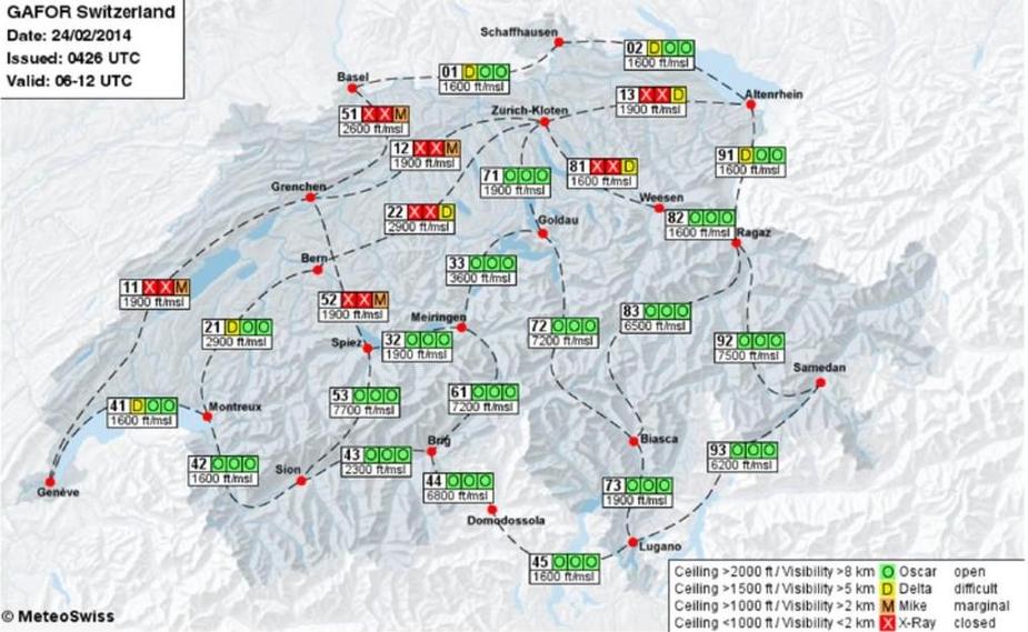
As you can see, they don’t use the “Charlie” code at all. They stop after Oscar.
BTW, I have flown VFR from the Domodossola area to the Altenrhein area yesterday and it was awesone.
The german GAFOR is less useful. But it is very “official”. Hence, a lot of emphasis is put on it in PPL training. Also, you will always find some (ususally nonsensical) reference to the GAFOR weather in german accident analysis reports. 
But: it is still useful on a day like yesterday. You glance at the GAFOR map for one second and your weather briefing is basically done (maybe add a glance at the wind forecasts). Likewise, when the map is all red, you know it just can’t be done VFR.
Yes, the map is only available to DWD (“pc_met”) subscribers.
It’s a german additon to the usual GAFOR classes. It stands for visibility > 10km and ceiling above 5000ft. But it is not equal to CAVOK, because with CAVOK there can be no meteorological phenomena like precipitation.
And yet, I bet yesterday it could have stood for CAVOK and the chart would still have been the same…
I was on one of my six airline flights this week (wish I could fly these myself but company policy won’t permit. Different discussion). I usually sleep through all domestic flights, but yesterday, I couldn’t take my eyes off the window for even a minute. We flew from Düsseldorf to Munich and had great visibility all along. Magnificent views in the climb-out of Cologne with the cathedral, Lanxess arena, EDDK, Bergisches Land later on, then the Middle Rhine Valley, then Odenwald/Heidelberg before we turned southeastbound via Schwäbisch Hall to Munich, with ever-so-stunning views of the Alps. This is all assuming I identified these places correctly. Enroute, I also saw lots of smaller airfields and lower and slower traffic.