Peter wrote:
due to terrain shaping the airflow.
But that’s not it. It’s part of it, and makes it more unpredictable depending on the stability and winds I guess, but the cause is inversions (as can be read from the accident report). In Ukraine, which is mainly flat, I would think the layer is more stable.
Peter wrote:
An inversion is a horizontal layer, while wind flows horizontally, so how could a horizontal layer block the wind?
It’s not blocking the wind, there’s just no reason for the wind in two different layers of air to be going the same direction. If the layer of air below the clouds is going in one direction, it doesn’t force a different layer of air above the clouds to go in that direction, and there’s just not a lot of friction between the two layers to allow one layer to force the other to go in a specific directiion. It’s just two very well lubricated layers moving in different directions, just as two well lubricated pieces of metal can easily slide over each other.
Peter wrote:
An inversion is a horizontal layer, while wind flows horizontally, so how could a horizontal layer block the wind?
Wind in different layers would be independent if there wasn’t for vertical movement of air between different levels. The inversion blocks the vertical movement.
Vertical movement is btw the reason for why gusts veer (the wind direction moves clockwise). A gust is caused by air from a higher level descending to the ground, bringing its momentum with it. As wind generally veer with altitude (and increase in strength) a gust will do the same.
For the same reasons you won’t have wind gusts with a stable layer near the surface.
Sure; gusts are higher level wind briefly dropping down. But that’s a different topic.
there’s just no reason for the wind in two different layers of air to be going the same direction
OK, but what is wind? Whatever drives lateral airflow at one level should be driving lateral airflow at a different level. It is a pressure gradient which drives it. Why would the horizontal pressure gradient be so dramatically different?
Peter wrote:
Sure; gusts are higher level wind briefly dropping down. But that’s a different topic.
The physics behind gusts is the same as the physics behind an inversion separating layers with different wind.
I am trying to learn, not generate bandwidth and “I know the answer but I am not going to tell you” posts.
But never mind.
I just find it sad, as the person who started this forum more than 10 years ago.
One liners are completely useless, most of the time.
Peter wrote:
I am trying to learn, not generate bandwidth and “I know the answer but I am not going to tell you” posts.
And I’ve been trying to explain with two posts that certainly wasn’t one-liners. But being told that explanations are off-topic is not encouraging.
Peter wrote:
Why would the horizontal pressure gradient be so dramatically different?
It doesn’t need to be. It could be the opposite also.
There are two forces driving the flow: momentum and pressure. This is expressed as:
Sum(F) = m*a or, as in fluid dynamic terms:
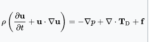
For simplicity we can disregard convective terms and body forces and what’s left is:
rho * partial(u)/partial(t) = – delta p. partial(u)/partial(t) is acceleration. rho is mass per volume and delta p is the (pressure) forces. So it represent Sum(F) = m*a per unit of volume.
What this is expressing is that the pressure drives the acceleration. The opposite is also true; acceleration, or in most circumstances retardation, creates a pressure. The wind could be purely due to momentum of the masses of air, the driving forces (pressure) have all disappeared. A pressure gradient at this very moment in time is not a requirement for the wind to blow (at this very moment in time). There could be several of these layers. Then they mix, get obstructed by mountains, and makes everything pretty much unpredictable, and people crash.
Peter wrote:
Whatever drives lateral airflow at one level should be driving lateral airflow at a different level
This may be the case, but we have two airmasses with different properties – the lower one is turbulent with stuff moving vertically (which as glider pilots we attempt to take advantage of), but the other is smooth. The vertical stuff, which in the case of a good soaring day, is being driven not by the pressure system on the synoptic chart but by the sun heating the ground. This in turn must affect how this airmass is moving horizontally, meaning you’re going to get the turbulent airmass going at one speed and the smooth airmass above which isn’t subjected to this stuff (let alone affected by orographic effects) going at a different speed, AIUI.
One thing you’ll notice where the lower air is very convective and producing TCUs is you’ll see lenticular clouds on the lee side of the TCU, just like mountain wave, caused by the vertical movement (and of course a large parcel of upward moving air has quite a bit of momentum, so won’t immediately start moving horizontally at the speed of the airmass it’s pushing up into) pushing up into the smoother stable airmass above pretty much like mountains will do to a stable airmass.
alioth wrote:
It’s just two very well lubricated layers moving in different directions, just as two well lubricated pieces of metal can easily slide over each other.
Yes. We have this situation here in the L.A. basin area pretty much every day of the year. Mostly benign, but can become quite intense. We have an inversion layer almost year round and the wind shear can be impressive.