Peter wrote:
IMHO the SigWx charts have limited value to piston GA. They are a bit like the UK Met Office F215 – contains everything on one page
Most SigWX charts are useless to GA. TEMSI/EUROC and some LLSWC are on the other hand very useful if you know how to read and interpret them. They are man made vs “mindless” model outputs. that alone makes them quite valuable.
Peter wrote:
Sure, but they do have this – from ADS-B OUT data showing TAS and GPS GS Winds aloft at jet altitudes are accurately known these days.
they have been for quite a while, even with “simple” models as GFS. Not sure what you mean with TAS and winds aloft displays airliners have, most GA planes with even simple EFIS as an Aspen have those too these days.
I wouldn’t agree that airliners being more capable means they need less information. The charts that BA use for its flights are the WAFC SigWx which still highlights a risk of areas to potentially avoid for us. Navigation around areas of intense CB activity or high level turbulence.
http://www.lennuilm.ee/prognoosiinfo/kaardid/wafc-euroopa-kaardid/sigwx-euroopa-18-utc/?lang=en
Then if you want more details and what flight levels to use, then EUROC are great. In flight I use the Golze, and the Aspen gives me instant wind & temp data which feeds to the GTN650xi giving relatively decent ETAs.
I do also look at the F215 and Windy but it’s hard work making a judgement on that. ECMWF is more accurate than GFS, especially in Summer and Winter when the weather forecasting is more challenging what with the AO/NAO being all over the place.
I found this but it’s mostly in French.
https://www.lavionnaire.fr/CodesTemsi.php#FrontSatel
Is there others that translate the Key?
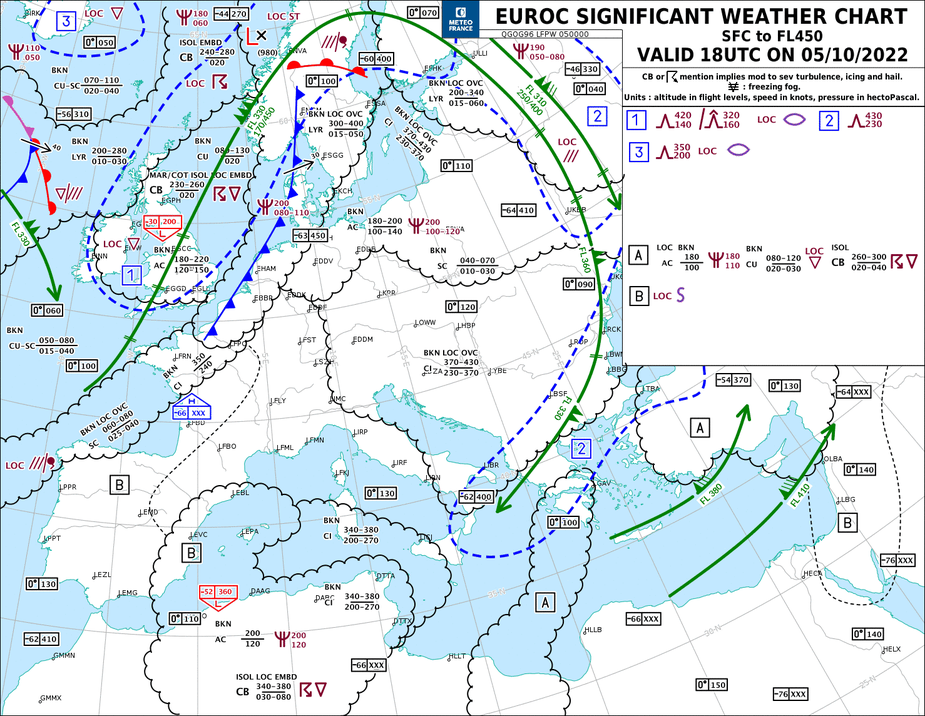
On the TEMSI, North of sector B you have BKN LOC OVC 060-080 and 025-040
Is this an indication of two layers with bases 025-060 and tops 040-080 or bases varying from 025-040 and tops varying between 060-080 of SC?
I presume its only Layers when it states “LYR”? – example being the cold front stretching from LFRN to ENGM? -015-050 & 300-400
pilotrobbie wrote:
On the TEMSI, North of sector B you have BKN LOC OVC 060-080 and 025-040Is this an indication of two layers with bases 025-060 and tops 040-080 or bases varying from 025-040 and tops varying between 060-080 of SC?
The latter. Base is between 025 and 040 and the tops between 060 and 080.
pilotrobbie wrote:I presume its only Layers when it states “LYR”? – example being the cold front stretching from LFRN to ENGM? -015-050 & 300-400
That cold front has ceilings between 015 to 050 and tops between 300 and 400. The LYR statement indicates that clouds are in layers, but it does not give any information about the altitude of those layers.
pilotrobbie wrote:
pointed me to the EUROC charts available on the Aeroweb site
Thanks for sharing, haven’t come across these yet. Seems valuable.
Unfortunately, the EUROC is now as useful for GA as the SigWxr Charts.
From 2022 decembre 29th The Meteo-France EUROC SIGWX evolves. More simple, closer to the ICAO High altitude SIGWX standard. It still provides significant and relevant information for short and medium Haul on Europe area
So now there’s no-more low-level weather.
See brief; https://aviation.meteo.fr/affiche_actu.php?file=Communication-_Evolution_du_TEMSI_EUROC.pdf
Today’s Chart for example;

Only icing below FL100 retains special treatment:
- If the risk of icing is associated with cloud layers whose base is below FL100, the base of the icing
associated is indicated with “base <100” (for example disturbances in LYR layers or AC layers alone).
- If the risk of icing is associated with cloud layers with cloudiness greater than BKN, and whose top
is below FL100, a specific scalloped area is drawn and the icing symbol is indicated with a
“vertex <100”.
- The characterization of the risk of icing is unchanged; it may be severe or moderate.
Bit annoyed at this change. So other than the UKMO F215 we are left with no low-level weather except METARs/TAFs and learn a Skew-T?
As the TESMI/EUROC doesn’t really cover the SFC anymore (now limited to FL100+ to interline it with ICAO), this website I’ve found does a similar job. Apply via here [Home | Austro Control – Aviation Weather)]
Then Email: [email protected] with your license to support your application.
Includes Low-Level SWC on the German Charts which covers UK and most of Europe. Special charts for Alps included too and the IFR SIGWX also on there.
For Spain, Med and further afield – FL100+ this (EUROC/TEMSI) is still relatively useful – [AEROWEB (meteo.fr)