Can anyone really make any sense of that? Personally I think it's impossible to even get an understanding of what the general structre is in this area. (The same is true of plenty of other areas in the UK).
The answer is No. But SD can be configured either in planning, or navigation mode, to show or hide things below a certain height. In navigation mode I generally dont show anything above 10,000 ft as I rarely go that high (planned, or unplanned). That removes a lot of it. In flight mode, I hide stuff 4,000 above me, as I am generally unlikely to make an uplanned deviation that requires me to go up 4,000 ft.
Colm,
first of all, excuse me if I wasn't clear. Of course, when talking about airways in the UK, I was talking about those longish "blocks" of controlled airspace, which are indeed very important to the VFR pilot. And of course, the mere airway "line", as depicted on IFR charts, does not mean much to the VFR pilot.
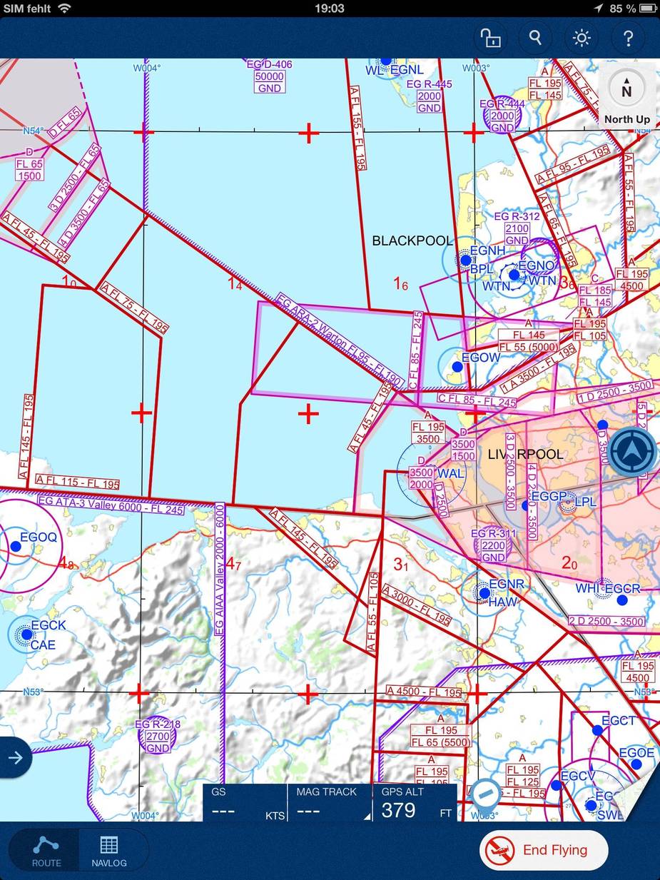
Having said this, thanks for posting a good example (the airspace west of Liverpool). Whether the SD depiction or the PFMS depiction is "better" is certainly open to discussion. Let me just agree with Achim and say that I am not 100% sure if merging the airspaces to the extent PFMS seems to do is the right choice.
What is a fact is that Skydemon does at least depict the airway aispaces. This - and that was my point - is not the case with ANP.
Whether it is particularly user-friendly is another matter.
Let me add the depiction from Jepp MFDVFR:
And, as a very bad example, ANP:
So, four programs and four very different depictions of the same piece of airspace. Oh dear...
So, four programs and four very different depictions of the same piece of airspace. Oh dear...
This is a problem when you don't know your settings on your chosen product (as Peter said also), or you rely too much on technology and don't do enough sanity checking on paper.
But you're not saying any of them are wrong are you? Just that their representations (default settings or not), are all significantly different?
But you're not saying any of them are wrong are you? Just that their representations (default settings or not), are all significantly different?
Not quite.
From the screen shots above, Jepp seem to do it in the same way as PocketFMS/EasyVFR & NATS paper charts. Ie they merge the airways when they form the same airspace. Or as Peter more elequently put it, they don't create boundaries on the chart where none exist in 3D airspace.
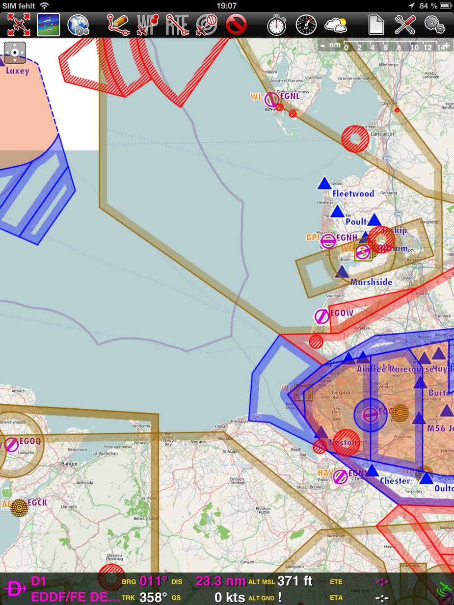
SkyDemon while technically correct, results in an unreadable mess unless agressive filtering is applied. But at least you'll get the appropriate warnings if you are about to enter the airspace.
Air Nav Pro seems to totally miss the airways altogether so you don't see them for planning and don't get any warnings. They are simply missing from their database. There is no other way to read that image other than the airspace is missing. I don't know enough about the product to know if it's possible to turn off certain types of airspace but trust boscomantico know what he was doing when posting the screenshot.
The only saving grace for ANP would be that if you bought a CAA chart as a background, then it would be shown on that chart, but still you'd get no warnings if entering the airspace.
Colm
I use SD on my ipad mini mounted on my yoke….I have been using it since last year and find it fantastic….however today I managed to close the profile view at the bottom of the screen and have no idea how to reinstate it!! Can somebody please help?!
AnthonyQ
Plan a route and it should appear – otherwise I am sure that the SkyDemon help forum has the answer – http://www.skydemon.aero/help/
Thanks Peter….you are correct…doh!
G1000 and Skydemon
Since last year SkyDemon can export FPLs in Garmin-specific .GPX format. The G1000 manual says it should be possible to import them from an external SD card and use them in flight. I tried several times to import the files without success although I followed the procedure. The ‘Import’ option stays greyed out. The internets were helpful in offering a lot of snake-oil like solutions:
- small SD cards (I tried 32Mb)
- restart G1000 with the SD card in slot
- etc etc
Am I doing something wrong?
Any lucky G1000 wizards around? Thanks a lot!
What is garmin specific GPX?
I know about GPX, which is used for example for google earth, and Garmin FPL, which the G1000 can read.
You can recognize the file format by looking at the first XML tag (in a text editor), if it is gpx then it’s a GPX file, if it’s flight-plan, then it’s a Garmin FPL file.
If it’s the second, then try to rename the file extension to fpl.
If you need example fpl and gpx files, you can download them from Autorouter
Oops. I messed it up. It is indeed a .FPL XML file.
<?xml version="1.0" encoding="utf-8"?>
<flight-plan xmlns="http://www8.garmin.com/xmlschemas/FlightPlan/v1">
  <created>2014-04-25T12:03:48Z</created>
  <waypoint-table>
    <waypoint>
      <identifier>EHLE</identifier>
      <type>AIRPORT</type>
      <country-code>EH</country-code>
      <lat>52.460000</lat>
      <lon>5.526667</lon>
      <comment />
    </waypoint>
....
  </waypoint-table>
  <route>
    <route-name>EHLE EDRK</route-name>
  </route>
</flight-plan>