Would GP accept a more complicated airway route e.g.
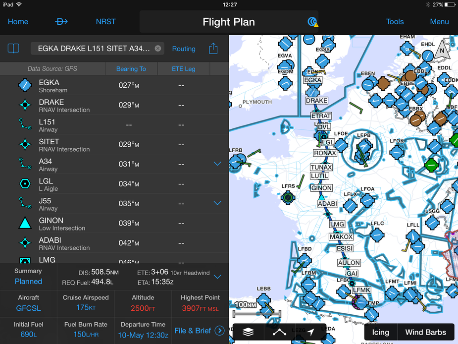
EGKA DRAKE L151 SITET A34 LGL J55 GINON DCT ADABI DCT LMG G36 GAI DCT CS ORBIL11 LFMK
Yes, you just have to remove DCTs as it doesn’t recognise them as waypoints! (Transferred as cut-and-paste which, as David observes, isn’t any real hardship)
Thanks for your comprehensive response Dave. Makes sense.
@David : Thanks for the excellent review.
The Carcassonne trip was the first longer trip with GP for me, having switched from SD a few weeks ago. I am very satisfied with my choice. I only miss (or have not yet found) the following features:
- procedures from the approach plates (SID, STAR, IAP) cannot be loaded in the flight plan
- there is no graphical logging of the flown route
- the base map/airspace map doesn’t include info frequencies (only an issue when you have not bought the respective national VFR map)
blueline wrote:
- procedures from the approach plates (SID, STAR, IAP) cannot be loaded in the flight plan
You can add a departure or an arrival – click on the departure/destination airport in the plan and click either “Add Departure” or “Add Arrival” as appropriate. You cannot add an approach.
blueline wrote:
- there is no graphical logging of the flown route
Correct.
blueline wrote:
the base map/airspace map doesn’t include info frequencies (only an issue when you have not bought the respective national VFR map)
Also correct. And this one is a pain IMO for VFR flight, just like it not giving frequencies for airspace. You could rely on the frequency you’re already on to give you a suitable enroute frequency to change to, but to be self sufficient you’d have to get the frequencies from somewhere else. As you say, it’s ok if you’ve bought the rasterized VFR national chart and it has the frequencies on there.
I use both, SD mostly for VFR flying, GP for IFR, SD has nice feature of pasting VFR arrival/departure chart on map , it`s especially helpful when transitioning complicated MCTR/MATZ airspaces in my country (Poland) with lot of VRP`s not depicted on normal chart or map. I am just courious , is there any possibility to run two apps at the same time? Mabye on Ipad Pro?
You cannot add an approach.
Makes you wonder what’s the reasoning behind that …
Garmin seem to be using the free AIP plates for the approach plates. For some reason they have (in effect) chosen to not georeference these. They have however clearly managed to obtain digital versions of the sids and stars. My take on this is that they were able to do a reasonably priced deal with Jeppesen which included the sids and stars (after all, even my KLN94 has these in it’s database) but a deal on the Jepp approach plates (which are the only approach plates in existence, for Europe, in a digital form) would have been too expensive.
They do georeference the approach plates Peter. And the navdata is from Jepp so must include the approaches.
The database is from Jepp but the terminal charts they display are the free AIP ones. They have georeferenced those (and presumably – I wasn’t looking when David was playing with it – they will display the aircraft lateral position on the AIP plate) but for some reason one cannot load the approach into the flight plan.
Can GP display Jepp terminal charts instead of the AIP ones?
I am not sure that all Jepp data includes approaches.