Garmin Pilot review
After our trip to Carcassonne, I’ve done a write-up of the Garmin Pilot app. Feedback is welcome.
David, as a long term user I think your review is pretty accurate.
Only thing I would say is that apparently VFR flight plans can now be filed using the app although I haven’t tried it.
I have the CAA VFR chart which is useful for VFR to IFR departures from say Turweston while awaiting a join but never bothered with the paid for IFR enroute charts. The navdata itself seems sufficient. The airfield data is still being populated but is getting better. Still miles from how it is in the US though and it really needs work. I made those points to Garmin in Germany at the Expo and they said a significant effort is now being made to enhance that side of it.
I’m a convert to Garmin Pilot and have binned SD. My only minor gripe is that airspace boundaries are sometime a bit dominant!
Dave, have you binned SD for any particular deficiencies, or is it perhaps because you have FS210?
I just don’t feel I need it. My flying is quite varied from VFR helicopters within the UK to European and Middle East IFR. The flight planning interface on Garmin Pilot is a delight and especially useful if you have the luxury of a Flightstream interface with a GTN750. Furthermore, split screen options are fabulous and easily adjusted with overlay management being very simple. Overall, it just feels like a more professional product which, once you’ve weaned yourself off SD, is far more intuitive; think of it like moving from Microsoft to Mac and suddenly realising how quirky Windows can be. I echo the observations about the lack of frequency labelling but I find that once outside of UK this isn’t really an issue as the general protocol for FIS (finding someone to talk to outside of CAS) is far simpler.
My other packages are RunwayHD (excellent for slow/low helicopter work with chart merging from 500k through 250k to OS) and Jeppesen FD linked to RocketRoute for the pure IFR work. If autorouter ever provided a simple export capability for FPLs to Jepp or Garmin Pilot I would get rid of RR instantaneously. Furthermore, if Garmin Pilot plugged some coverage holes (Greece, Middle East) I would probably bin the Jepp.
A current screen grab from Lisbon (green and yellow is weather radar). I just can’t get as much information on a SD screen grab.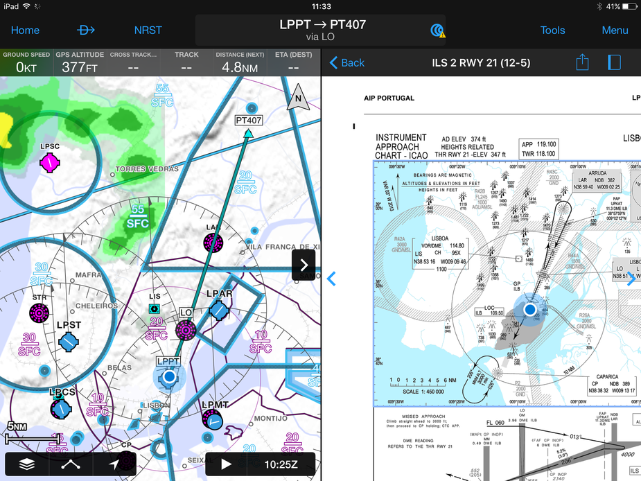
Achim (who did the Autorouter but doesn’t post anymore  ) says the RR to JeppFD route transfer is probably done via app to app communication. He will try to see if he can generate a format usable by Garmin Pilot. That would then open up a transfer route to a GTN box (via FS210 and bluetooth).
This is also applicable (Avidyne) though I obviously don’t think GP will ever send a flight plan to an IFD box 
Dave_Phillips wrote:
If autorouter ever provided a simple export capability for FPLs to Jepp or Garmin Pilot I would get rid of RR instantaneously.
I thought it did but I’ve never been able to get them to work.
I dropped RR two years ago and now use SD for “situational awareness” and NOTAMs mostly, Jepp FD, and I’m now trialling GP as well. I must say I like the appearance of GP but SD’s profile view is better. I also like SD’s logging feature – is logging in GP? Can’t find it.
In Peter’s thread about Avidyne, he quoted this route from autorouter:
EGKA DRAKE SITET ETRAT DVL LISEU LGL RONAX TUNAX LUTIL GINON ADABI LMG MAKOX ESISI LAVRA AULON GAI CS LFMK
There are lots of ways to get that from your computer to your mobile device. I highlight it on the screen in the browser and click a toolbar button which uses Pushover to send it to all my mobile devices. I then do a cut and paste of that in to Garmin Pilot. So it’s a few button pushes but you can do the whole thing in about 15 seconds. Obviously getting it from the iPad to the panel requires the necessary (over priced) hardware.
chrisparker wrote:
I also like SD’s logging feature – is logging in GP? Can’t find it.
Logging as in an electronic logbook? It’s on the main menu under “Logbook”. It is completely automated, has tons of info (all the usual plus stuff like max speed, max altitude) and syncs between multiple devices.
If you mean track logging I haven’t found it, if it exists. Funny how you prefer SD’s profile view; I’m the opposite. I would say that SD’s portrayal of weather in profile is better but the terrain depiction and associated grey-out of the plan view is better in GP. I think they’re both great products and inevitably people will end up preferring one over the other.
PS. You mention SD notams – this is one area where SD has it nailed.