My WX500 displays concurrently in 3 places
and each of them has a separately adjustable radius and the angle mode (forward only or all around). The WX500 sends all strikes, regardless of range, to all display devices.
On the MFD (KMD550) one can display just the strike screen, or have the strikes overlaid on the map. There are various caveats e.g. if your heading source (fluxgate+DG / SG102 etc) has failed then the strikes will be visible only on the strike screen, north-up.
I still have to say I have found stormscope poor vs download strike data.
Sure the Blitzo data will be better than a stormscope. Even a single strike shows up on the Blitzo site (I can confirm it from observations) and while that is also true for a stormscope, the Blitzo position will be spot on.
But you can’t get the Blitzo data when airborne without a working data connection.
Right, thanks all for the quick reply. I’ll investigate this.
Does anyone use the WX500 with an Aspen?
I am very happy with my WX1000E with NAV function it gives me alsmost EHSI capability.
My SS has helped quite a bit to avoid the worst. Its just that additional tool you need to make the right decision weather wise. The problem with this convective stuff is builds in minutes and then a SS gives you the real time situation.
L3
In addition I thing the linked article from NCYankee is very well written and informative. Though I think a good install of the unit is crucial…
JasonC wrote:
I still have to say I have found stormscope poor vs download strike data.
In what way did you find SS inferior to download strike data?
1.SS shows a lightning strike right away No delay.
2. It shows multiple strikes in clusters indicating the strength and direction of the storm.
3. Using the clear function lets you know
a. If building or decipitating
b. If its moving and which direction
4. You can differentiate between turbulence and lightning something strike data cant do.
The only downside at least for my unit the WX10A is the range. You can guestimate distance by decreasing range. Also when able, then eyeball the situation. Having ATC give guidance and listening to what others are doing on the Freq. that are in your area flying in the same direction also helps augment the SS. Of course the more info you have the better like my old XM Weather which gave good distance info. in addition to the above stated.
According to the last US AOPA mag, an NTSB report says that NEXRAD data can be delayed up to 20 minutes. This appears to have been implicated in some fatal crashes.
I wonder what the worst case is for the European wx radar service, as e.g. coming via the ADL120.
It could be that far fewer people fly “hard IFR” (e.g. in solid IMC, where TS is known or forecast, in unprotected aircraft) in Europe, compared to the USA. Of the people I know of, very few do it and most of those have had NDEs 
It is very easy. The ADL radar images get updated every 15 minutes. They come out 4 minutes after each quarter of the hour. So, you can have 4 minute old (very fresh) data in your cockpit. But at the very end of the 15 minute cycle, the data is 19 minutes old. But if you are aware of that, it is very useful. Of course, this applies particularly to strategic decisions (i.e. whilst still im VMC) and a bit less for for tactical flying (i.e. whilst already in IMC).
Yesterday, I flew from Bautzen (EDAB) to Lübeck (EDHL) nd there was weather right on my track. The ADL allowed me to make a founded decision ro deviate to the east (i.e. to pass in front of the weather, not behind it). Worked great and the weather was exactly as depicted on the downloaded radar image (the weather wasn’t moving too quickly). Also gave me the additional treat of a panoramic flight over Berlin (Schönefeld, Tempelhof, Tegel). Once again, great assistance by the DFS controllers. I had the opposite experience with an a$$hole controller from Prague Radar the day before…
@boscomantico
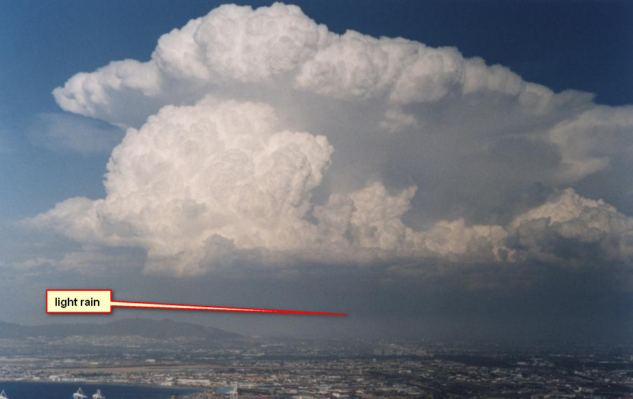
What I did on my last flights when it was about departung into IMC: I downloaded the last radar image a minute before I took off and I put the departure time to ten minutes after the hour, so the image was five or six minutes old. Of course I was overcautious again, because there was nothing in the area but light rain …
Of course I was overcautious again, because there was nothing in the area but light rain …
Depends on what the rain is falling out of. Obviously it will be falling from IMC, so… you might have: