EGKK 020850Z 27010KT 9999 BKN008 BKN015 11/10 Q0956
EGKA 020820Z 25013KT 8000 -SHRA FEW010 SCT029 12/11 Q0956
EGHI 020850Z 28011KT 260V320 8000 -SHRA BKN007 10/09 Q0960 RESHRA
May be the lowest QNH that EGKA has seen in many years.
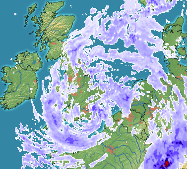
Intense LOW

Winds at Lydd now down to 31 knots. L2K reporting 29G50. Calais 36G55.
Low QNH values are very unusual in Croatia. Last week I recorded 985 at my base which happens once in few years.
Just been told that 953 was seen during the big 1987 storm, so this is pretty close.
Impressive wx….better to be seen from the gnd…
Strongest wind I’ve ever seen in a METAR:
METAR EGJJ 020550Z AUTO 25062G87KT 0650 +RA FEW005/// SCT009/// BKN011/// 10/09 Q0964 REDZ=
though I love the colours as provided by Windy, I’m not sure I’d be willing to tackle that breeze 

Graham wrote:
METAR EGJJ 020550Z AUTO 25062G87KT 0650 +RA FEW005/// SCT009/// BKN011/// 10/09 Q0964 REDZ=
Interesting and typical AUTOMETAR stuff. No observer would find DZ in conditions like this… Also, in a situation like this, no automat can give a reasonable observation (see the slashes, I also doubt the vis and just about everything else). The wind is consistent with this kind of weather and that is the only thing I believe in Autometars, along with temp/dewpoint and QNH. Clouds, vis, present weather, past weather, are notoriously unreliable.
Mooney_Driver wrote:
see the slashes
AFAIK these slashes mean that the cloud type can’t be determined. Is there reason to doubt the cloud base figures?
Airborne_Again wrote:
Is there reason to doubt the cloud base figures?
In METARs cloud type is only given if it’s TCU or CB.
Autometars generate their cloud figures from ceilometers. The quality of the determination depends on how many there are and on the algorithms used to convert the data. As an observer, you have the possibility to actually take a visual round shot of the area and therefore see in much more detail what is going on. Personally, I find the data generated by automatic determination to be not very reliable and usually pessimistic. In conditions like that, all you can say with certainty is that there are low clouds.