EUMETSAT has a monopoly for IR images for Europe, AFAIK.
Their 15 minute images have escaped into the wild via advert-funded sites like SAT24, but there isn’t a corresponding good database of temperatures aloft. Such data could be obtained really well from airliners but currently the best you get is the GFS model (which is actually not bad for temp aloft).
I do have access to one private site which does such an overlay
but – we have discussed this before – the data is often wildly out and IMHO this is because they are just applying the ISA temp profile and colour coding it accordingly, which is obviously hopeless since the air is rarely anywhere near ISA.
This IR method retains the weakness that it can show the tops of very high cloud which is not relevant to GA – say a layer FL300-FL350. There isn’t any way around that other than to make a judgement on the overall wx picture, and often a total lack of radar returns indicates there isn’t anything there. You can also throw in a GFS forecast (e.g. the GRAMET) and if that shows nothing at all except confirming a high level layer, that is not bad.
Peter wrote:
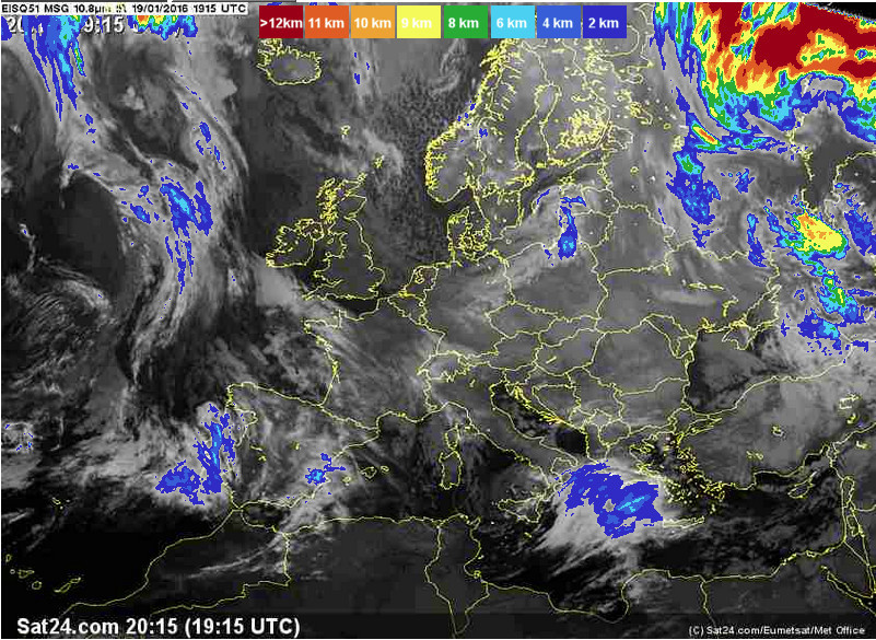
This IR method retains the weakness that it can show the tops of very high cloud which is not relevant to GA – say a layer FL300-FL350.
It will show the cloud top temperature of the highest clouds yes. In normal frontal clouds however, most of the time that is much lower. Look at the sample you have given, all the blue stuff is around 6- 12000 ft. That is not accurate enough though. What you need is a pic which gives temperature or at least a very much higher resolution in height.
of course you can read quite a bit out of the sounding already.
Yes; you can get other stuff e.g. in reasonably stable air masses you can get the 0000Z baloon sounding which can be highly indicative of what you will find the next morning at 0800Z…
However, for me, the overriding factor is often simply that the TB20 will go to FL200 enroute (not saying it can climb there with ice already on it!) so if you see tops around FL150 then an inaccuracy of several thousand feet is not a problem. This has worked for me for over 10 years and I have never yet had to turn back because I got it wrong.
However I have on a few occassions continued a flight in IMC, on the basis that the temps were too low for icing, and this works if you can verify there is no convective activity there (no sferics, etc). However I then got a couple of these.
If I understand the fuel servo icing theory correctly it relates to moisture in the fuel accumulating into droplets that freeze and restrict the fuel flow through the fuel servo, and thereby a drop in engine thrust.
Although I buy in to this theory, I do not see the difference between IMC/VMC in that respect. I would think that only OAT matters unless you think that you have a net contribution of moisture in your fuel during flight, high enough to be an issue.
What I would be more concerned about with respect to flying in IMC even in conditions where no visible ice accretion on the airframe, would be the accumulation of ice crystals in the air filter thereby starving the engine, particularly on turbocharged engines like the one AeroPlus was flying at the time of his incident. On injected engines this is countered by opening the alternate air, provided you are able to actually excercise the alternate air door, i.e. it is not frozen shut as it likely was in the aforementioned incident. Hence the recommendation stated in a number of AFM to open alternate air when flying in rain or icing conditions.
I am personally not concerned about flight in IMC if unavoidable, as long as there is no icing, and there is no risk of convective clouds on my route.
If I understand the fuel servo icing theory correctly it relates to moisture in the fuel accumulating into droplets that freeze and restrict the fuel flow through the fuel servo, and thereby a drop in engine thrust.
I don’t think so. Clean avgas freezes at -50C or so. The servo icing incidents I had were caused by water droplets at say -15C entering the air intake and getting warmed up to -5C at which temperature they freeze nicely on the fuel servo airflow sensing ports. The -15C water was not creating icing on the airframe outside because it was too cold, but the warming in the air duct (proved with the data I posted) made icing possible inside the air duct.
On injected engines this is countered by opening the alternate air, provided you are able to actually excercise the alternate air door, i.e. it is not frozen shut as it likely was in the aforementioned incident.
I think on the mentioned SR22T the alternate air door is spring loaded and there is no manual control over it, so when its mechanism freezes, you lose the engine if there is an air blockage elsewhere which would otherwise cause the alternate air door to open.
Peter wrote:
freeze nicely on the fuel servo airflow sensing ports.
I did not realise that was the failure mode. So when it senses no air, it does not inject any fuel.
Peter wrote:
I think on the mentioned SR22T the alternate air door is spring loaded and there is no manual control over it, so when its mechanism freezes, you lose the engine if there is an air blockage elsewhere which would otherwise cause the alternate air door to open.
That was my understanding too. If that was what happened, it sounds like a bad design because you cannot open alternate air to prevent it from being frozen shut. It is bizarre that one would do such a thing on an airplane with turbo and FiKi with a ceiling of FL250 while other airplanes’ AFM recommend opening alternate air in certain conditions.
Maybe we could move that stuff to a new thread? It would be great to learn more about estimating cloud tops (if there is more to know, that is))
I am always in search of innovative MET suppliers. Meteoblue are such a company. They have two charts which can be useful to us.
The “all-in-one” and the cloud cover cutaway. It shows not only cloud tops but also possible layers and ceilings.
meteoblue.com
select the city you will overfly ( pick 3-4 that are representative of the trip)
scroll down and wait a bit for the chart to load, or click on “all-in-one” on the side bar.
(I tried uploading a pic but got an error.)
Unfortunately, while these graphics are very detailed, experience shows they’re not dependable enough, but I am not sure we can do better by combining soundings and IR satellite pics. I only use them to decide whether flyable at all, if I can fly on top, have enough ceiling for planning a VFR landing and such things.
Another way is to generate the flight plan in autorouter, it will show clouds on the route at the expected time.
Yes, I use Meteoblue a lot aswell. The profile view is great and i had a couple of flights where it showed me the right time to take off. The cloud tops are not very dependable though.The autorouter Gramet is great aswell, that’s one of my standard tools.
while these graphics are very detailed, experience shows they’re not dependable enoug
Exactly.
I used meteoblue for years – detailed here where I have some comparisons of data sources for a hypothetical situation.
The site never worked well, because it used dodgy java client-side code. Sometimes one had to press the buttons in a certain order, etc…
Very pretty graphics (when it works) but no more accurate than say the GRAMET from the EuroGA router.
I had various emails with the developer – a guy who built the site as part of a PhD thesis, I recall. His ambition was to go commercial with it.
Ultimately the data comes from the same place from which all 3D data for Europe comes: the US GFS model.
The big European wx offices (UK, France, Germany) have their own 3D models but none of them are accessible. They sell the data to commercial wx packagers who then sell it to businesses. In some cases they sell direct e.g. the UK Met Office sells wx to the BBC, for a fee reportedly in the millions per year 
In the 10 years I have been messing about in high altitude IFR I have not seen any improvement other than prettier graphics and other presentation. In particular GFS limits cloud data to three layers (low medium and high) so it isn’t a total unified 3D model AFAICS, and the low layers tend to be poorly modelled.
In the end there is very little in these graphics which isn’t really obvious from looking at tafs and metars and the MSLP charts, and these will be more current than GFS anyway.
GFS is improving but this doesn’t appear to be feeding through to end products; also one is limited by the limited inputs (not enough observations).