Peter wrote:
In these conditions you need to be VMC and avoid visually.
Well that’s exactly what’s there to question. Possible with isolated CB but what about embedded TCU or CB. Is there a way to see them? I would leave that question open to some potential input. That such a tool is not yet known or widespread available doesn’t have to mean that it’s not already been developed, but we don’t know that yet.
UdoR wrote:
Possible with isolated CB but what about embedded TCU or CB. Is there a way to see them?
Radar. Stormscopes are not necessarily reliable, as there are CB’s without too much lightening (or which have none) but still have quite a lot of bumpy stuff in there.
UdoR wrote:
Still most of the aircraft entering a CB get away without any damage, so it can’t be that deadly in general.
That is a very dangerous presumption. Yes, some get away without physical damage to the airplane but a lot more don’t. Why is it that even airliners try their damnest to avoid CB’s, they are a sight stronger and can withstand stuff much stronger than our planes. GA planes into a CB are very often fatal, many times near fatal and all the times it happens life-threatening.
UdoR wrote:
In case of embedded CB things might get difficult. If anyone has a good strategy please feel free to share
Stay away from any area where embedded CB’s are forecast. Those are Sigmets. In general, stay away from areas for which sigmets are published.
And even if not forecast: Don’t fly in IMC in a cold front or through it in the lower airspaces. Above, only cross cold fronts in VMC (around the CB’s) if at all possible or use radar. No radar – no fly.
Clearly if sigmet it’s a no go.
But what if isolated CB, do people look at CAPE, LI, or just the sounding to get a sense of the energy and take that into account?
Is it fair to assume if low number for these indicator, it maybe uncomfortable but won’t kill you? And therefore with enough option/plan B, it be could be fine to go?
Yes I would also be interested in more details about it, because embedded CB is quite a typical forecast, more so for isol CB. However, I conclude that no one will be posting tips about how to do it in an open forum. So every newby like me will have to gather his own information, sooner or later, or will have to find a mentor away from “open shooting field”.
FWIW I would be more than happy to post anything I know or have experienced 
The basic principles are well known: the temperature and humidity lapse rates versus altitude are what determine the probability of convection formation. The faster the temp drops with altitude, the more likely potential convection is – but you need some water to actually make trouble.
On my website I have some writeups on cloud tops and skew-t diagrams (search for “tops”). And search EuroGA for “skew-t” (with the quotes). These diagrams are generated from the computer models, so there is no “perfect knowledge” You can get them from windy.com, and you can get the actual weather baloon data (0000z and 1200z) on the Univ of Wyoming site (ref my writeups). Some European countries keep their baloon data secret.
TAFs like PROB30 TEMPO TSRA are generated directly from the wx model lapse rates. And the troughs on MSLP charts come from the same place – usually manually drawn
There is no magic here. Just a lot of expertise among those who are doing it for a living, and the computer models get gradually refined over years.
The bottom line for us GA pilots is that unless you have a TP like a TBM you cannot outclimb bad wx (warm front tops tend to be FL250, and cold fronts can be anything from no organised IMC all the way to walls of CBs to FL350+) so you need to avoid flying in IMC if CBs are in the forecasts.
If you get TAFs along the route and they have PROB30 TEMPO TSRA etc then you should not be in IMC enroute. It will likely be very rough, could be structurally dangerous if you lose control / fly too fast, and could be serious if you get a lightning strike (blown avionics – do a search on the DA42 case here – and an engine shock load due to presumed bearing damage).
@bookworm was the expert on atmospheric physics but he’s not here much anymore.
Yes I would also be interested in more details about it, because embedded CB is quite a typical forecast,
If you means rhe indices and the soundings,
I have read this book skew T logp and me
I found it extremely useful, it s from the US but basic principles are the same and easy to translate into windy tools.
Radar sees precipitation but not necessarily snow or hail. Sometimes from the shape/movement of the precipitation one can deduce turbulence.
Stormoscopes or even ADF can detect electric discharge. Some stormoscopes can detect where it has been.
But those electrical discharges have been and gone and unless there is a string of them is is difficult to forecast where the next one will be.
TCUs are much more difficult to detect than CBs especially when embedded as they do not necessarily have a fingerprint on radar.Just like fog.
Isolated CB not embedded can normally be seen and avoided. By how much they should be avoided means learning something about recognising the stages of a CB. Eg IIRC an anvil on top indicates that the CB is past maturity and its force is declining. TCUs unless very small should be avoided especially in VFR as they can push up very rapidly as the heat rises, especially in this part of the world ie coastal, flat and temperatures which even in february can take you from frost on the ground at 8am to be able to sit in the garden and have lunch at noon.
There is nothing better than a good study of Temsi, metar, taf and radar before a flight and avoiding anything that looks nasty.
But if the forecasts are a bit iffy. And we’ve all been there when we’ve avoided a flight only to find out that it turns into a beautiful CAVOK day. Then if you are going to make it a go situation, having something like the Golze or some other form of weather detection which allows you to see and avoid the really bad stuff is well worth it.
Learning about weather patterns, air mass, cloud and temperature movements is actually quite interesting IMHO. But then I might be a bit of an anorak.
For me it’s don’t go if there is forecast EMB CB in the area I will fly through.
I give CBs which I can see a wide berth.
I do not land or take off if there is a CB within a few NM of the runway. This depends on its maturity..
I will not fly in an area of visible microburst activity.
If flying VFR I naturally avoid TCU and if IFR it depends on how much activity I see in the TCU. If it’s coming up like a nuclear explosion I avoid but if it’s just a gradual growth I will often fly through.
There possibly is technology such as infra red + radar and other things but at what cost and how heavy? But we don’t have to surmise about that. We have an expert on this forum. And I would be surprised that if something could be better than we have now at a cost ga would pay, if Sebastien hadn’t already looked at it.🙂
I had no idea you could get Skew-T charts on Windy! Now I just need to remember how to interpret them. IFR Magazine had lots of articles about them. By the end of the article I thought “now I finally understand them”. Then 15 minutes later they made no sense. Rinse and repeat.
Though there aren’t many of them – for the whole of southern France there’s Bordeaux, Nimes and Cuneo in Italy. Still, a lot better than nothing.
A forecast Skew-t is no more than a presentation of data. It is the same thing as looking at low/med/high cloud etc on windy.com.
You could learn about lapse rates etc and work out the probability of TS but that is what a prob30 tempo tsra in a TAF is telling you – except the TAF will on average be better than you because that guy is doing them all day for a living
This has always been my criticism of Met theory. They teach you stuff which is useless unless you have the data to stuff into the theory, but all the sites which have the data also do graphical presentations. And still nobody can forecast fog 
Yes the baloon ascent data is obviously good – for that time and place. In a high pressure area it can tell you the vertical extent of a layer, which is useful especially in the winter when high pressures are often low cloud and then blue skies above 1500ft
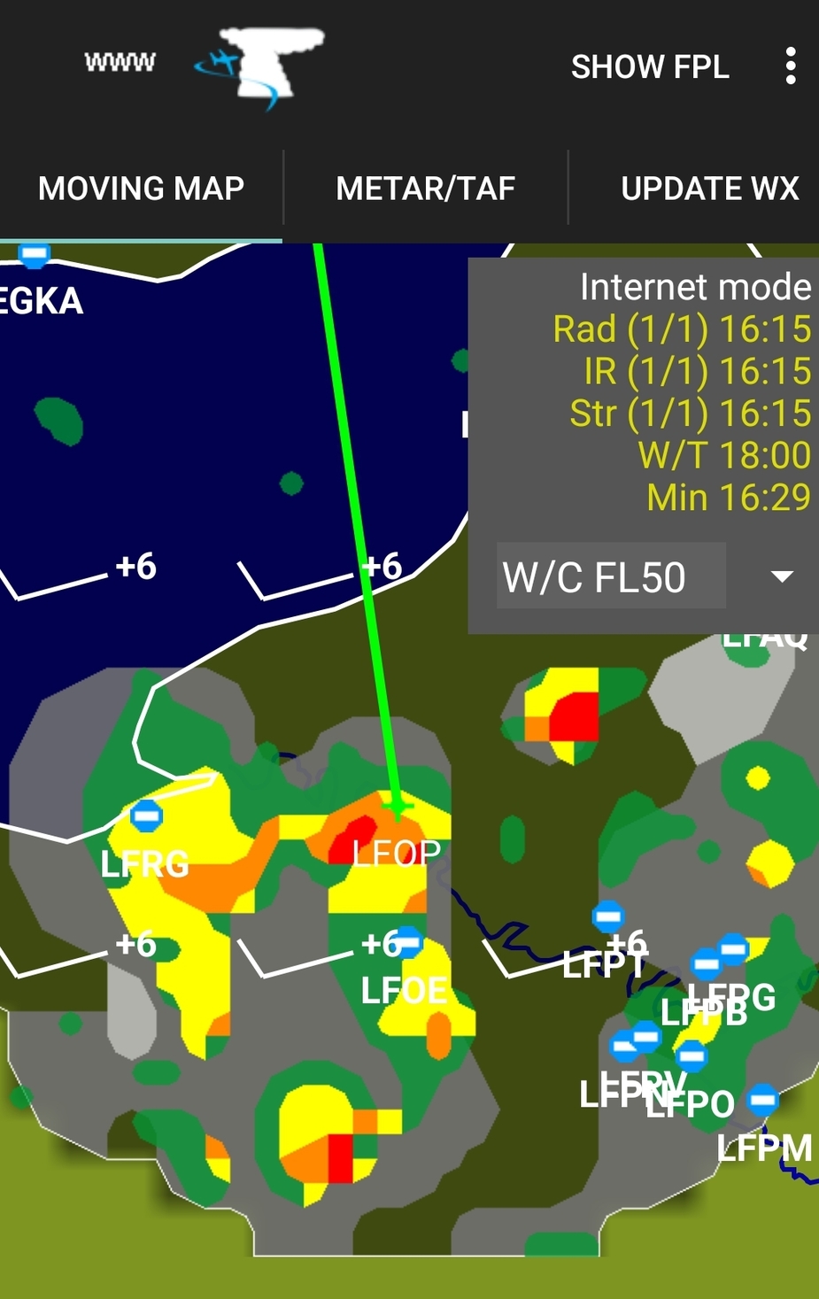
Does anyone know how far TCU, CB or TSRA in METAR or ATIS are detected near the aerodrome? 20nm? 10nm? 5nm? 2nm?
I am happy to fly with these en-route as they can be easily avoided visually or using ADL in simple airspace and terrain using extra fuel cost: the ADL + Avgas is the best weather STC out there
However, I always get nervous flying ILS/LPV with TCU/CB around and I won’t slide on procedure they are reported in the vicinity (or takeoff)
Recently, there was no TCU/CB in METAR or ATIS, however, it turned out I had one on long 10nm final, so I had to break from RNP and fly VMC around it.
ADL had it but with delay, altough it was a small one that was visible from FL80 with top at 12000ft. On the radio, I heard two gliders landing in field, one of them “wished me good luck” with a sarcastic tone