Cobalt wrote:
it will be pretty obvious that way when you get abeam the thing; the needle flicks from one side to the other with or without a brief red flag. That is confirmation you went past it.
Exactly. that is what I meant and expect, looking at the chart.
Mooney_Driver wrote:
Actually, how far off is it? Would you see a deflection?
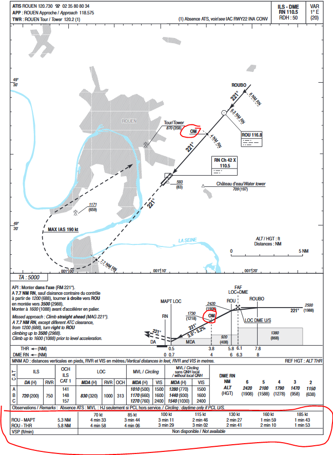
Under 1/4 dot, examiners tolerate +/-2.5 dots
Cobalt wrote:
This is safe – the purpose of the FAF is to provide an error check to catch gross altimeter setting errors, false glideslopes or misdialed nav-aids, so as long as you have that position check before you go below 2,420ft after ROUBO you don’t bust anything… you just respond that you arranged your descent to arrive at/abeam the VOR at 2,420 and were never below the profile, so there
I think that makes life more easier at Rouen…it’s a brave bold move in non-DME LOC Y 26 at Lille, you descend from 2000ft to 1380ft?
Malibuflyer wrote:
a) GPS fails, b) ILS fails and at the same time c) DME fails…I’d have ATC radar vector me to the next military airport and do PAR approach.
Well that is really unlucky  there are no radar services at Rouen bellow 3000ft and the military at Evreux & Villacoublay stopped offering PAR, nearby one is 200nm south-east at Avord…if a, b, c fails, I would just hand myself to the ground, ‘I am sorry Goose’ like in Top Gun
Cobalt wrote:
If you have a reasonable GPS, you fly timed approaches using the GPS with the primary aid (NDB or LOC) tuned to cross check. On the Garmin navigators, you would simply load the procedure, DISABLE automatic switching from GPS to VLOC, and fly it. You manage the descent the same way as you would on a GPS approach, including any vertical guidance the navigator gets you.
Well it’s not easy on this one, pressing direct ROUBO in GPS FPL, I get ‘approach not active’ no LNAV+V, the missed procedure goes missed and the GPS approach is toasted…it works if you have loaded & activate an IAF (activate ROUBO-FAF leg) or activate in vector-to-final VTF mode (removes ROUBO from extended line) and now you need glass-cockpit with 3×CDI: ROU VOR, LNAV GPS and RN LOC
The direct ROUBO (this is not an IAF) has to be done along LOC axis, ROUBO is 1.7nm from FAF, that is too close for GPS/FMS mechanics and also too short an ATC vectoring instruction
Malibuflyer wrote:
I’ve never flown a timed approach and I’m very sure I’d never do it in IMC.
If you have a reasonable GPS, you fly timed approaches using the GPS with the primary aid (NDB or LOC) tuned to cross check. On the Garmin navigators, you would simply load the procedure, DISABLE automatic switching from GPS to VLOC, and fly it. You manage the descent the same way as you would on a GPS approach, including any vertical guidance the navigator gets you.
To cross check you should set NAV2 to show the localiser, but keep the NAV1 indicator on the GPS.
But that answer is boring…
Ibra wrote:
Do you have to overfly VOR or stay on LOC?
Mooney_Driver wrote:
Actually, how far off is it? Would you see a deflection?
Looking at the chart, it appears to be less than 0.2 miless off the centreline. So the localiser path leads through or is close to the “cone of silence”; in practice I would (a) look at the moving map; or on legacy dials, (b) set the VOR receiver to a radial 131 or 311; it will be pretty obvious that way when you get abeam the thing; the needle flicks from one side to the other with or without a brief red flag. That is confirmation you went past it.
I’ve never flown a timed approach and I’m very sure I’d never do it in IMC. If I’d really be in the situation that a) GPS fails, b) ILS fails and at the same time c) DME fails, I’d have ATC radar vector me to the next military airport and do PAR approach.
a, b and c have already sufficiently demonstrated to me that this is for sure not my lucky day so that I’d not bet my life on having luck with such a timed approach.
In reality – you use the GPS to fly at 2,500 towards ROUBO, intercept the localiser, then descend with the glidepath. If you have a DME, you cross check at intercept / D6.3 and D4.0; if you don’t have a DME you cross check at the VOR; it won’t be precisely at 2,420ft because you will be in/close to the dead cone above the VOR.
This is safe – the purpose of the FAF is to provide an error check to catch gross altimeter setting errors, false glideslopes or misdialed nav-aids, so as long as you have that position check before you go below 2,420ft after ROUBO you don’t bust anything. In theory, you should descend imediately to 2,420 from ROUBO, so if an persnickety wannabe-examiner points that out, you just respond that you arranged your descent to arrive at/abeam the VOR at 2,420 and were never below the profile, so there…
The non-DME LOC is a timed approach. The localiser should be intercetpted at ROUBO; but the missed approach point has to be determined by timing. So you start your descent above / abeam the VOR and start the stopwwatch, then descend with a ROD appropriate for the GS and go missed at the appropriate time – both the ROD and time are helpfully on the plate.
If you start at 2,420 and fly the rightt ROD, you should be exactly at the minimum when you hit the time. If you arrive at the minimum before the time is out, you can level off or go around; but you must go around when the time is out.
Presonally – with no DME, this is an approach that will work better if you don’t mind a bit of “dive and drive”: You choose a slightly higher descent rate, which leads to a level off at the minimum ahead of the time running out; unless that ROD is silly you will not bust the interim step-down minimum of 920’. But that is a matter of taste.
Ibra wrote:
There is an Outer-Marker OM ground station, see AIP plates, we hiked nearby once but usually it does not ring in my cockpit GMA
Ah, ok, then it’s easy. Simply why don’t they put it in the chart…
Ibra wrote:
Do you have to overfly VOR or stay on LOC? and which one you set as primary guidance?
I would say stay on the loc, like on the ILS.
Actually, how far off is it? Would you see a deflection?
Those IM, MM, OM are usually missing in the plates or not working…I even wonder if they are really required for approach? and how they are treated for substitution?
Ibra wrote:
There is an Outer-Marker OM ground station, see AIP plates
It’s odd that it is not charted on the Jepp plate.
There is an Outer-Marker OM ground station, see AIP plates, we hiked nearby once but usually it does not ring in my cockpit GMA
Let’s get the obvious out of the way: the ILS can be flown without DME, the integrity of glide path can be validated by VOR and OM
Now for LOC/VOR, without DME, I sure less sure about the following:
Do you have to overfly VOR or stay on LOC? and which one you set as primary guidance?
Any change in minima? 2D NPA approach without DME is probably named ‘timed VOR/LOC’