greg_mp wrote:
some of my instructors did tell me that even if you have your own mean of getting a good weather briefing, have just a look on aeroweb with your own login
I am sure that was the case few decades where one had to use the national weather service (telephone pre-2000 & website 2000-2010), this is no longer the case in most countries but I was surprised to hear a similar thing on F214 & F215 forms, when digging nothing did come out of it: “ogni sacarrafone è bello a mamma sua” (“every cockroach is beautiful in his mother’s eyes”)
I found the representation of frontal systems very poor on Windy..Is there a way to get this visualized with a forecast time laps like the old charts?
I second this question.
Agree, no fronts on windy. Apart from isolines + rain layer.
I use this but it’s static (free from austro control).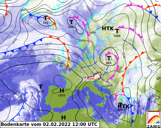
I use windy.com for all wx briefings. It has revolutionised flying wx. It presents the European ECMWF model which is the best out there; all this stuff was “top secret” until just a few years ago (because the met offices sell the data to commercial wx data repackagers) forcing GA to brief from the free US GFS model (which still today is presented by most free wx websites; they mostly rip it off each other  ) which is not so good for Europe. It also presents ICON which is almost worthless, so watch out!
There have been many very pretty wx sites but the data was usually garbage. Some notes here (the old crappy Meteoblue) and here from the pre-windy.com era and here for cloud tops (I still use the IR images).
Regarding fronts, these are drawn by hand so won’t appear on automated websites. But what really matters is the 3D weather and that’s what windy.com gives you. If you really want to see fronts there are sites which present the UK Met Office MSLP charts. There is also the DWD site which gives you access to these for free. DWD also does icing forecasts but they are IMHO worthless, once you see the windy.com medium cloud extent (medium cloud is most applicable to GA, except for approaches and for VFR flying when low cloud obviously matters too). However, fronts can be misleading unless you really are an expert who does this for a living.
Plus of course METARs and TAFs. TAFs are done by professionals, after they see a METAR produced.
Many other great threads on weather – example.
Europe has no “legal” wx briefing sources for private flying. This may exist in some countries as an invention by their local CAA. This also extends to “FIKI” which is a US term which maps onto specific (US) wx sources and has no legal meaning (in the sense of getting prosecuted for a criminal offence if you depart) outside the US.
Actually I have heard that BEA is checking that PIC did check the weather through its account when studying an GA accident.
which is, of course, outrageous
Snoopy wrote:
I use this but it’s static (free from austro control).
I really like the sat image with the fronts drawn over it. I wish they would’ve shown us in PPL met class because in these you can actually see what fronts mean in respect to cloud coverage. But on the other hand: Does it really make sense to use that little theoretical knowledge (like fronts) which one gains when doing the PPL for real flight planning? During PPL training I mostly used METARs and GAFOR supplemented by a little bit of Windy (satellite and radar images for short term planning up to maybe three hours and mostly cloud base and wind forecast to decide in the morning whether a trip in the afternoon will be possible). I quickly developed a feel for these tools and still use nothing else. I now also look at Skydemon but I don’t use it for decision making since I still don’t fully understand/trust it.
For day trips, I don’t believe that I’m missing out on some superior tools but I wonder if it would make sense to learn a little bit more about weather and to be able to at leat interpret traditional weather charts (forgot most about it few days after the exams) for planning longer trips. Right now I would resort to my usual tool collection and I don’t think I will ever be able to outforecast these tools by myself. So I wonder if it would really make sense to invest the time. A little bit, I feel less of a pilot because I lack these skills (can’t use an E6B as well) but my kids also will never learn how to use a rotary phone dial and couldn’t care less.
I remember the big hubbub when fronts were removed from the standard SWCs. The reason was, most SWC’s start at FL100 these days and therefore any front position would be inadequate, as they always represent the frontal lines on the ground.
there are plenty of sites where you can actually get fronts displayed, one of the easiest to use is this one here:
https://www.dwd.de/EN/ourservices/hobbymet_wcharts_europe/hobbyeuropecharts.html
This one gives you frontal charts for the next several days. It also gives you a current analysis which is also kinda neat.
Most automatic charts don’t do fronts, because they never are done automatically (well, KNMI does some but the result is sometimes a bit weird)
With a bit of practice you can see the fronts fairly well after a while on sat pics as well as on pressure and precipitation charts. They are also still on some LLSWC’s such as TEMSI/EUROC, which I still think is one of the best charts for all of Europe. You can get it here, just click on “Cartes” and download the PDF.
I, too, am pretty impressed with Windy. I sometimes pretend I’m flying to a remote place with a webcam, check the Windy forecast, and then come back a few hours later to see if the webcam matches the forecast. It usually does.
Last week coming back from Spain it showed I would not be able to land at my home airport in CH, and I figured “let’s try it anyway, there are other places I can divert.” It was right, and I needed to divert. I should have stayed an extra couple of days in sunny and beautiful Spain.
I agree, Windy is #1 weather information site. There’s a huge amount of information to be obtained from it. But especially if you plan longer trips you still need a lot of knowledge to correctly interpret the data you see. The output that is shown in Windy is very enthusiastic regarding the level of correctness of the forecast, where it is in fact impossible to achieve such a degree of detail. For example, cloud layer forecast in frontal clouds is bull**it. It may be as forecast, and it may be totally different.
But you can compare, within Windy, at least 5 different forecast models and can figure out how reliable the data might be that you get.
I miss the times where you had the phone number of a human being who really knows about weather (or even had such a person on the field) and could discuss your plan with them.
Windy and co are great tools with loads of information. But as Mooney (I guess the only real expert on this topic here) pointed out in an earlier post: It is actually extremely difficult and takes a lot of knowledge to actually interpret what all of this means. Too much of knowledge for an average 20hrs/year amateur pilot…
Therefore those tools are perfectly fine for a short hop in my local hood – but as soon as it gets in unknown territory it is getting difficult. And the risk of complex data being presented in such an accessible way is always that it creates false confidence because I believe I understood something that I haven’t.
Same challenge with the (at least in Germany) very popular Gafor: If everything is blue or green it is about fine to go. But as soon as some yellow comes into the game the data is so difficult to interpret that one typically fails – and yes, there have been fatal accidents where it was a likely contributing factor that the pilots were not aware that even though Gafor is yellow there can be clouds to the ground…
It’s not just weather forecasts that one needs to consider one should also include weather patterns in geographical conditions.
Eg You are flying up a valley in the alps on a beautiful sunny afternoon, where is the wind likely to be coming from?
On the coast you have the Brise de la Mer and the Brise de La terre.
Over a Marais afternoon haze can make spotting an airfield, let alone a grass runway very difficult.
And what about landing into the sun.
Then there is fog which cannot always be forecast, in fact sea fog and mountain fog can be very difficult to predict accurately .
The same goes for flash floods in summer.
So there is more involved than just reading somebody else’s interpretation of a forecast.
From my position in South Est of France, it’s actully very difficult to predict the weather. We are always between Italia’s depression, AntiCyclon in Spain and they are fighting all year long depending on the atlantic flow from the west and the alps on the north, which gives something quite a bit unpredictable. This is also the case with windy with most average weather. What we know is when it’s predicted to be crap, it is usually but between 1000ft and 10000ft, we are never sure. Fortunately, most of time it’s very good.
The resulting wind is always uncertain, we can have sometimes 25kn east abeam Nice, and 30kn abeam Cannes. I flew in there once, it was very bumpy of course…
For this reason, I am very doubtfull for all local weather prediction, including windy. But I admit for the rest it’s accurate, including in the mountain areas.