eurogaguest1980 wrote:
I don’t yet know the exact crash location, but you don’t need any software to know if you can fly or not.
One information I read is “near SW” which would be somewhere near Grand Sommartel. That hill is roughly 4400 ft high.
eurogaguest1980 wrote:
I’m holding my breath until I find out who the victims were, since this is such a small community, there’s a painful chance I know some. :(
It looks like it was a sight seeing flight booked for 2 pax. One of them has been identified as Valentin Petit, a movie director from Bourges, France and a second person in their 30ties. The pilot is referred to as being from Neuchatel and in his 70ties.
Besides weather apps, navigation apps allow you to plan and fly with terrain warnings / situational awareness. However, you often need to activate it separately (at least in Skydemon) to see the red-colored terrain. In case of an emergency, it might save your life, while flying VFR into IMC. Also, the “Flyable Conditions” forecast in Skydemon is pretty useful, so you can check where to expect VMC or IMC conditions. Sure, it’s just a forecast, but after some improvements within the last year, it does a pretty good job of providing a general overview, which you can compare in detail with apps like Windy or Meteoblue. Not to cheat and search for a “better” forecast, but to check if they expect identical or similar weather, plus further details. Windy for example has a lot of webcams, where you can check the actual conditions quite easily. Especially at aerodromes or mountain passes, including meteogramms. And last but not least, the final reality is what you see on-site. If it doesn’t match with the forecasts, act accordingly.
It’s however pure speculation if the pilot has used such tools or not, or if he was familiar with the area (also in bad weather) or not. I’m however convinced that these tools bring more safety, compared to a few incidents, in which pilots used the apps wrong or misused them to fly in questionable weather.
It remains a very tragic incident. :-(
I know that area pretty well, having done my flight training there. I don’t yet know the exact crash location, but you don’t need any software to know if you can fly or not. If clouds are low, and you can’t see over the mountains, then you will be in IMC if you try to get to the other side. I know the temptation is strong. You can easily drive over the pass and know exactly how thick the layer is. I’ve done it literally 100s of times. If you drove over that pass on your way to the airport, you might say “heck, it’s only 50m thick – I can punch through it!”
Very tragic – the days following this crash have been generally beautiful flying weather. I’m holding my breath until I find out who the victims were, since this is such a small community, there’s a painful chance I know some. :(
gallois wrote:
Is it me or is it despite all this new easy weather software so many pilots do not seem to know how to use it...Its almost as if ga pilots have gone backwards in aviation weather forecasting despite the better tools.
No, it’s not you. That is quite true.
The problem with tools is always the same: If you are given a new hammer, chances you’ll smash your finger using it are quite real.
The main problem I see with the fancy tools available, particularly the free ones, is that they are based on rather large scale models, particularly the free tools but also some others. Working models is a science in itself. And therein lies the rub.
The use of those tools like Windy, Ventusky and others instill a false confidence. Actually, in both directions. Forecast models all have their strong and weak points. Knowing which one is the main thing meteorologists today have to deal with in their daily work life. And believe me, it’s not easy. The more models turn up, the more confused things become. It takes ages to even remotely understand which model is good for wind, which for rain, which over – or understates cloud, under which conditions. And once you get it figured out, they change a parameter and splash : The mud flies into your face by the bucket.
With people who are not doing this for a living, the story is slightly different. There are several aspects.
Human: People are great in cheating themselves, particularly if they want something. So quite often, they will look at 10 apps for a forecast and then take the one which is closest to what they want. Not the best, but just the one which will satisfy your desire to go flying, surfing, camping, mowing the grass. Only to find out that oops, that particular model just did not quite hit the jackpot that day.
Expectation: People have totally unrealistic expectations in terms of accuracy. And with always more ridiculous claims of apps being able to forecast 14-21 days, people believe whatever they read, hook, line, sinker, worm. The same happens with convective forecasts: You see folks who watch the “radar” image, which in the future shows a model, and take the blops on that screen as a 100% location forecast. It is only once they rescue their Bratwurst out of the swimming pool that they realize that TS forecasts which are more than 15 minutes into the future say only one thing: There will be TS in your area, but where, we will tell you after they’ve passed.
Maybe I’ll write down some of this stuff once I retire, but for now I hope this gives you a bit of an answer why the shiny tools have their huge advantages but more catches than the average mine field.
(And just to add to the headache a bit: Models base on observation and measurement data. If those are crap, so will the model output. Currently, observation stations all over the world get “converted” from humans to machines. Which means that quite a few synoptic observations cease to exist and the METARs which get produced are, well, I shall take the 5th on that subject. So without human observers, who still know the difference between a Alticumulus with a pedigree of a 15000£ foxhound and a Cumulonimbus brachialis terribilis (no don’t look it up, I just made that up, but look below and you get the idea), what will your expectations be? )
I took the pic of that little gem right over ZRH a couple of years ago. Needless to say, below that, some insurance agents got busy a few days later. So that is about my definition of the above mentioned CB, even though it’s genuinely benign in comparison to some I’ve seen elsewhere.
boscomantico wrote:
Speculation. It would mean many pilots would enter clouds (unless of course they turn around once they see that maintaining the MSA might take them into clouds, but we know that people will not do that and they will rather descend to remain outside of cloud). So, when phrased like this, descending to stay below clouds is, for that moment, possibly the safer thing to do than to maintain MSA.Remember that in Europe, only a few percent of GA pilots have real instrument flying skills. Likely several percent more in the UK (due to the existence of the IMC rating).
Yes but in many of these accidents the VFR pilots do enter clouds. At that point if you’re not IMC proficient you should either turn back or at least follow MSA rather than gamble that there’s nothing in the way.
gallois wrote:
Is it me or is it despite all this new easy weather software so many pilots do not seem to know how to use it.
Its almost as if they look outside and at one of these sites and think its okay now its going to be okay for the next hour or so however far away the destination.
I have no idea what this pilot used, but often enough for a local flight, people simply don’t look far enough. In this case, the danger of getting into IMC should have been visible from the ground.
The METAR for the time of departure gave 06007KT 030V100 BKN011 BKN013 09/08 Q1015. The TAF valid for that time indicated BKN013.
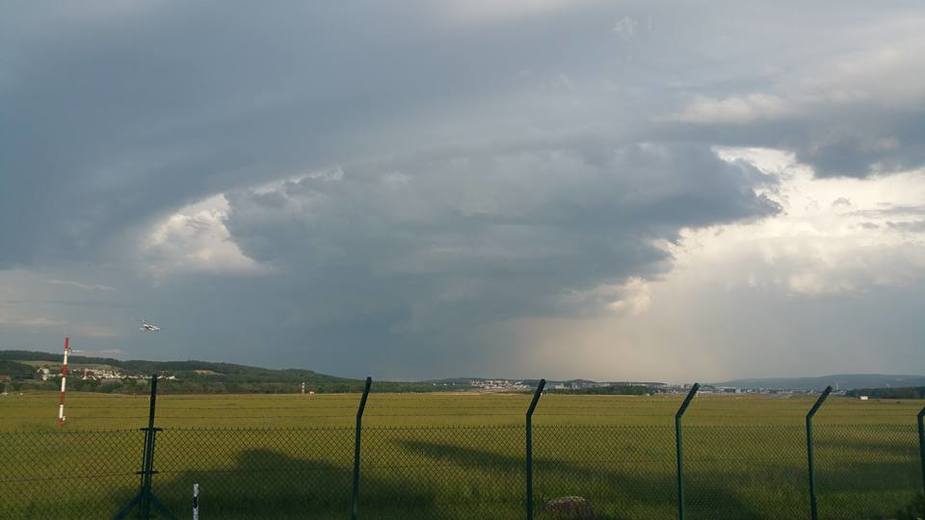
LSGC is 3368 ft elevation, so the ceiling at the airfield was 4400 ft AMSL. The hillside they crashed into was at 4400 ft. Also there was a web cam picture from that day, which showed that at 4500 ft was total IMC. Also in the airspace D he flew he would actually need 1500 ft AGL… this was definitly not given.It should not be necessary to use expert systems or even the internet tools to make that determination. He must have seen that the tops of the valley left and right of him were in clouds.
Speculation. It would mean many pilots would enter clouds (unless of course they turn around once they see that maintaining the MSA might take them into clouds, but we know that people will not do that and they will rather descend to remain outside of cloud). So, when phrased like this, descending to stay below clouds is, for that moment, possibly the safer thing to do than to maintain MSA.
Remember that in Europe, only a few percent of GA pilots have real instrument flying skills. Likely several percent more in the UK (due to the existence of the IMC rating).
If pilots religiously calculated the MSA for every leg of their flight and flew above it when entering MSA it would prevent a lot of accidents of this sort.
Is it me or is it despite all this new easy weather software so many pilots do not seem to know how to use it.
Its almost as if they look outside and at one of these sites and think its okay now its going to be okay for the next hour or so however far away the destination.
Its almost as if ga pilots have gone backwards in aviation weather forecasting despite the better tools.
The crash did indeed occur at 1020 LT. It was a Robin DR400-180, HB-EQD, out of LSGC with 3 POB.
From what transpires, the crash occurred shortly after departure in most probably IMC conditions at the crash site. The Jura peaks were in cloud and the airplane ran into a wooded hill right up there.