
It's interesting to note how this has been changing over the years.
A "must" is mobile internet, for weather, notams, contacting airports, etc, and it has been a "must" since I started flying abroad in 2003.
But back then I used a Nokia 6210 phone connected to a laptop via an RS232 cable, with a 9600 baud dial-up connection to my home ISP 
To be fair I could send faxes with that which was almost essential for PPR/PNR for some airports, and remains very useful today, in the corners of Europe.
Today, one could do everything with a tablet e.g. an Ipad. I would consider the Ipad a struggle for a lot of the non-flying stuff (due to it being so locked down on functionality) but there are two real issues with it for flying:
Eurocontrol IFR route development - for this there is no IOS solution and the only web solution I know of is Rocketroute. EuroFPL (which is what I use for flight plan filing) offers access to the Eurocontrol "route suggest" feature which is better than nothing but often doesn't work at all
European VFR moving-map-GPS maps - there are probably piecemeal solutions with different products for parts of Europe. I am sure the Germans have one. For the UK there is Memory Map. I don't know of anything that runs the Jepp VFR/GPS charts. There is a large amount of bootleg maps around (an activity fuelled by the very restrictive nature of European map publishing) but with no Oziexplorer for IOS, the Ipad remains limited. There is Ozi for Android, however
Difficult to connect to satellite phones for in-flight tafs/metars etc. Solutions do exist but are all messy or unnecessarily pricey, relative to what a Thuraya satellite phone can be obtained and operated for these days
Apart from the above, one could do everything with a decent smartphone, too.
The fax bit one solves with a fax2email and email2fax service. I know people laugh at fax nowadays but if you fly to Corfu LGKR (24hrs PPR, though the man in the tower thinks it is 5 days PPR) they still fax you the permission with a big rubber stamp on it Since LGKR will refuse landing to traffic without the permission (just for the laugh, seemingly) I quite like to see it for real.
On longer trips, I take a lightweight laptop (winXP) which of course does "everything" but is not usable during flight. The obvious next step - convertible tablets - are all too bulky.
I have just started playing with the Lenovo Tablet 2
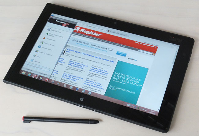
which - apart from running the utter piece of crap called Windows 8 - should do "everything". It is of similar size and weight to the Ipad and - this is a first as well for non Apple tablets - approaches the quality of its finger interface. It runs all the usual stuff and I have a VM on it (thanks Achimha ) under which I can run winXP. Win8 is OK if you just set it up and use as a touch device, which it does well. After all, it is the apps that one uses a computer for
Crucially, it runs Oziexplorer so you have access to all maps going, and should run FlightPlanPro for IFR routing though I have not got around to that yet. It should also support dial-up networking for the satellite phone, though again this is not going yet, due to some COM port / modem issue. Underneath it is simply old Windows; probably close to win7.
It has a built-in GPS but, like the Apple implementation, it doesn't work with any old apps, because it does not generate NMEA. It has a new API which, again like Apple's, hides the satellite constellation from the app so all the app sees is lat/long and a few other bits. Oziexplorer does support this new "win8 GPS" API and it does work though time will tell how reliable it is in an aircraft (the Ipad2 is very marginal in the TB20).
I think this tablet removes the need for an Android tablet, completely, and certainly removes the need for an Ipad. Windows does run literally everything...
The plan was to mostly leave this in the plane (as I do with the LS800 which I have been using since 2005) but it is actually usable enough for chucking into the backpack, for an overnight trip.
I wonder how other people have solved this "travelling IT" requirement.
Eurocontrol IFR route development - for this there is no IOS solution and the only web solution I know of is Rocketroute. EuroFPL (which is what I use for flight plan filing) offers access to the Eurocontrol "route suggest" feature which is better than nothing but often doesn't work at all
RocketRoute is fully supported on the iPad, there is an app although you can also do the same via the website. You need online access anyway because the whole business is based on probing routes against the Eurocontrol computer. I have planned complex IFR flights entirely on the iPad on the road.
It has a built-in GPS but, like the Apple implementation, it doesn't work with any old apps, because it does not generate NMEA. It has a new API which, again like Apple's, hides the satellite constellation from the app so all the app sees is lat/long and a few other bits.
There is definitely another API in addition to the abstract Windows 8 location API. You need to find out the make of the GPS chip and then look for apps. But why would you be interested in the constellation? The Windows 8 location API supports accuracy (meters) which is all I need.
Difficult to connect to satellite phones for in-flight tafs/metars etc. Solutions do exist but are all messy or unnecessarily pricey, relative to what a Thuraya satellite phone can be obtained and operated for these days
Wait until I am done with my GmPRS Thuraya setup. My BOM is rather high (Thuraya XT 800 €, Car holder €300, Wifi hotspot €350, external aircraft antenna ca. $500 but I didn't pay for it  ) but I think it can be done for much less by eliminating the car holder and going for a € 35 wifi hotspot. Now that I got them and have them disassembled, I know what they do and how to do it for next to nothing. Stay tuned...
You need online access anyway because the whole business is based on probing routes against the Eurocontrol computer.
Yes; FPP uses an internet connection too, but FPP is free
Also I don't like web based flight planning resources because they can use up a huge amount of roaming data.
You need to find out the make of the GPS chip and then look for apps. But why would you be interested in the constellation? The Windows 8 location API supports accuracy (meters) which is all I need.
What would be good is an NMEA emulator, which would then work with every app. These have been done, for other platforms, presumably due to the outcry from people wanting to use their existing GPS apps. I gather ASUS have done one for their tablets.
The satellite data is good to see to e.g. check for why you aren't getting a fix. For example yesterday I very quickly diagnosed a duff BNC connector on the G496, by looking at the instantaneous signal levels. You can't do that on an Ipad, which works.... and then doesn't .... and then again does.
I am definitely staying tuned for your setup, but I still want to use my 7100 phone (I have 3 of them, all bought cheaply) which works only via the serial cable. The need for in-flight wx is IMHO very sporadic.
•European VFR moving-map-GPS maps
What about SkyDemon?
What about SkyDemon?
Last time I looked, which was when I was speaking to one of their reps a few months ago, it didn't do Croatia and Greece. He asked me if I would mention it in my writeups; I said I might if they give me a free copy (I use Navbox myself, as it covers all of Europe so one less thing to worry about) to which the reply was they can't afford to.
Their maps are not the official VFR charts; they are synthetic representations of data they obtain from various sources and to which the app applies various declutter rules - see e.g. here. Whether this is an issue is a matter of opinion, of course. It probably depends on how you use the product, how (or indeed if) you pre-plan your flights, etc.
For Greece, there are no official VFR charts anyway but a group of pilots got the last ONC charts and marked them up from the Greek AIP etc. I have these scanned and running under Oziexplorer, too.
Interesting....
It's interesting to note how this has been changing over the years.
I would instead say: Interesting to see, how nothing has changed since I started flying commercially in 1992!
A "must" is mobile internet, for weather, notams, contacting airports, etc, and it has been a "must" since I started flying abroad in 2003.
For us, mobile internet is mostly useless, as we are still required to document everything on paper. But at least almost every small airfield has some kind of (self-)briefing station now, where weather and notams can be downloaded and printed without endless phonecalls and half-hour waits for slooooow faxes.
But hopefully, some time later this year, our company will get the approval to switch from paper Jeppesen to iPad Jeppesen... Until then, I carry my iPad with me solely as my private communication device.
For us, mobile internet is mostly useless, as we are still required to document everything on paper.
I don't see any conflict there. I fly with paper myself.
But one needs the internet for the preflight briefing, doesn't one?
Unless flying with an ops department which does it all for you.


