
Ibra wrote:
Nice one on cyclist routes, it may work for Category 0A flying: Cubs & Maules
In this case the cyclists may over take you 
Ibra wrote:
Nice one on cyclist routes, it may work for Category 0A flying: Cubs & MaulesThe biggest risk of going in lower altitudes is computational complexity & over navigating, a software can enter a dead end and roll back, a pilot is pretty much dead if he enters a valley at the wrong height, the deadly mistake usually starts 50nm ago where he should gone right instead of left or climbed…
I think flying at constant planned amsl altitude is the right thing to do, rather than 1000ft agl, any hope of out climbing terrain will fall short as one gets 2% climb gradient, which is 2D for practical flying near 3D terrain, unless you have an afterburner, I can’t see how one can maintain 1000ft agl even with an AP on Radar Alt mod
Fully agree. I’m not interested in imitating terrain following radar ops in fighter jets. It’s more a theoretical thought exercise (finding a software that can do it) and could be applied for preflight planning. I’d rather fly over a route with low terrain, with which I have familiarized myself with well than plan 9500ft and hope for the best.
Ibra wrote:
I think flying at constant planned amsl altitude is the right thing to do, rather than 1000ft agl, any hope of out climbing terrain will fall short as one gets 2% climb gradient, which is 2D for practical flying near 3D terrain, unless you have an afterburner, I can’t see how one can maintain 1000ft agl
That’s surely right when its possible. On some of my say 60-90 minute flights across mountains I am either climbing or descending for perhaps 75% of the flight. The route is dictated by climb angle performance, with departure and destination airports close to the mountains on both sides and only a few hundred feet above sea level.
Silvaire wrote:
On some of my say 60-90 minute flights across mountains I am either climbing or descending for perhaps 75% of the flight
Yes if one starts with good margins and can turn tightly, they can increase/decrese altitude margins as things go, especially in Piper Cubs !
Far more fun in gliders it’s 100% up & down in mountains & valleys as long as as lift is generated, if one is flying at +120kts turn radius on min height to obstacles (VFR 500ft & IFR 2000ft) it will get tricky, even more if they add clouds & winds
LeSving wrote:
The solution is called a large paper map Seriously, this is precisely the kind of thing that’s easy to do on a (good) paper map, but almost impossible with an app. You may not get the optimal solution with paper, but that’s much better than no solution at all. There are other maps with good info of the terrain that can be used, but you still have to study it first and “transfer” the route to SD or similar.For instance. This area is darn cool to fly in and out and up valleys and through passes. This is what you see in SD:
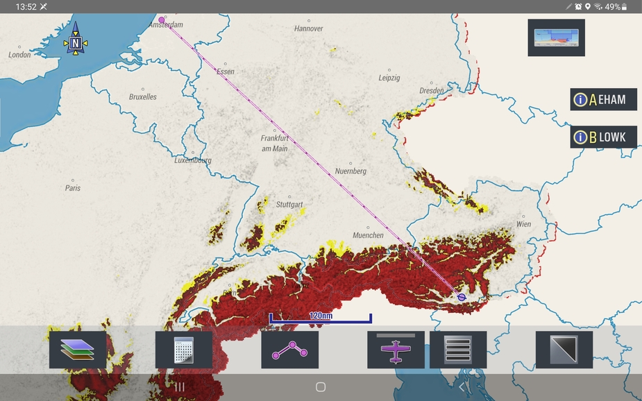
You’d be surprised what you can do with SkyDemon. For one thing, it offers different chart styles. But most importantly, you can turn on various kinds of terrain information. In SkyDemon plan, go to "Mapping"–>"Terrain and Surface Features" and turn on “Show Terrain”. Then you get this:

Even better, go to "Mapping"–>"Terrain and Surface Features" –>"Colour High Terrain" and select your desired flight altitude. Then you get something like this:

In this case, I’ve selected 4000’. The red/orange/yellow/uncoloured areas give you a terrain clearance of <500’/<1000’/<1500’/>1500’ .
I would argue that working in this way is much easier than using a paper map.
Airborne_Again wrote:
I would argue that working in this way is much easier than using a paper map.
Easier for what? You still miss lots of information that is displayed on real maps. When flying “into” the terrain, it’s important to know the gradients, so the terrain won’t outclimb you. What SD will tell you is what the minimum alt must be, given you are flying at one single altitude. It doesn’t tell you what AGL you need to be at an arbitrary position to make sure the terrain doesn’t outclimb you. Climb gradient are of main importance.
Ambulance helicopter pilots fly like this all the time. I wonder what they use, but I’m convinced they know most of the terrain by having studied maps and through experience. A helicopter isn’t “hampered” by climb gradients though, so it is a considerably easier task. The main danger for them are wires and other man made obstructions.
I don’t know, maybe FS2020 is a better tool?  At least it has a good “map”, or so they say. Google earth?
LeSving wrote:
It doesn’t tell you what AGL you need to be at an arbitrary position to make sure the terrain doesn’t outclimb you. Climb gradient are of main importance.
Neither does the paper map. You must measure and calculate. Much easier with a tool like SkyDemon.
Airborne_Again wrote:
Much easier with a tool like SkyDemon.
You do it your way, I do it my way
In gliders, one has to resist the temptation of flying toward lower terrain with risk of losing wind strength instead of going toward high terrain and use ridge & string wind to outclimb vertically, the mistake of following low terrain may end up in dead ends with calm winds, the technical term is getting stuck in “local minima with no lift”
Terrain color views like one in SkyDemon does a pretty good job is keeping track of the global picture but I think nothing will substitute some of the local knowledge
Snoopy wrote:
It looks like easy VFR is a good option. @dublinpilot could you please post a pic showing 3200ft, I’d be interested in the areas that have no shading. Thanks.
Hi Snoopy,
Unfortunately I can’t set it for exactly 3200ft. It’s set in 500ft increments. So I’ve done it as 3500 and 3000ft for you.
Here is 3500ft. Remember anything red, you’ve less than 500ft ground clearance, yellow you’ve less than 1000ft ground clearance, and clear you have more than 1000ft ground clearance.
This is 3500ft zoomed in on the Alps:

This is set at 3000ft:

This is set at 3000ft zoomed in on the Alps


