Due to the conversation about food and fuel with the recommendation of the restaurant at LFMV I was just looking at the terminal charts / approach plates for it. They haven an ILS on RWY 17 and something strange for the opposing direction.
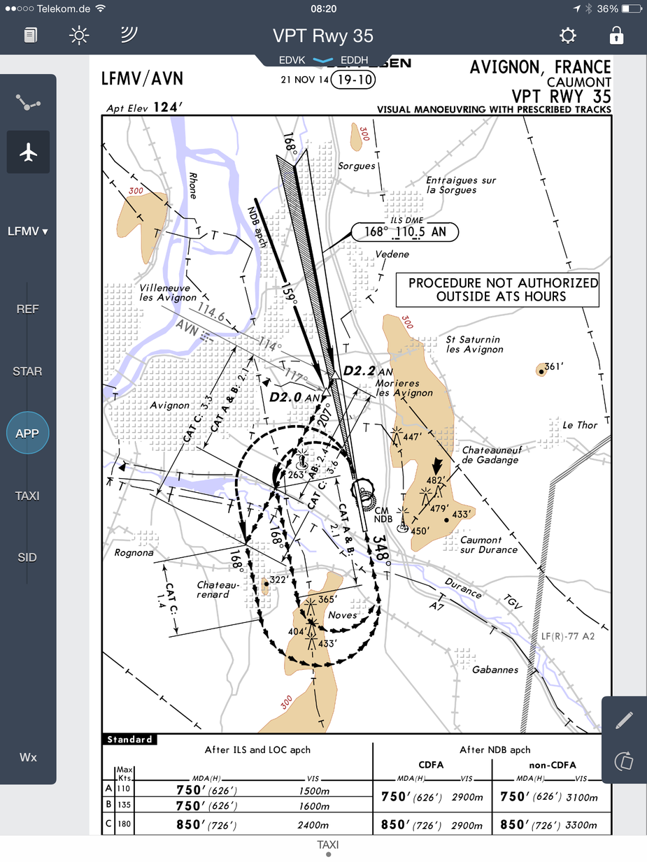
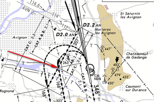
How is one supposed to fly that? I understand that one breaks off the ILS at D2.2 AN on a heading of 202. But then? I assume the ground distance for category A aircraft to the turn point into the downwind is 2.4 NM but how am I supposed to determine that?
That’s a standard circling with prescribed tracks.
How about looking at ground features? You need to be visual during that portion anyway, and the Durance seems quite a good landmark. Or you could use your stopwatch.
It seems like the syllabus of your training organisation has some room for improvement…
From D2.2 you simply fly a track of 207 for 2.1 miles. Then you turn left and track 168 for another 2.1 miles before turning base to final. The first 2.1 miles is the distance from from D2.2, the second one … I would simply turn left abeam that tower on the chart, I guess
I would probaly track 207 to the river, 168 to the first tower and then turn base … all this is flown in VMC anyway, so no big deal.
AVN 131 degrees @ 7.86NM.
It seems like the syllabus of your training organisation has some room for improvement…
That’s a pretty unfair comment. I don’t know if you understand all IFR approach charts immediately. I certainly don’t.
Well, all European IR training could use a complete overhaul. My JAA IR ground school, done at GTS in Bournemouth, was almost useless. We did route development using airway charts which has not worked in Europe for at least 15 years… but there isn’t anything one can do about this. I seriously doubt there is a single ATO in Europe which spits out pilots which can fly A to B in the Eurocontrol system. As for circling approaches with prescribed tracks (as in this one) that was way beyond anything I ever saw. We did however do loads of occluded warm fronts and how fast different bits of it move relative to non-occluded cold fronts in the southern hemisphere (really useful stuff). The only reason the IR training apparatus hangs in there is because 99% of its output goes on to do a jet TR (where they learn the knobs) and then sit RHS with an experienced pilot in the LHS.
The flying was just the usual banging of NDB VOR and ILS in the local area. I don’t think the UK CAA permits IR training to go outside UK airspace. I believe one guy specialising in the CB IR tried to get permission for popping over the France but last I heard he didn’t get it. With the CB IR you could do these approaches within the 30hrs of required experience, but not within the 15hrs “core” requirement which must be done at an ATO. And if you do the lot at an ATO then you can do this at all.
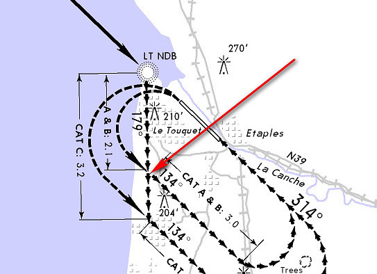
There is a similar “prescribed tracks” one at Le Touquet LFAT
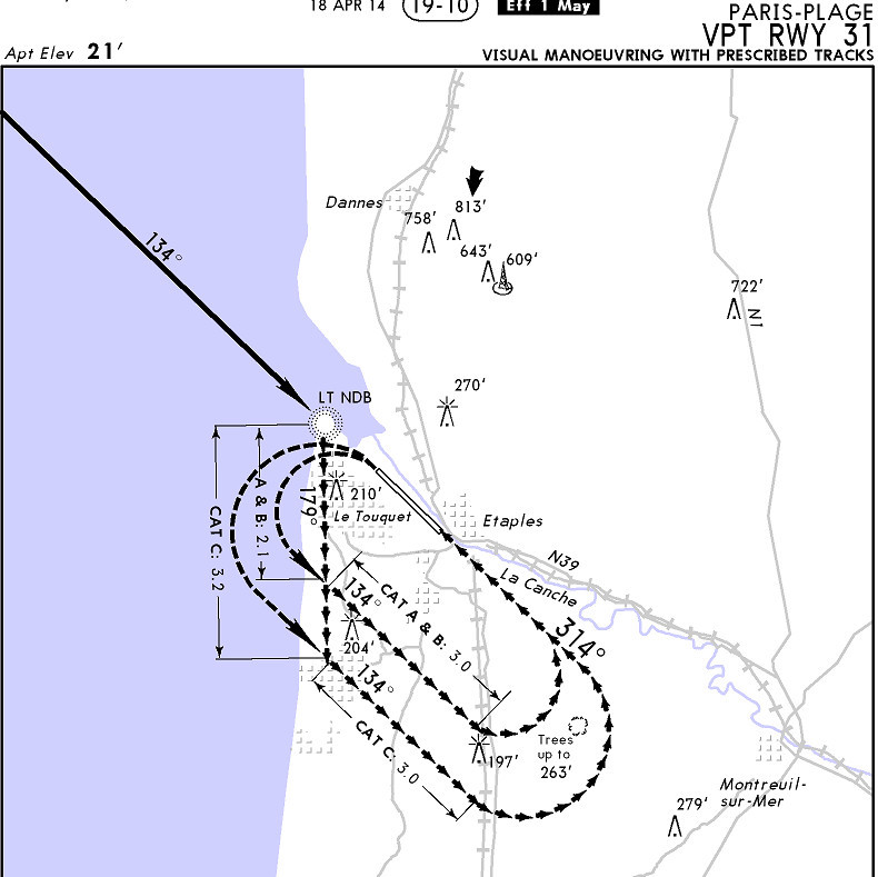
The interesting thing is that if you go there VFR the circuit is north of the runway but if you go there IFR the circuit is south of the runway.
Well, all European IR training could use a complete overhaul.
Correct me if I’m wrong, but I seem to remember that Stephan got his IR in the States…
Wherever you do it outside of Lufthansa, all you get is a licence to learn, at least that is my opinion.
I did about 100 × ILS at the same airport plus some NDBs. No GPS approach (2002) and never exitic stuff like the above. I was also never told how to use the Avionics in the best way, and the Autopilot was always broken.
Maybe there’s a school somewhere that really teaches the stuff you need in real life. Who knows.
Peter wrote:
As for circling approaches with prescribed tracks (as in this one) that was way beyond anything I ever saw.
Any pilot with a PPL should be able to fly this! IR or not.
I recall asking a similar question about the LFAT one. For example, how are you supposed to measure the 2.1nm after crossing the NDB, on the 179deg track?
Well, obviously, you look at your moving map. You set the circle to 5nm and fly 180 until the NDB is about halfway behind you, and then you turn left onto 134 
But somehow I think, ahem, one isn’t supposed to quite, ahem, be doing that… well, not on your IR checkride 
In “classical IFR” you either have every track change referenced to a classical navaid, and there a DME there as evident from the ILS chart
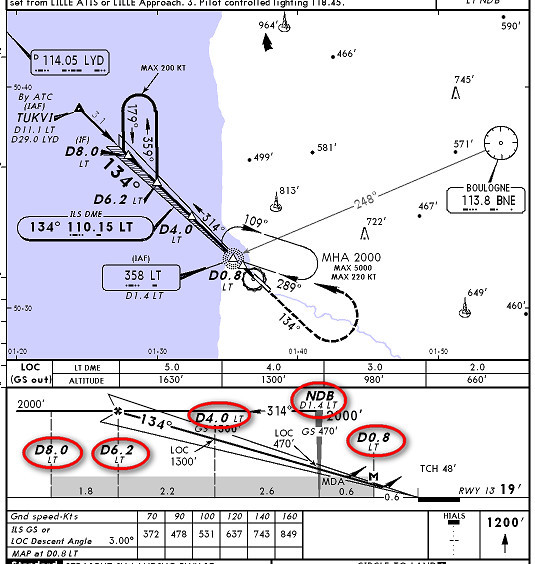
but it reads 1.4 at the NDB (LT) and god knows what it reads at 2.1nm when you are heading to one side on the 179 track…
OR it is an RNAV procedure in which case you are supposed to have a waypoint defined for each change of track.
Does an IFR GPS contain a waypoint here
or here