
Yes that's true; the SIA charts come with a separate booklet where the vertical extents are shown.
This is a bit of a hassle but the booklet also shows times of activity etc which a chart could never carry.
They do show spot heights though - see here for example. I don't know what rule they use to determine which "spot" to show the height of...
My feeling with the IGN charts - particularly the pre-2013 ones which stopped at 5000ft - was that they worked well for French pilots, particularly those who never flew very far and who "just knew" which areas would be active and when. Same comment for the UK 1:250k charts...
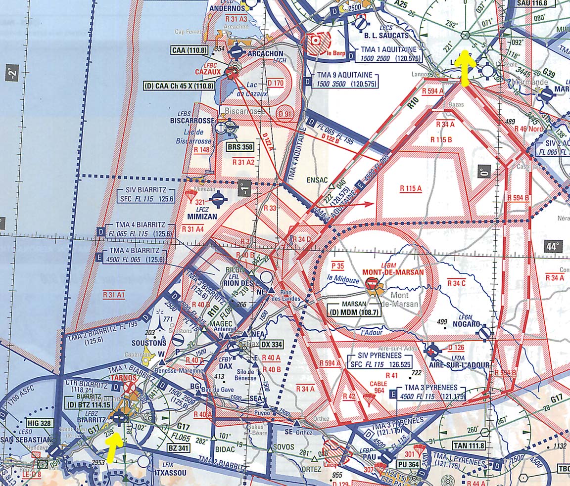
You're supposed to have a 1/500000 as well when you fly, where vertical limits are shown (beside the SIA booklet). Removing the Vertical limits makes for an easier reading. Peter, sorry but I didn't see any height on the spots of your sample. What are you referring to?
There is a 499ft point to the left of NOGARO, a 771ft tower near SOUSTONS, a 1132ft point to the right of TAN, a 955ft point to the left of PAU.
Otherwise the area is very flat.
On another SIA chart, say near MONTPELLIER, there are much higher points. But that area is also heavily colour coded for terrain.
TThierry,
My charts are on order but is it still the case that "1/1,000,000 aeronautical charts giving among other things all the informations concerning the P,Z,R zones you will cross" ? i.e. you cant see them on the half mill at all?
Peter,
Sorry, I was looking in the area pointed by the yellow arrows. Actually I have no answer to your question : why these spots and no others? they are not even the highest in the vicinity.
Piper Archer,
You can see all the P,R,D zones on a half mill chart, but there is no information about their activity, whom to contact to know whether they are active or not, or even to request a clearance to enter them, or what kind of restriction or danger you face. They want you to buy the mill chart as well, so they split the information.
They want you to buy the mill chart as well, so they split the information.
Isn't the 1M SIA chart published by the French Govt while the IGN chart published by somebody else?
Or is there some unwritten "opinion" in the French CAA (the DGAC) that everybody should have both types of chart?
Do French pilots who fly just locally ever buy the SIA chart? There doesn't seem to be any point in it for purely VFR flight in the local area, if you know the right phone numbers and can speak French.
SIA and IGN are both state agency. SIA is DGAC (CAA) whereas IGN is the national geographical agency in charge of the maps. Million charts are published by the SIA. half million are published by the SIA AND the IGN. The IGN actually publishes the charts are provides the background. The SIA provides all aeronautical information.
Unless you only fly your pattern, you need the million chart because you need to know which number or frequency to call to request a clearance and to know the activity of the zones. Only the military highspeed corridors have an answering machine with a phone number to give you their activity the day before. Although it happens that they finaly are inactive whereas the answering machine said they would be active. The booklet sold with the million chart and the half million would be fine with all needed information, but the booklet is not sold without the million chart. Pilots who fly airways also need the million chart since the half million has no information about them.
Back from my Belgium/Northern France trip, it is still difficult to give any guidance on which VFR charts are "best". This is mainly because charts are a very personal thing.
On a more general note (i.e. does not onlxy apply to France) a VFR pilot who is doing a lot of travelling in Europe has to make a decision nowadays: paper charts or ipad charts.
Re "ipad charts": This is the obvious "modern" choice. Nowadays, it just doesn't make sense to buy a load of VFR charts for various countries each year. Going completely "ipad" is real tempting.
In order to do this, there are now basically two choices. 1. Skydemom, and 2. The new Jeppesen VFR-Software. Re Skydemon, I have just used their 30 day trial offer and really came to like some aspects of it. You get charts for all of Europe, always up to date, all in one package. I really like the ability to define the "layout style" to match your preferences (I set it to "german ICAO standard", which is what I am most used to). Also, you can define maximum altitudes for displaying (or hiding) airspace information. If you are comitting to a "low level VFR flight", just set maximum altitude to, say, 4000 feet. That will declutter the map very nicely (even the french and belgian ones!). Re the new Jepp software, we still have to wait and see a little. As opposed to Skydemon, you can - of course - only have the Jepp layout. I played a bit with it at Aero, and found the integration of their VFR half mill charts with their VFR approach charts was indeed a neat idea. They will have to add more countries now, but generally, the software looks like it's well done.
So, back to the paper vs. ipad question...it is still not easy to decide. Whilst I do like the ipad and its capabilities, I am also a big fan of paper charts. There simply are still things you can do with a paper chart that don't work on the ipad. A paper chart you can spread out on the table and really get "the big picture" in the planning phase of any flight. So much easier to get an overall understanding of routings and distances, etc. OTOH, getting paper VFR charts - even for only half of Europe - will cost more than a subscription of Skydemon...


