Please make any suggestions
I would like a EuroGA tabel in a nice Restaurante/Bar at the harbour. I big “sign” on it and evervybody can show up and stay so long at is like from friyday to monday. It is no season and so this would not be a problem.
Did you get a awnser from the airport for parking?
I tried to phone the airport today pm but there was no reply on the phone.
Maybe the airport is closed at the moment? (this time at the year)
Ok, also booked at the Apoksiomen Hotel as they have a free cancellation policy until one day pre-departure.
Now let’s hope the weather gods help to make this happen 
The notams don’t say they are closed.
No reply to phone today either. So I emailed and faxed them and CCd it to a known working address (known working last year) at Pula…
The fax (I use email2fax) has just been reported as delivered successfully.
This is unusual for Croatia!
I would like a EuroGA table in a nice Restaurante/Bar at the harbour. I big “sign” on it and everybody can show up and stay so long at is like from friyday to monday
How do you find a pilot, at a party with 100 people? You don’t. He finds you! (an old joke but very accurate – the only Q is whether the EuroGA flyer profile correlates well with that)
Peter,
The cloudbase looks awfully close to the terrain
Looks much closer than it was. The main ceiling was well above the mountain tops, which was what I was looking for, only the 2 highest mountains there, both around 11k ft AMSL, just touched the base, which gave a good 3000 ft terrain clearance over the Flüela Pass (7818 ft).
That is what it looked like over the pass.
The same flight on final to Samedan (LSZS). The cloud cover is closed again but still at the same height.
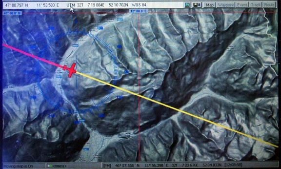
Maybe these pics do show how important it is to know the area in such conditions, not only from a map but really at visual sight. That is why we all here have to do an alpine introduction during our PPL, which is very useful. I remember that some years back there was even talk of banning VFR flights in the Alps for anyone without this introduction below 13000 ft after a series of accidents involving foreign crews but cooler heads prevailed thankfully. GPS and the presence of moving maps have had a very positive effect on accident stats recently due to the reduction in risk of flying into wrong valleys (one of the most common problems beforehand.)
Yes one can fly there like that but one needs discipline to not enter IMC, and if one does one needs to be damn sure of a lot of things, starting with the terrain ahead…
My impression from Swiss pilots is that they fly the canyons even under a total overcast. They have wx services which tell them the cloudbase in the main canyons, I seen to recall.
Incidentally, if anybody with Oziexplorer is interested, I have produced a complete set of topo maps for the Alps (and the Pyrenees) which look like this
It is 9.2GB total. I don’t see there is a copyright issue, as it was all generated from publicly accessible sources using Mobile Atlas Creator.
I think it is great if crossing the Alps above an overcast, IFR.
I can’t host it anywhere but could airmail a blueray DVD to somebody who can.
Peter, the Hotel you recommended in LDLO seems to have only one room left and it looks like it can’t be reached by eMail.
Alexis, I can recommend booking hotel Apoksiomen via Booking.com
Link: http://www.booking.com/hotel/hr/apoksiomen.en-gb.html
There is a free cancellation policy before 22 May. So if you plan your go/nogo decision Wednesday evening 21 May you can cancel the room without additional cost.
I just checked and there are still some rooms left.
Thanks, great!
Booked TWO rooms now (in case screaming kids and wife (not screaming :-)) want to come. If not then I might give up one room later, will keep you posted.
My impression from Swiss pilots is that they fly the canyons even under a total overcast.
The overcast is not the problem if it’s high enough. In this event I posted pictures off, I could see a long ways ahead of the route during the whole flight.
They have wx services which tell them the cloudbase in the main canyons, I seen to recall.
Well, I work for them
We have cameras in several positions which allow you preflight to check how it looks (on http://www.meteoschweiz.admin.ch/web/en/weather/current_weather/webcam_images.html) as well as the mentioned GAFOR routes which give a forecast of ceiling and visibility for the next 6 hour period.
I had flown the same route (to Samedan) a few days before in blue skies and quite a few times before. And generally, if there is an overcast which is higher than the mountain tops, usually the Alps are very uncritical to fly, as below the cloud there is less turbulence than if the sun was burning onto the hillsides. As I said, here the cloud base was around FL120 with a tad worse in the Engadin valley. Of course, there the ground elevation is around 6000 ft, so that leaves you between 4-6000 ft to fly in.
Basically, a weather situation like this is much less critical than one where you have half the mountains in blue skies and then all of a sudden a wall of cloud before you which forms a formidable barrier.
This situation here looked pretty much flyable, but only 10 km south of this it looked like this:
And shortly afterwards, tops reached FL180 (prediction was FL120…)
This wall basically reached all across the Alps on a line between the Valais and Austria, east of which was totally unflyable. We climbed up to FL170 where the airplane was at its limit (DA22000 ft that day) and followed parallel to the wall for over an hour in both directions, but could not see a safe crossing to the South. Below it, the ceiling was around 7000 ft AMSL. So this meant an in flight return and as it had been the only day promising a possible crossing followed by one week of solid XXX conditions over the Alps, it meant going back to ZRH and cancelling a 2 week trip ahead.
IFR over the Gotthard and then Italy would have meant 10 minutes in IMC in FL140-150 and sunny weather the rest of the trip.
Yes one can fly there like that but one needs discipline to not enter IMC
Yes. Particularly in the 2nd example, which incidently was BEFORE the other flight I posted pictures off, it was a situation where the mind played evil tricks on you. I could see the blue sky to the South, I knew darn well that the cloud tops were like that for not more than 10 miles with heavy CAVOK behind and that, at FL170, we were well over the terrain and event the MEA for the IFR airways going through there. The temptation was there to simply pull through and to continue our holiday, yet it was brutally clear to me that this was no go. So back it was, return to ZRH and throwing out of the window 3 months of preparations and buying airline tickets, which in retrospect, I should have done at least a week earlier seeing the model forecasts. It was a lesson I won’t forget in a hurry.
The trip to Rijeka 2 months later had totally different model predictions and worked well. Yet, I have never yet had a (planned) alpine crossing where I did not have to either climb over clouds or fly under them. Days without clouds are simply very few and far between.
Flight to the Matterhorn and back
This link leads to a trip I did in 2013 around the Matterhorn and all the way through the alps. There were clouds north of the alps which I managed to climb over easily but thereafter a wonderful flight in bright sunshine.
Alpine flying is one of the most beautiful things you can do, but it requires due caution and a clear comitment to throw away the plan and go home if there is any doubt at all.