Happy New Year to all! I’m at the point of deciding which satellite inflight weather solution install on my Cirrus Turbo Perspective. The choice is between the 1) fully integrated GSR56 garmin global connect (cost ~10k-15k) or 2) ADL120+Ipad or 3)Thuraya device+Ipad (possibly using the Aeroplus box, if already on the market), the last 2 solutions costing around 2-3k. Cost is certainly important, but more important to me is to have a realiable service, including radar and IR-satellite coverage of Southern Europe.
I believe only solution 3 (thuraya) has the radar coverage for Southern Europe because it can access internet data thanks to its higher speed. However, reading this thread, it seems to me also the least mature and reliable of all solutions (no plug and play, and a lot of DIY). Any recent development you are aware of?
Forgot to specify that it is a necessary requirement being able to see the GPS position of the plane superimposed to the radar and IR maps, and possibly have an automatic cross-load from the G1000 of the flight plan as well. The ADL120 seems able to cross-link with the G1000 (was it tested?) but I understand it lacks radar coverage for Southern Europe and it doesn’t have IR images at all.
Yeah…as neat as the ADL may seem, the radar coverage is still a joke. Not directly their fault, it’s their data provider (DWD) who doesn’t have any more coverage. What’s the radar coverage of the Garmin? IIRC, the Avidnye MLX is the same, i.e. no coverage for eastern Europe, southern Europe and most of Scandinavia.
The choice is between the 1) fully integrated GSR56 garmin global connect (cost ~10k-15k) or 2) ADL120+Ipad or 3)Thuraya device+Ipad (possibly using the Aeroplus box, if already on the market), the last 2 solutions costing around 2-3k.
There is also the Avidyne MLX770, which I believe a well known UK Cirrus shop is flogging to Cirrus owners. I don’t know what (if any) issues there are with it for a Cirrus.
Radar coverage has been a problem for ages for southern Europe. It does exist, but in pieces. For example there is Croatia radar and Italy radar. I believe that Avidyne did a deal with meteox.com for their data – or with whoever meteox.com get their data from (and pay for it via advertising). I say that because their coverage, when I last looked, was really similar. There was no data south of the Alps.
it is a necessary requirement being able to see the GPS position of the plane superimposed to the radar and IR maps
To do that using a DIY solution is nontrivial (not least because the data available to the great unwashed is a graphic image which would need re-projecting) but clearly possible.
This is a nice radar site. I expect they will shoot him when they find it 
BTW Valerio my plane is having its Annual right now, next to where your SR22 is parked We expect to be there for 2 more days.
With a Garmin MLX is not an option.Avidyne obtains its weather data from WSI. I think Garmin does the same .. however I seem to remember they do not disclose this?
I truly like the the ADL120 .. however I prefer the integrated solutions if possible.
I will also be expirimenting with the new Thuraya sleeve version 2 < the one which does support data>. as it is much faster.. but I also see it as an extra…
I am also looking forward to the box of Aeroplus.
I recently have been testing the Thuraya SATsleeve in the Cirrus. The SATsleeve costs about 600 euro to buy. Hang it somewhere in the aircraft next to a window (without the iPhone 5 connected. Connect the iPhone 5 by bluetooth to the SATsleeve to use the Thuraya app on the iPhone to configure the SATsleeve and call over the Thuraya network. Use any device e.g. a tablet (iPAD or anything else) to connect at the same time over WIFI to the same SATsleeve to get the radar images, use apps like whatsapp and even check your e-mail. Drawback is that you can only connect 1 device over WIFI and it will not allow more WIFI clients to connect to the SATsleeve at the same time.
Add to this all a Flightcell Pro adapter and you can receive calls and talk over the Thuraya network using your iPhone and all your iPhone contacts already in your address book on your iPhone. If you don’t have an iPhone, this solution is so effective that you should consider buying a dedicated iPhone 5c for it.
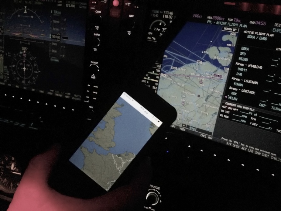
Here is a picture I took after having coffee in Shoreham and flying back home to Rotterdam recently just before Christmas last year.
On the back of the SATsleeve there is even an external Thuraya antenna connector, so this solution is prepared to work with an external antenna. I have had great success getting data in. Don’t have more pictures at the moment of the setup, but this is the solution (together with our own prototype) that I will be taking to Africa on my tour through Africa and Middle Eest later this month.
Aeroplus showed me the Thuraya “Satsleeve” recently. It is really impressive. You just need to buy a used Iphone 5 and stick it in there, and you have a self contained “satellite Iphone 5”.
But this obviously won’t give you georeferenced weather images. You can get all the data that exists, and it is especially good for ad hoc stuff like getting tafs and metars towards the end of a long trip, to check the options for landing and diversions.
I’m the creator of the ADL devices so beware my opinion might be biased ;-)
Unfortunately radar coverage is very expensive. So even if the data exists for some areas the number of pilots flying in these regions does not justify buying a license for this data. I recently spoke with someone who suggested a European radar composite similar to the one on the radar.cz site with a full license would probably cost around a million Euro per year. So far most users fly in the area GB -France – Switzerland – Austria – Denmark. Beyond we have wind, temp, METAR, TAF, SMS, tracking and I am working on more strike data as this is much more affordable.
Taking the data of some website is no real option. First it is probably illegal and second you do not get the raw data. This means for example that map features will be drawn over the data. This is no problem in the overview butin flight you will really zoom in. Then the black hole in the rain front ahead might in reality be a letter of a city name drawn over the radar echos. Been there.
Concerning the transmission there are two choices. Iridium and Thuraya. Avidyne, Garmin and my ADL devices all use Iridium. Iridium has got global coverage, is run really professional and works from all types of aircraft. We tested it on a Citation and it worked as it does in a C152. But the data rates are very low which means you can only run dedicated services no standard internet. Thuraya has got better data rates but from my experience the whole network and the devices are not rock solid. I currently get no calls at all about any Iridium outages but I would not feel comfortable selling any Thuraya solution. It might work very well in certain circumstances but no way I would sell such a solution and give 2 years warranty on it…
Valerio, are you aware of the special ADL120 fixture for the Cirrus airplanes?
How many DIY Thuraya solutions do we have on this forum? If this group is big enough I might modify my ADLConnect app and the backend to also work through this channel. I could not give any warranty for the whole setup as I do for the ADL110/120 but if the pilots take care of their internet connectivity on their own risk this would give them a very low data rate weather moving map solution.
Sebastian: you have a great solution. No doubt about it. No doubt as well that my response will be a little biased as well :-) Hope you don’t mind.
The Thuraya SATsleeve works great in my opinion and isn’t even my own product. It has a 64 kbits download speed, which is great. You can download any image and in 1-2 seconds you have it on your screen. At the same time you can stay connected by e.g. WhatsApp and that works without any delay. I was even able to validate flightplans and file them while connected to the GmPRS network and of course use our own AeroPlus Aviation Weather app to get all the latest weather data..
Above this, the data costs are a fraction of the Iridium costs and our AeroPlus Aviation Weather app does have (at least the beta I am now using myself) all the needed information specifically downscaled for SAT mode usage. And at a price of just about 600 euro, it is great value for money. I know from the reseller here that sells the SATsleeve that a lot of KLM pilots are buying them and that they use them while enroute. I can’t say too much about the quality of service as so far I have not used it that intensively yet. It seems that Thuraya is a rather strange company from Dubai, but so far they have responded to all my questions instantly and not given up. They had not activated the GmPRS/data on my card and this took them some time to figure out, but once this was working all worked fine. So far, the quality of data and voice is much better than that provided over the old Iridium network. When calling landlines (using the above mentioned flight call pro adapter) the receivers did not even recognize that I was on a SAT line. The quality of the line was very good. In fact, the US military is using the Thuraya network intensively these days and with Iridium staying behind with their 2400 baud data rate and older network of satellites, the faster connection offered by Thuraya feels very good and like something I do not want to let go of again.
Again, the Satsleeve is not even my product. The Weather app is of course. I will be testing it extensively during my trip through the Middle-East and Africa. I have been testing the signal strength as well in Norway and that was great even there.
Thanks Aeroplus for the pirep on Satsleeve: how does it compare with the XT phone+XT hotspot for use in a Cirrus? Does it need to be rebooted as well when crossing a region? Would you install a separate antenna and where in a Cirrus (perhaps in the space between the top-lining and the ceiling, accessible removing the door seal all the way down to the floor and then cabling from the arm-rest and via under the co-pilot seat)?
Sebastien, what’s the ADL120 Cirrus application you mentioned? Can you confirm it can cross-load the flight plan automatically from the G1000? Any chance to get also the satellite IR images (possibly with color-coding for tops, like in SAT24 website) at least for Northern Europe? If I were you, I would stick with the IRIDIUM for the moment: like me, most people don’t need to talk over the phone or send email really, they just need detailed and reliable inflight radar and cloud tops, along with METARs, in a NEAT and RELIABLE format.
Peter, how about “Radar inFocus” Ipad App? It seems to give free georeferenced Radar (even for Southern Europe) and free color-coded IR images: seems the perfect APP for Thuraya SatSleeve. To be candid, it seems to provide the same functions of the Aeroplus App but without subscriptions to pay: is it because in the market exist 2 type of radar data, one more precise (and therefoire at a cost) and another less precise (and therefore for free)?