would say it has to do with your mission profiles. While you fly IAPs to all possible limits and at night i fly light IFR mostly and RNAV GPS appchs whenever possible. I very seldom do appchs with a ceiling lower than 1000 ft.
I very seldom do appchs with a ceiling lower than 1000 ft.
In most cases that doesn’t need an IAP – it’s above the MSA 
I very seldom do appchs with a ceiling lower than 1000 ft.
That is called a let down, not an approach….
I have no problem with you calling that a “letdown”, and beeing 55 i have a problem developing enough hormones competing with you guys.
Occasionally i do an approach down to 300, 400 feet – but since i have no time to fly and practice IFR approaches all the time, i prefer to stay on the side that feels good to me.
I hope that doesn’t give anybody a sleepless night, that’s really not my intention.
People from the motherland of IMC have certain currency advantages over us South Europeans…
ROTFL
Peter wrote:
In most cases that doesn’t need an IAP – it’s above the MSA
Yeah I wish… here, MRVA is 5000ft, terrain mostly below 2000ft… and FOCA still thinks IFR in anything above D should not be allowed
For what it’s worth, I Australia you can only substitute DME by GPS/RNAV is the instrument approach charts specifically says so. It’ll say: “GNSS permitted in lieu of DME”.
Bear in mind that DME gives you slant range
Whereas GPS gives you lateral (horizontal) range
Different numbers.
For SID, STAR and approach procedures primary track guidance must be provided by the navaid nominated on the chart. Whether or not you use GNSS for enhanced situational awareness is beside the point.
Archie wrote:
Bear in mind that DME gives you slant range
Whereas GPS gives you lateral (horizontal) range
Different numbers.
Very different numbers.
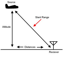
If distance is 4 NM and altitude 5000ft (0.82NM), then Mr Pytagoras claims that Altitude ^ 2 + Distance ^ 2 = Slant range ^ 2. That means the slant range is 4.083 NM. That is much less than the DME accuracy and test criteria.
I think the point Achim is making ironically (could have used a smiley) is that the slant range error is very small in typical situations.
A much bigger issue can be finding a GPS waypoint which corresponds to DME=0.