The only paper I carry on board is the one to clean the oil dipstick. And the EASA license
Hopefully one day Europe will reach the US and make it plastic in credit card format  Or just implant it in our ears
Define “proper” chart.
I have a vague recollection that there was a country in Europe which did require the carriage of paper charts, but it could be a rumour.
The whole concept of “official charts” has gradually disintegrated in Europe in recent years, with Jeppesen dropping theirs in 2013 and with most of southern Europe not producing any usable VFR charts.
Jeppesen has never been any more official than anything else.
I think what mostly happenend is that the term “chart” has blown apart. For a long time, there used to be be only one medium for “charts” which was paper, so everybody has gotten used to equate charts with paper.
Nowadays, this has changed and some naysayers still haven’t got used to it.
Are we more or less likely to find errors in the new electonic charts, for example Sky Demon, than the paper charts produced by our CAA for example? Electronic charts can be amended quite regularly and are I think more likely to be amended than expecting every pilot to make the changes to the printed charts. In any case I have seen so many pilots (VFR I must add) using “official” charts that are just a few years old!
Also, that “making changes to the printed charts” has always been a joke really.
How do you do that after all? With a pen?
Are we more or less likely to find errors in the new electonic charts, for example Sky Demon, than the paper charts produced by our CAA for example?
For the UK CAA, the point is moot because so many UK pilots use that program and they speak the same language as the developer, that errors are likely to get reported and fixed quickly.
For elsewhere in Europe, reporting of issues will be much more sparse, due to the culture/language issues.
But in much of Europe, there are no usable paper charts anyway, so the point is again moot. Pilots in say Italy either don’t fly very far (typical of most GA anywhere, really) or they use electronic tools.
How do you do that after all? With a pen?
Yes  You are supposed to watch some URL where changes are announced, and mark up your chart… fortunately UK airspace almost never changes and when it does it tends to “lift” up a bit.
Also, that “making changes to the printed charts” has always been a joke really.
How do you do that after all? With a pen?
Funnily enough, last year saw the release of 3(!!) German ICAO charts – one in March / April, the second edition in September and the third in November, never seen that happen before……
I have been using Sky Map for a few years and was quite pleased with it, very stable platform and an excellent support.
I have switched to SkyDemon since as nowadays Sky Map does not offer a lot of functionality over and above other tools and has a few downsides, especially their pricing structure for maps and plates. One has to spend in excess of EUR 500 p.a. solely to have current maps for Europe. IIRC, the maps are also only updated once a year in line with the paper versions.
I was just reading through the older pages and saw this statement – this isn’t correct, the maps are updated monthly, as and when changes come through – that’s how I became aware that there where three German ICAO charts for last year – 2014, 2014 second edition and 2014 third edition.
What makes Sky-Map my preferred choice can be seen by the screenshots from my Galaxy Note 3 – perfect size for mounting on the Yoke of a Piper.
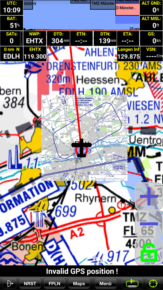
This shows my main screen, as you can see, the circuit for Hamm is shown (currently integrated AIPs are available for France, Germany, Austria and Switzerland and are updated monthly – if you subscribe for the year, you get the monthly updates so your AIP info is always up to date – when was the last time you updated your Pooleys ;-)
The boxes at the top show the salient info – for example, airspeed, height, position (great if ATC asks to state your location – look at the box and just read out) and FIS frequency. Also at the very top you’ll see the airspace cross section in front of you and the ground, makes sure you don’t hit those pesky rocks in the clouds….

If you wanted the full information about the airfield (as indicated, just F, AT, D, CH at the moment) you can get all the info you need….
Another shot, if this was an airfield with taxiways, stuff like that, you’d have that also shown, geo-referenced.
So, yes, you CAN pay a lot for the charts but as these can include the AIPs (I think I paid €557 including all those AIPs) it’s a case of getting what you pay for and I wouldn’t fly without it. On top of that, if I had an AHRS it’s already compatible, if you have a subscription to DWD (I do), you can overlay the weather and (this time registered with DFS) NOTAMs. Makes flying very pleasurable and it also collaborates with Flight Planner – a PC based software.
With Flight Planner you can plan your route, have trip kits prepared which includes all the paperwork you need – maps with AIP printouts including alternates, Flight Plan for DFS and your own VFR Plan including times, weight and balance. Once you’ve done that, just export it to Sky-Map (each software has an individual number). By putting multiple numbers in, multiple Sky-Map programs can receive the same planning, great if your club is flying together.
A final point – I fly Night VFR and in Germany we need to file flight plans according to IFR way points. Sky Map also includes the German Lower Level Airspace so I can plan my route that way with ease and fly the route using Sky-Map….
Sorry if this sounds like advertising, I don’t work for them but do rate the software very highly…..
Just to be precise: DFS does not publish any updated paper charts in the course of the year.
They probably still keep track of the various changes in their “ICAO chart database”, so Sky-Map probably managed to incorporate the changes, even though it is what we call a “raster chart” product.