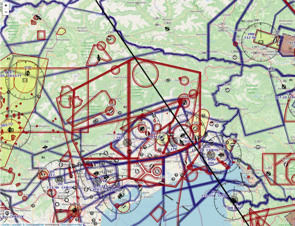
I am planning to do this VFR (black line is intended flight path) in north-east of Italy:
After having puzzled a bit over it, maybe someone can give me some input on this. The line goes more or less from Innsbruck over to Croatia. There are several (military) restricted airspaces and approach zones which are to be crossed. There are no airways in that region there, not even so many waypoints, which I could stick to, so I’m puzzling about whether crossing of that area will be possible as easy as I’m hoping.
Are there any tips around e.g. which altitude (or route) could work best for this in order to be able to cross that zone? I’d be flying in around FL100-120. Or would I get coordinated by Radar? Can anybody share an experience if I’m gonna expect trouble?
According to my personal experience, it is quite easily possible to cross airspace D with Treviso Radar, however, you can’t cross the restricted region “Zita”, in case it’s active. Even though the southern zones C and D have a lower limit of FL130, the northern zones over the southern Dolomites/Alps have a lower limit of FL50 or 2.000 AGL. This is not gonna be helpful for a relaxed crossing over the mountains. I would go for a routing which circumnavigates the zones A and B of LI-R49.
So just to summarize what I found out and what I was planning to do: Region Zita LI-R49 (all that ugly red in the map above) is only active if stated in a NOTAM. Actually there’s no NOTAM around regarding LI-R49, so it’s not active (will double check that on the day of flight, for sure). Same is true for those red “round” zones on the map which are military firing zones – only active upon NOTAM. (Not sure if I’d cross a military firing zone anyhow, but that’s another game). But even when any of the red is active, any crossing is coordinated by Aviano Approach on 120.125. And according to the MIL AIP rerouting or specific flight level may be assigned – which is no problem. But even the approach zone of Aviano (all that ugly blue in the map above) is only active if there’s military traffic, if not all is airspace G. So case may be that there’s just nothing active. But if there is no NOTAM about LI-R49, I’ll proceed straight through and ask for coordination. (By the way, from Friday 11a.m. until Sunday night sky is all open)
I experienced once that even without NOTAM, FIS (Padova Information) warned me about a spontanious activation of LI-R49, so I had to avoid it. This happened back in September 2019. According to FIS, but that has not always to be true, coordination for a clearance was not possible. I decided to fly through the valleys towards Ennemonzo.
Region Zita LI-R49 (all that ugly red in the map above) is only active if stated in a NOTAM
Where did you get that from?
Looking at where that black line starts and ends, a dog leg towards the east avoiding the red stuff adds a pretty minimal distance but will allow you to fly relaxed into the Slovenian and Croatian airspace. I’ve chosen to do this every time I’ve come close to this airspace mess.
UdoR wrote:
Region Zita LI-R49 (all that ugly red in the map above) is only active if stated in a NOTAM.
AIP-Italy says H24…?
Mooney_Driver wrote:
I’ve chosen to do this every time I’ve come close to this airspace mess.
Yah in the end I’ll do that, however diverting right from start, so in total it’s only ~3nm more. By doing this I have a chance to maybe climb right from start to cruise altitude following airways. So I don’t need to set up nuffin more in cruise and let the AP do the job. Why not. Then I’ll take the Felbertauern-route passing between Großglockner and Großvenediger as I did so many times already 
Airborne_Again wrote:
AIP-Italy says H24…?
Yes I mixed it up, seems to be H24, I was looking at the wrong Area. So one reason more to just stay away..
It’s not always defacto active, so you might be able to fly through if FIS or Radar reports an inactivated status, but in general, it is indeed active H24 and should be avoided by default planning. Back in 2020, I was allowed to fly through several times, as Treviso reported clearly “no military activity, you may cross”.
What day of the week do you plan to fly through the area?
I flew from Switzerland to Portoroz and back via Zernez – Bolzen – Trento on subsequent weekends in June. I always have a plan after Trento via VIC to allow low level across the Po plain at 1’000ft. But I don’t like flogging around that low in the poor viz. Around Bolzen I asked Padova Info for as direct as possible after DIKEM (near Trento). I was at FL120 at the time. They said standby and came back a moment later and asked would direct DIKEM – VICKY be ok (VICKY is the VFR entry point for Portoroz CTR), and what level I wanted? I said that would be great and I’d like to stay high as long as possible. I was cleared DIKEM DCT VICKY at FL120. I had to ask for descent about 30 miles from VICKY to get down to the required 4’000ft ASL in time. On the return, I was handed over from Portoroz to Ronchi at VICKY and requested climb direct DIKEM up to FL120. They approved direct as requested up to 5’000ft and before reaching cleared me on up to FL120.
On a similar previous trip, same route but during the week, my routing was via VIC and after Bolzen I asked Padova Info if I could stay high (this time at FL100). They said I would need to be down to 1’000ft by VIC due to traffic, but suggested that routing further east I could stay higher. In the end they sent me in the direction of AVI but I needed to get down to 5’000ft after the mountains. I was able to stay at 5’000ft but after AVI they routed me via Lignano and then along the coast to VICKY. All via clearances through CAS. Very helpful and agreeable. Both Aviano and Ronchi were active. On the return basically the reverse, keeping 1’500 along the coast to Lignano and then direct with a climb direction DIKEM.
Generally, if you know what you want and enunciate your request/wishes clearly and politely then chances are good. If you can’t get exactly what you want, indicate your general wishes and ask what would work for them. Good radio work and maintaining cleared route and altitude precisely reinforce that you know what you’re doing and are trustworthy. Use IFR waypoints when making routing requests. ATC knows them all of course and it may help to keep you up high. If you are forced to descend down low you will likely end up with VFR waypoint routings so be prepared for that.
BTW, R-49A base is 2000’ AGL which I always find a humorous thought crossing such mountainous terrain in anything less than an F-18….. not sure what 2000’ AGL means when crossing high (8’000ft) ridges with valleys between. Note that flying from Bolzen or from the north generally south to DIKEM or ROKIB will get you south of R-49A.