
Hi all! Something to keep us busy while flying isn’t easy.
Let’s say someone wants to fly from EHAM to LOWK, however, instead of the most direct route, it is desired to find the route allowing the lowest possible flying altitude. Let’s say terrain elevation plus 1000ft.
Do you know any program that can do this?Theoretically any flight planner should be able to do it, as long as it observes the max altitude for the airplane in question, at least IFR. VFR it is a different story, as there are no real minimum enroute altitudes available. Also in IFR, the abolishment of airways may throw a problem here.
I recall running route tests for airplanes with service ceilings around 12000 ft and the old Jeppesen flightstar IIRC would route you all the way around the alps. Quite possibly Autorouter will do that as well in IFR.
VFR I am not really aware of any program which has autorouter functions worth much.
I do that in SkyDemon using terrain colour with a reference altitude number, plot the route with few point & check it but you still need to load something legit in your GNSS  , it’s useful for for finding routes with lowest MSA then try them in VMC, I would not go into somewhere unfamiliar based on that in IMC
The problem is that the lowest altitude route complexity may change dramatically when you go at 950ft instead of 1000ft, especially in your part of the world, something to be aware of, also limit heading changes to a small number otherwise you are flying a fractal curve that needs infinite fuel…
I had few of those routes between France and UK (and flew them for fun in VMC down to “legal 500ft agl” and I can navigate it visually), it’s +60% overhead vs direct routes, not smuggling anything under the radar just mitigeant if encountering severe airframe icing, last time it was a hastily precautionary landing on whatever was bellow me after I touched MSA of direct route and decided to call it off
It will not be useful in places where IFR is restricted to airways and min vectoring or if VFR is done above 3000ft amsl
It’s the same thing as plot route, get MSA, plot another route get MSA, rince and repeat
Snoopy wrote:
Do you know any program that can do this?
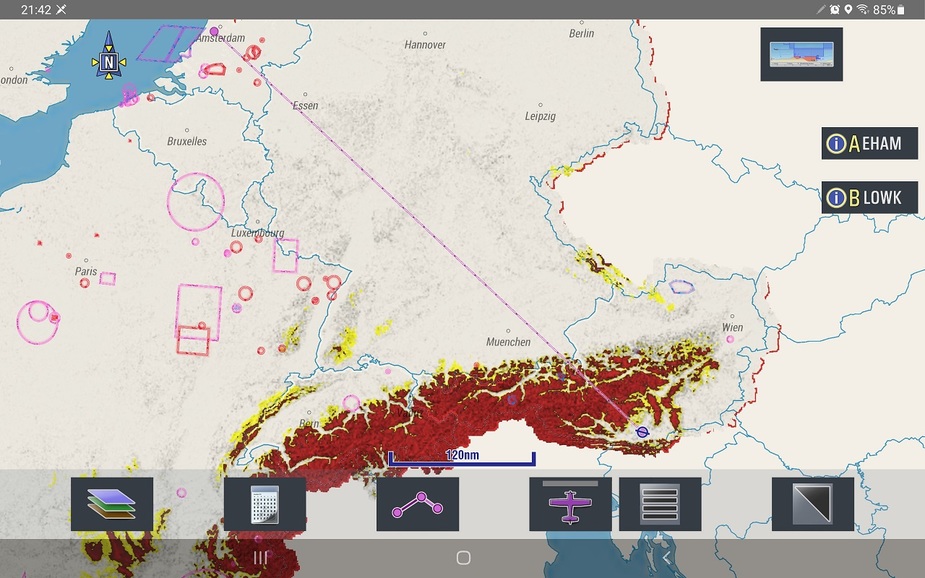
EasyVFR can certainly do this for you. For planning, it’s called “Valley Terrain” and you set your planned altitude. Terrain is then coloured red if you have less than 500ft clearance (increasingly dark red as you’ve less clearance) and yellow if you’d 1000-500ft ground clearance, and no shading if you’ve more than 1000ft.
So here is what it looks like if you’re planning on a flight at 4000ft. Possible but with a significant detour.
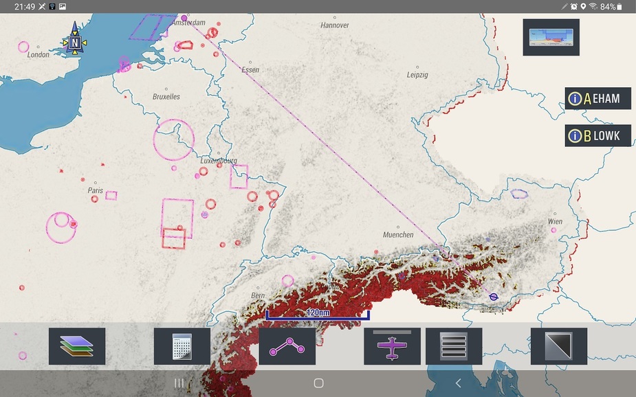
Here is what it looks like with a flight planned at 6000ft. Possible with less of a detour, and possibly without a detour if you’re willing to climb for a short period.
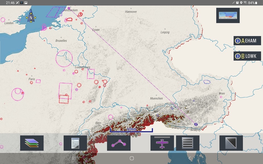
Here’s what it looks like from 8000ft. No problem at all.
There is a free 30 day trial if you want to try it out for yourself. I’d be happy to give you some guidance on how to set it up and where to find this feature.
Colm
Thank you.
Taking @dublinpilot ‘s examples (and thanks for the trouble of screenshots btw), the lowest route might be a detour around the alps completely.
What I want to achieve is to find not the lowest safe altitude on a direct route but the (as detoured as necessary) route enabling the lowest altitude.
Yes, I could “rubber band”* the route line back and forth until I find lower terrain, but there must be a way to use the freely available elevation data to automate this.
*I’ve been doing it in Foreflight using the profile view and it’s not convenient.
The idea is essentially to find a route over the lowest terrain, a bit like how water would flow and then add 1000 feet.
MSA quadrants are useless because they are based on the highest elevation and thus “override” any lower paths.
I’m sure one of you geniuses on here can figure it out. I can’t :)
I find climb gradient is equally important to elevation when planning, but that depends on where you take off.
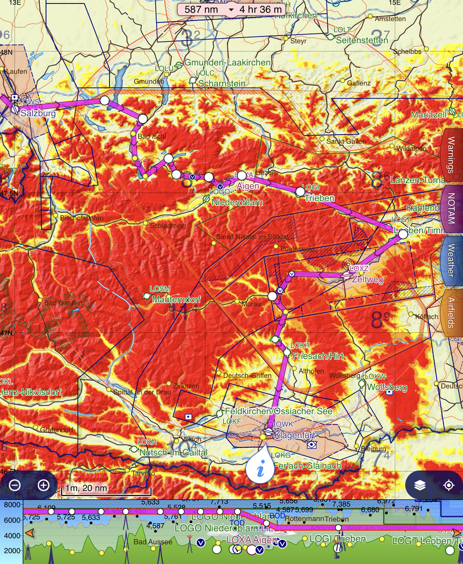
Here you go, 4000ft with temporary 5000ft climb, not sure if doable in GA aircraft but Swiss Air Force F5s can do this At 3800ft you have to go full detour
Snoopy wrote:
The idea is essentially to find a route over the lowest terrain, a bit like how water would flow and then add 1000 feet.
The solution is called a large paper map Seriously, this is precisely the kind of thing that’s easy to do on a (good) paper map, but almost impossible with an app. You may not get the optimal solution with paper, but that’s much better than no solution at all. There are other maps with good info of the terrain that can be used, but you still have to study it first and “transfer” the route to SD or similar.
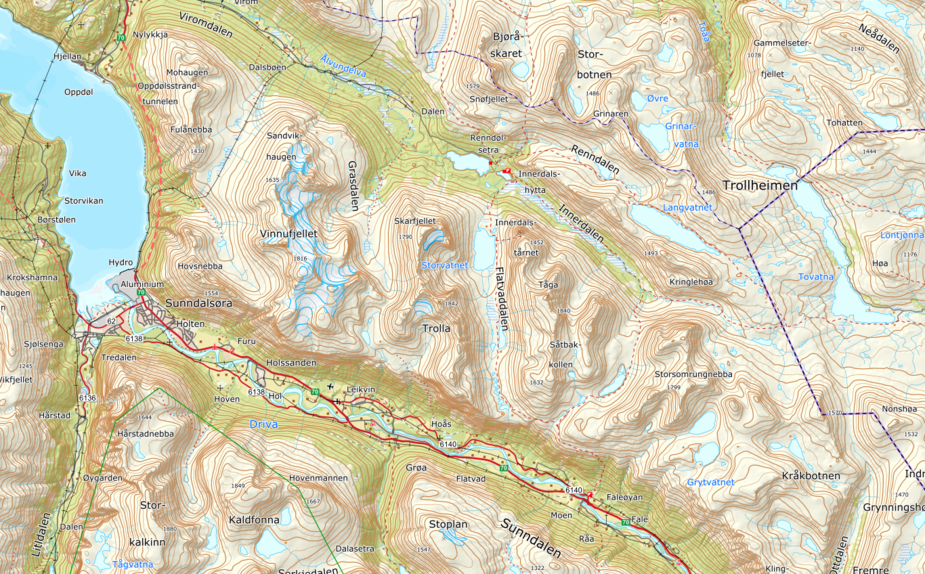
For instance. This area is darn cool to fly in and out and up valleys and through passes. This is what you see in SD:
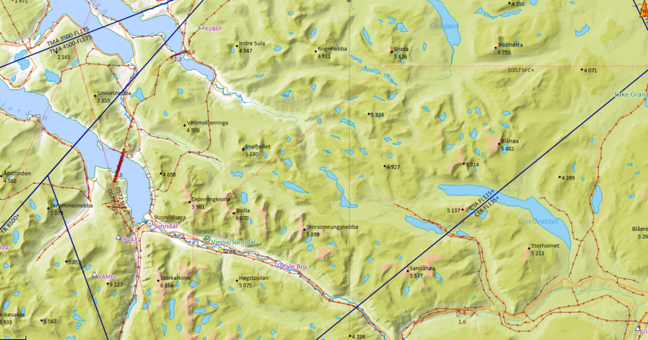
This is what you need to see to be able to plan a cool route:
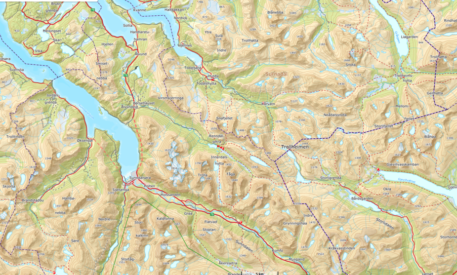
It’s a good idea to study the terrain thoroughly in any case though before flying down into it.
Edit: That didn’t look all that good on that picture, the resolution disappeared. With the other map you can also zoom in to each house if you want. Here is a slightly zoomed picture:
Ibra wrote:
Here you go, 4000ft with temporary 5000ft climb, not sure if doable in GA aircraft but Swiss Air Force F5s can do this At 3800ft you have to go full detour
I did the same in foreflight, thanks for your effort ;)
LeSving wrote:
The solution is called a large paper map
I have paper aeronautical maps for austria (the military makes a nice one, you can find another good and official one here) but even on a large hardcopy map it’s difficult not to miss some “lower terrain option”. Let alone having accurate paper maps (including the ability to interpret them correctly for all of europe, @Peter explained the french problem with ft and m before).
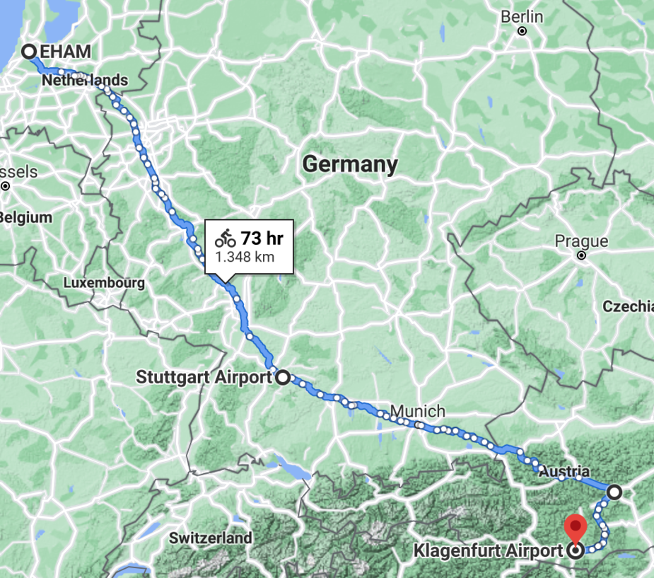
FWIW I used google maps and the “cycling” route feature to find a path between EHAM and LOWK with maximum elevation of 3170 ft, not bad (high) I think.
Ideally, a software would work in a similar way, but take into account minimum turn radius at cruising speeds among other parameters.
Think of it like a custom GAFORoute that can be adjusted as necessary.
It looks like easy VFR is a good option. @dublinpilot could you please post a pic showing 3200ft, I’d be interested in the areas that have no shading. Thanks.
Nice one on cyclist routes, it may work for Category 0A flying: Cubs & Maules
The biggest risk of going in lower altitudes is computational complexity & over navigating, a software can enter a dead end and roll back, a pilot is pretty much dead if he enters a valley at the wrong height, the deadly mistake usually starts 50nm ago where he should gone right instead of left or climbed…
I think flying at constant planned amsl altitude is the right thing to do, rather than 1000ft agl, any hope of out climbing terrain will fall short as one gets 2% climb gradient, which is 2D for practical flying near 3D terrain, unless you have an afterburner, I can’t see how one can maintain 1000ft agl even with an AP on Radar Alt mode 


