This slot system is IMO a complete waste of time
like any plan economy. Full agreement.
It is remarkable how often visibility is only 4500m, even while the rest of switzerland is "VOK" - Honi soit qui mal y pense.
I take that as a personal insult Tom. Our people are VERY well aware of the problematic and won't influence their METAR reports for ANY reason whatsoever.
You are certainly right that ZRH's management is trying to hinder and generally dismiss GA but it is a totally different story what the people at the front think and how they act. And it does not help if we get faced with groundless accusations, on the opposite, it will turn even those people who so far are for GA against it.
Would someone please describe in plain steps how to access the information on cloud heights etc. using GRAMET. Thanks
Go here.
In the top box enter say EGKA_LFBZ.
In the next two boxes enter the start and end times of the proposed flight, noting that you have to get these right as per the times shows e.g. "START: 14/08/2013 19 UTC". Anyway, if you make a mistake it will be obvious from the time axis on the resulting plot. For a flight EGKA-LFBZ tomorrow morning you will need to put in something like 12 and 16 into these two boxes (for a 4hr flight).
Finally enter the desired flight level. This doesn't do anything except draw a yellow line on the plot, and add some data underneath which applies to that level.
The site has limitations which are coming to light as more of us use it. It doesn't appear to forecast low level stratus cloud, for example.
Thanks Peter, have it cracked now.
A user had brought up large discrepancies between the “original” OGIMET GRAMET and autorouter’s own prototype implementation. At the time I could not explain the discrepancy. Now we’ve had another case where for a flight from Berlin to Friedrichshafen, OGIMET gave this:
It looks like a nice and jolly VFR flight. The pilot was very surprised that autorouter plotted this for the same route at the same time:
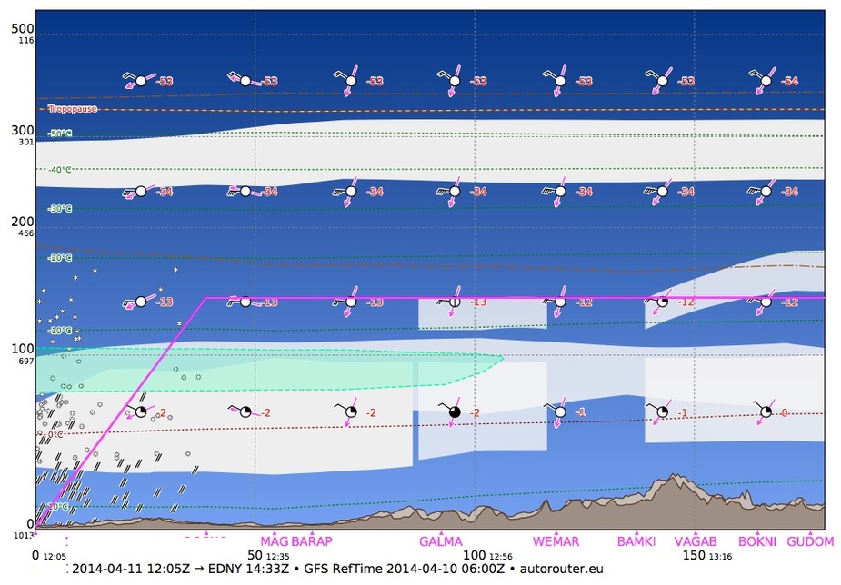
and the 2nd half of the route:
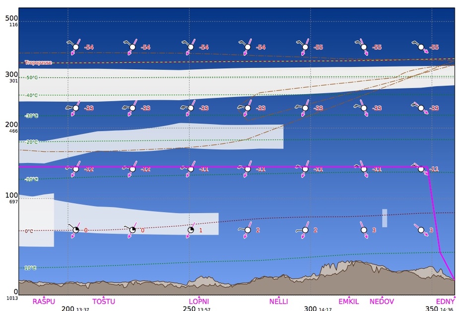
Quite a difference! And now take a look at this picture of the airplane’s wing, taken by the pilot.

This limited his climb ability to FL110 and costed 15kt of airspeed. I am not saying our GRAMET implementation is error free (it is still a prototype as I mentioned) but I believe there is something wrong with OGIMET. It uses exactly the same weather data as we do (in our example its data was 6h older) and the plotted image should be very similar. This example shows that our algorithms for predicting ice (the green area) worked very well in this case.
As visually appealing as these GRAMET images may be, please do not use them as your only source of weather information!
I have often commented that OGIMET tends to completely forget low level cloud, and anything else is rather random.
Graphically it is very impressive – even more impressive than the old Meteoblue site (java based and thus working only sometimes) – but I would not rely on it. It tells me no more than a 10 second look at the MSLP (surface analysis) chart.
I had attributed those deficiencies to the GFS data but it seems to be an OGIMET implementation issue. I believe the GRAMET presentation is the most pilot friendly weather overview I’ve ever come across (which is why I wanted to have it on the site) but it needs to be trustworthy. There is a lot more information in GRAMET than a MSLP.
I got the same when I was flying to EDNY and autorouter’s interpretation was the correct one.
As part of the autorouter, we’ve implemented our own GRAMET, based on Ogimet’s original idea. The reason we did this is because first of all, Ogimet only knows major airports and we wanted to plot an exact flight plan and also we considered Ogimet to be overly optimistic about clouds and icing. Also we wanted to use vector graphics instead of bitmaps for better readability. We’re still in the early stages which is why I didn’t want to make a big fuzz about it. However, lately we have received several reports about Ogimet being totally off whereas our GRAMET was very close. I have been observing Ogimet and indeed, there is a major problem with it. I hope it will be resolved.
So to cut to the chase, we have created a standalone GRAMET interface that does not depend on an IFR route generated by the autorouter. You can enter any list of airports, navaids and waypoints and choose an altitude as well as departure time and flight duration.
This is accessible via http://www.autorouter.eu/gramet or http://router.euroga.org/gramet when using your EuroGA login.
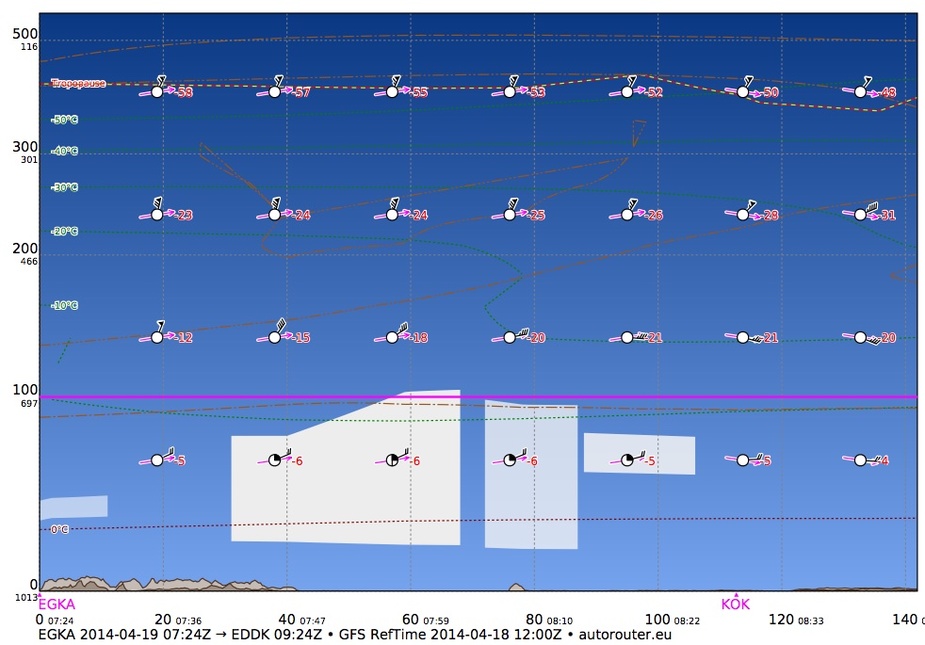
To help you understand the image, we have created a small GRAMET interpretation guide explaining the various bits of information and symbols used.
I am mostly interested in feedback. How readable is it? Which kind of information would you like to see? How close to reality is especially when compared to other sources?
Great Achim, thank you.
Will start using it and stand by for feedback.