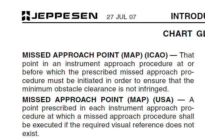
Bear with me because I’m not sure how to ask this question but have a look at the Missed Approach Point on this chart. There is the block M and the pull up symbol. The block M is clearly at the threshold and the pull up point is presumably at the DA (according to the Jepp symbology).
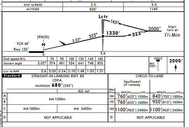
If I understand correctly the M is for use with the timing vs GS which because there is no distance information (DME) you can’t know where the runway if you don’t break out. Using CDFA you would reach the DA well before this point if you measured your GS accurately (using GPS presumably) but could fly well past the threshold before going around if underestimating groundspeed. Is the possibility of this error taken into account (starting the go around after the MAP could reduce obstacle clearance margins)? Descent to the DA at 100 kt gs would be accomplished in 1:13.
Also does Part-NCO even allow “dive-and-drive?” or descent to MDA and continuing to the MAPt?
Without checking the regs now I can say that there is no more „stepdowning“ or dive and drive. The DA/MDA is based on CDFA (constant descent final approach) with a visual descent point.
Jepp adds some confusion by listing DA/MDA. An MDA you cannot undershoot, a DA has some margin.
I presume the missed approach point is still referenced for mathematical/historical/procedure design reasons.
Without vertical guidance (such as ILS), a poorly executed CDFA could otherwise lead to problems like you mention.
I this example from an RNP approach? The distance on those is based on gps and rwy threshold, makes it easier to crosscheck the descent.
All valid questions, in practice it doesn’t really make a difference, and serves more to overcomplicate things. What does apparently make a difference is less people ending up killed after poking around close to the ground in search of a runway.
Cttime wrote:
If I understand correctly the M is for use with the timing vs GS which because there is no distance information (DME) you can’t know where the runway if you don’t break out.
I would say this is over interpreting the chart.
The point M simply denotes the latest lateral position where you have to initiate a missed approach if the landing is not ensured (independent of your altitude). In many cases this is at the threshold but in some cases it is before that – mainly for missed approach climb gradient reasons.
In approaches where you could do “dive and drive” (i.e. you can safely fly the missed if you arrive at the threshold at the MDA) you have a “V” on the chart at the position where you should stop the descend and then a dashed horizontal line to the “M”.
Snoopy wrote:
Jepp adds some confusion by listing DA/MDA.
Could you explain what you think is confusing here? How should they indicate that DA and MDA is the same w/o “confusion” if not that way? (and yes, you need both on a CDFA approach as there are operators that use ops spec C073 …)
This Jepp doc explains it. I need to read it again after coffee.
It’s not a RNP approach and there is no DME at the airport.
Cttime wrote:
If I understand correctly the M is for use with the timing vs GS which because there is no distance information (DME) you can’t know where the runway if you don’t break out.
Jeppesen charts always use the M to mark the MAPt. It is not specific to timed approaches.
Using CDFA you would reach the DA well before this point if you measured your GS accurately (using GPS presumably) but could fly well past the threshold before going around if underestimating groundspeed. Is the possibility of this error taken into account (starting the go around after the MAP could reduce obstacle clearance margins)? Descent to the DA at 100 kt gs would be accomplished in 1:13.
Yes. In the case of your example approach, an MAPt error of ± 2 NM is assumed in the procedure design. To overshoot that, your actual groundspeed must be more than 50% higher than your estimated groundspeed. The error margin depends on the nominal distance from the FAF to the MAPt, but can never be less than 39%. (PANS-OPS volume ii, part I, section 6.1.5.3)
Also does Part-NCO even allow “dive-and-drive?” or descent to MDA and continuing to the MAPt?
Yes, it does, but with higher visibility requirements. (GM4 to NCO.OP.110)
Snoopy wrote:
there is no more „stepdowning“ or dive and drive
Can you confirm that this is now absolutely true?
Although CDFA is taught and encouraged, is it obligatory?
There are some of us – Rod Machados included – who still maintain that in certain circumstances ‘Dive & Drive’ is safer and more likely to produce a landing.
Peter_G wrote:
There are some of us – Rod Machados included – who still maintain that in certain circumstances ‘Dive & Drive’ is safer and more likely to produce a landing
I don’t think it’s mandatory, on skills the only advantage of CDFA is standard between precision & non-precision, so no new or extra skill to learn & maintain 
The merits of CDFA vs ‘Dive & Drive’ depends on runway length & wind required to burn D&D height vs extra visibility required in CDFA to see the runway, these should not be mixed with pilot personal opinions, obviously, ceiling requirement is roughly the same for both CDFA and D&D (ignoring various theoritical add-ons: 50ft PEC, 50ft inertia, 100ft personal minima)
PS: Rod Machados fly 4km FAA-land runways of course D&D works better for him to increase the dispatch rates 
I am sure he would have flown CDFA to Scillies, Fairoaks, Blackbushes !
Airborne_Again wrote:
Jeppesen charts always use the M to mark the MAPt. It is not specific to timed approaches.
Agreed. But in this case, that plate seems to be of a timed NDB approach. The hint is “Start turn at 1.5 min”.
It seems the timing is required to locate the MAPt.
I believe there is some confusion regarding the definition of MAP on CDFA non-precision approaches. On the one hand, you go around once you hit the DA, hence that is effecitively the “missed approach point”, since that’s where you commence the missed approach. On the other hand, you’re supposed to stay on the final approach track until hitting the “M” on the chart, then you follow the lateral missed approach path. It seems like the former is what Jeppesen refers to as “point of arrival at decision height” and the latter is the “missed approach point”.
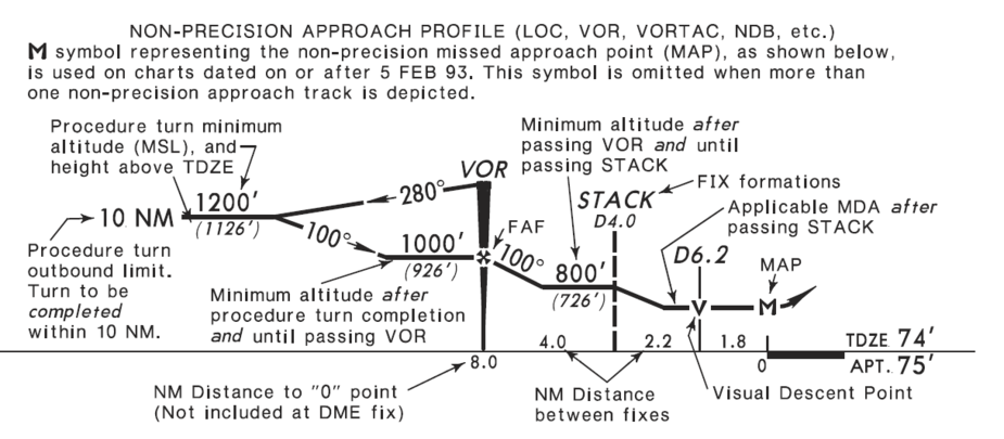
The “V” for “Visual Descent Point”, not always specified, is the point on a “dive and drive” approach from which a “comfortable” descent to the runway can be made when flying level at the MDA, I assume at a 3º slope.
Airborne_Again wrote:
Yes, it does, but with higher visibility requirements. (GM4 to NCO.OP.110)
Do those higher minima need to be specified on the plate, otherwise it must be a CDFA?
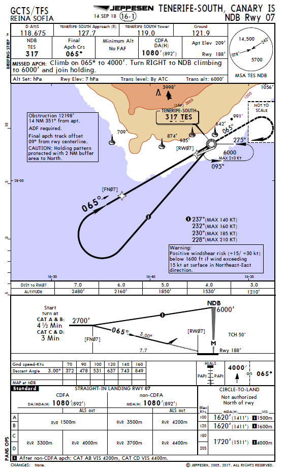
This plate for GCTS NDB Rwy 07 makes a distinction between CDFA and non-CDFA (i.e., dive and drive):
I am sure he would have flown CDFA to Scillies
From my personal experience in flying this approach I believe, from his writings, that Rod Machados would emphatically have flown it ‘Dive & Drive’.
With all approaches to The Scilly’s being over the water no step-downs are required,
Apart from Rod Machados concerns that ‘home-baked CDFA’s are far from accurate’, he emphasises that under ‘Dive & Drive’ you can settle down to MDA earlier with the ability and more time/chance to see the PAPI’s further out (than under CDFA): A major factor and important aid in low visibility at St Mary’s.