
Don’t know about EGNOS, but the three Geo satellites used for the WAAS corrections are also providing a PA position source as if they are also a GPS satellite providing ranging. They did not always do so and are not required to do so. In most of the CONUS, this provides 3 additional GPS satellites to determine 3D positions.
Well, I’ve had this GPS running all day, with a counter of all the SBAS satellites it picked up, and it is reading zero  And #123 is definitely in line of sight. I wonder if the antenna is relevant, but the frequency is 1.57GHz like all the GPS ones, and this antenna came with the Aera 660.

A certified WAAS antenna has a higher gain, but otherwise should be able to receive either the SBAS satellites. The L1 frequency is used for both SBAS signals and GPS signals. The EGNOS satellites will provide the SBAS signals, but whether or not they provide the GPS signals is a separate matter.
Here is some basic information from RTCA DO 229D:
GPS Signal Characteristics
The GPS ranging signal is modulated with data at 50 symbols/second that defines the
satellite’s position, system time, clock correction parameters, as well as the health and
accuracy of the transmitted data and ranging signal. The user computes a pseudorange to
the satellite by timing the arrival of the GPS signal. The user equipment uses the
pseudoranges from the satellites to compute the receiver’s internal clock offset and a
three-dimensional position fix. A pseudo-random noise (PRN) code, known as the
Coarse Acquisition (C/A) code, is generated at a rate of 1.023 MHz and modulated onto
the GPS L1 frequency (1575.42 MHz). All GPS satellites transmit at the same L-band
frequency. The carrier is modulated with a specific C/A code for each GPS satellite.
The GPS coordinate system provided by the signal is the Cartesian earth-centered earthfixed
(ECEF) coordinates as specified in the World Geodetic System 1984 (WGS-84).
The GPS position is determined in the WGS-84 coordinate system
WAAS Signal Characteristics
The WAAS signal is transmitted from geostationary satellites on the GPS L1 frequency
(1575.42 MHz). The 500 symbols/second WAAS data stream is added modulo-2 to a
1023-bit PRN code, which will then be biphase shift-keyed (BPSK) modulated onto the
L1 carrier frequency at a rate of 1.023 Mega-chips/second (Mcps). Detailed WAAS
signal characteristics, as well as formats and data contents, are provided in Appendix A.
The WAAS network time (WNT) is maintained such that the offset from GPS is less than
50 nanoseconds. The WAAS network time offset from UTC after correction is less than
20 nanoseconds.
One can see on the satellite page of a GNS430W/530W or GTN system if the SBAS satellite is providing a GPS signal. If one is not being provided, the signal bars will be empty verses the GPS signal bars will be filled with either green or blue. Green indicates it is being used for determining position and blue indicates it is not. Also a D is used to indicate if the GPS satellite data is digitally corrected or not.
Since the GPS system is a US system operated by the military, I wonder if the GPS signal is permitted? Someone in Europe who has a WAAS GNS/GTN GPS might be able to answer the question by posting a picture with a screenshot of the satellite page.
The US GPS system is used worldwide for navigation including approaches, officially, but uses locally generated SBAS signals, which in Europe are from the EGNOS geostationary satellites (image above).
The GTN and IFD etc boxes are coded to process both WAAS and EGNOS, and I guess the other SBAS signals elsewhere.
Mysteriously, the GPS receiver module I am using, NEO-M9N, pic above, which is supposed to support everything, doesn’t show any SBAS reception.
Peter wrote:
The US GPS system is used worldwide for navigation including approaches, officially, but uses locally generated SBAS signals, which in Europe are from the EGNOS geostationary satellites (image above).
In the US WAAS system, the geostationary WAAS SBAS corrections are the same as other SBAS systems. In addition to the WAAS signals, these satellites are also provide a stationary GPS like signal that can be used as if they are additional GPS satellites.
Peter wrote:
Mysteriously, the GPS receiver module I am using, NEO-M9N, pic above, which is supposed to support everything, doesn’t show any SBAS reception.
Are you expecting GPS receiver module to see a GPS signal from the EGNOS satellite? The EGNOS satellites may only be providing an SBAS signal. This should be obvious if someone can post a picture of a WAAS GPS receiver showing the satellite page while receiving EGNOS SBAS corrections.
Are you expecting GPS receiver module to see a GPS signal from the EGNOS satellite?
Yes.
The EGNOS satellites may only be providing an SBAS signal.
I am sure that is true. I’ve never heard of EGNOS satellites participating in the position fixing constellation.
This should be obvious if someone can post a picture of a WAAS GPS receiver showing the satellite page while receiving EGNOS SBAS corrections.
I posted some of the AERA660 here but would need someone else to do it with a panel mounted box. In the aforementioned link you can see a satellite #33 which appears to correspond to PRN #120 as per here which is the 1st EGNOS satellite shown here. EGNOS #38 shown on the Aera660 I cannot find except here but can’t find its PRN (probably it is 123). But hey we have done this before
It is also likely that the GPS module is not processing anything with a PRN above 32.
The manufacturer told me they support PRN IDs 120 to 158. I can’t right now find a clear cross-reference table to the vehicle IDs.
This is from the interfacing manual:
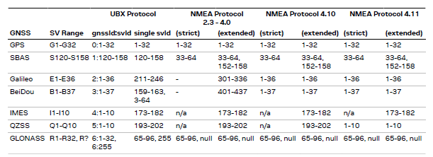
I am interrogating the module via UBX because it delivers the data of interest in seemingly fewer messages.
I found a wiki saying that 120-158 have been allocated to SBAS.
Those above 32 are SBAS. Just add 87 to get PRN. On my AERA 796, satellites 44, 46, and 51 show as the WAAS satellites. They are respectively PRN 131, 133, and 138.

