
You know your ground track and ground speed, you assume that the wind field and TAS are constant.
Multiple data pairs at a range of tracks allow you to solve simultaneous equations for TAS, and for the wind vector. From those, you then know for each data pair what the heading was. From that, it's easy to work out the compass errors.
G
The "2 simultaneous equations with 2 unknowns" etc approach is the rigorous way to do it, but is needed only if all parameters contribute at a similar order.
In this case, in deriving heading from GPS track, wind is only a second order effect (unless it's a Tiger Moth on a bad day  ) so it's easier.
In fact I am suprised this is not done more widely because compass swinging on the ground is a hassle, on some types is pretty inaccurate (due to non-representative magnetic configuration of the airframe etc) and any ten-bob camping shop GPS will give you the GPS track within 1 degree. Maybe it's because compass swinging is supposed to be done by an engineer and most of the UK ones never fly in the aircraft they work on. The one I work with is an ATP, CFII, A&P/IA.
Without going through the method, and applying an error analysis to it, I can't comment - and I suspect that you don't really know either. But that's do-able as well.
In general however, the more datapoints, the best potential to remove error in a method like this.
G
It's actually pretty easy to check the end result, by picking any light-wind day and adjusting the heading until the GS is minimised or maximised, and then track=heading, within a very small margin.
At a single condition, but yes.
The fun of doing these things however, is often to do it as well as possible.
G
As Peter put it in his original post
It is hard to explain without a diagram, but it is fairly obvious that if you fly N-S reciprocal headings, and (assuming there is wind) you get non-reciprocal tracks...
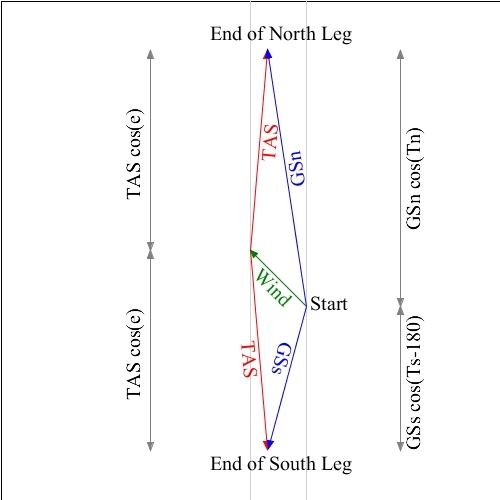
So I put together a diagram of the two velocity triangles, one for the Northbound leg, and one for the Southbound leg. The legs start at "Start", and finish at the marked leg-ends.
To establish each leg's end, we follow the green Wind vector, and then follow the red TAS vectors either "North" and "South", as determined by the compass.
Because we assume our compass has a N-S deviation, we see an error in the headings, which we can call 'e'.
The Ground Speed vectors just join the Start and end-points. We can call the GS and Track 'GSn' and 'Tn' on the Northern leg, and 'GSs' and 'Ts' on the Southern leg.
Using standard trigonometry I have marked some distances.
The first thing that hits me is that we have a good way of estimating the Northerly component of the Wind:
[ GSn cos(Tn) - GSs cos(Ts-180) ] / 2
The angles in those cosine terms should be quite small, which means the cosine terms are very nearly one, so this formula is really saying that the Northerly component of the wind is half the difference in the Ground Speeds, with small correction terms. Which makes sense.
We can fly East-West reciprocal legs to get the Easterly component of the wind from a similar calculation.
Now, armed with these two "cross-winds" we can work out the wind correction angle for each leg in the usual way. Subracting the wind correction angle from the GPS track gives us the actual heading for each leg.
Comparison of the actual heading to the compass heading gives the compass error.
The TAS estimate is the truly dodgy estimate in all this, but even a 10% error in our TAS estimate will only affect the wca by that same 10%, so with a modest wca, we should get quite an accurate result.
The other problem we face is wind varying with location and over time, but that should show up as non-symmetrical compass errors. If the errors appear to be symmetrical, we probably got lucky with the wind!
So in summary we fly North-South reciprocal legs, and East-West reciprocal legs, and use just GPS data to calculate the wind components.
Then we use those wind components and a rough estimate of the TAS to calculate wind correction angles.
These wind correction angles allows us to work back from the GPS tracks to get the actual headings, and so the compass errors.
I would be very interested to learn what the book method is!
I have the book in front of me at-last (I was in the middle of a move of my second office, and it was in the bottom of a box somewhere).
And, disappointingly, my memory was incorrect - whilst there's a perfectly good method in there for determining TAS and thus PEC, it doesn't cover determination of compass errors.
However, that's a trivial and minor setback. It just means that I'd have to do some maths myself.
Peter - if you still want to have a go, I'll work through the maths in such a way that I can drop a test plan out from it, and we can get together and have a go.
One of my "hobbies" (okay, it's good for my career as well) is writing and getting published research papers in various aspects of aeronautics: most usually they end up in Aeronautical Journal so I'd quite enjoy doing it just for an opportunity to get at the least a technical note out of it, and always happy to co-author these things.
G
Very kind of you to offer, Genghis.
However, I have been reading the SG102 installation manual and I don't see a way of doing it in the air. One needs a laptop connection to it, and also one has to do a "free field" measurement at the compass swing site, using a 50ft extension cable for the fluxgate module, which would be kind of fun doing in the air 
The SG102 then delivers the heading using ARINC429 label 320 to the two EHSIs, so there is no calibration to do there anymore.
However we can do the conventional (vertical card) compass swing in the air, as a proof of concept.
In many ways that makes for a better assessment of the method, as the calibration of the SG102 could be cross-checked against the calibration for the alcohol compass. On the other hand it makes it a bit more of an involved task; fun to do for me because I have a perverse and technical sense of fun and I'd enjoy doing it, but you might not.
I may have to go and just try it in my own aeroplane anyhow :)
G
No; I am more than happy to have a go. My plane is grounded from now, till just before Friedrichshafen (25th April) due to having removed the EDM700 for a rebuild into the larger version, and due to office holidays (staff shortage).
The last EHSI compass swing I did was done on the ground. That still used the KG102A+KMT112. All one did was to point the plane on each of the four cardinals and set the value (090, 180 etc) in the EHSI which then computed the correction in one go. Far simpler than swinging a normal compass which is an iterative process. But that could have been done in the air. I just got the bloke helping (an A&P/IA) to be really really careful with his compass.


