
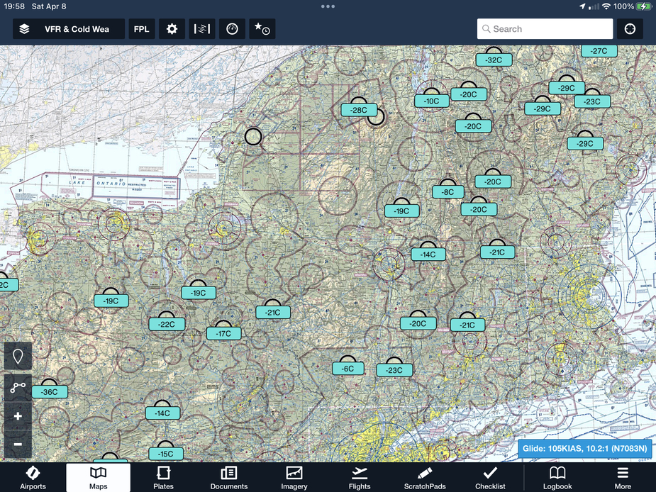
Here are some cold temperature airports I have plotted in the US NE. They are all colder than -7C down to -32C. None are at 0C.
There is a general point worth making (or discussing):
All enroute nav uses barometric altitude. This is fairly obvious because there is no way with GPS to fly an altitude (on QNH, or on 1013). The GPS navigator has no means of doing either.
Approaches can be flown with either baro (which is rare in GA avionics, and rarely published for airports) or GPS 3D guidance. LPV or +V is the latter. Or of course using the VS mode, D&D, etc, but there is no precision V guidance then.
So a transition needs to be made baro → GPS somewhere, and that point must be the FAF. To do it earlier would imply an altitude step, and you can’t do it later would be daft because you are tracking some vertical profile and the enroute altitude has been abandoned. And this will apply to nonprecision descents too; these are commenced at the FAF.
Peter wrote:
All enroute nav uses barometric altitude.
Correct.
Peter wrote:
This is fairly obvious because there is no way with GPS to fly an altitude (on QNH, or on 1013).
Primarily because what is called barometric altitude is in fact something else.
What any barometric altimeter does is indicate a vertical distance over a pressure level, assuming that the temperature profile between that level is ISA. So in fact the assumed distance over that pressure level is by far not always the same. The only thing which makes this tolerable is that everybody is “wrong” by the same amount (provided their altimeters are set on the same setting) so it is reasonably safe to keep people from banging into each other. That is particularly true in the flight levels, where everyone uses 1013.2 hpa.
However, using QNH and QFE has it’s ups and downs, literally. Quite a few accidents have happened due to erroneous settings.
Will the way go in the direction of using “geographical” altitude using GPS or similar systems one day? Quite possibly, but imho current technology is still quite a long way away from the accuracy needed to really go that way. But once it’s available and reliable, it may well change the altitude system in aviation and elsewhere profoundly.
When the procedure has a DA which implies it uses official vertical guidance as opposed to +V advisory vertical guidance, there isn’t really a FAF, it is called the PFAF because the GP dictates when one begins the descent from an MSL altitude to minimums on the FAC, and not when crossing the PFAF So the transition between Baro and GPS is at the GP intercept. In SBAS GPS navigators, the GP appears once the PFAF is the active fix. This is different than an ILS, where a GS is displayed when tuned and the receiver has adequate signal, which may be well outside the PFAF. In the US, one most abide by any step down fixes MSL minimum altitudes even if the GS /GP is displayed. This has caused some pilot deviations to be issued on long ILS approaches when the temperatures are well above ISA because although the ILS GS/SBAS GP is fixed in space. MSL altitude indication is lowered and thus one can be on the GS/GP and bust a minimum altitude.
Edit: note that if Baro VNAV is used (with the proper altimeter setting), the vertical guidance path varies with temperature, but as long as the Baro-VNAV is used for VNAV before the GS intercept, it won’t provide an indication below the GP. However, without temperature compensation, using Baro VNAV has upper and lower temperature limitations for an approach.
Also, GA systems with VNAV are based on Baro-VNAV but are not certified to use the Baro-VNAV capability for vertical guidance on the FAC. In theory, at least this is a capability that could be added and would support flying RNAV (aka RNP) LNAV/VNAV minimums when outside the SBAS SV or when SBAS VPL is not suited for vertical guidance on the approach. As it is today, all fail downs are to LNAV minimums without vertical guidance, but +V is available on many GPS navigators when outside the SBAS SV since an advisory +V provides a path as good or better than using DND method.
there isn’t really a FAF, it is called the PFAF because the GP dictates when one begins the descent from an MSL altitude
I remember it’s called FAP where GlidePath intercept intermediate segment for ILS, LPV and L/VNAV…on vectoring, the assigned altitude is not necessarily the one one the plates for FAF from LOC or LNAV
In the US, one most abide by any step down fixes MSL minimum altitudes even if the GS /GP is displayed.
Does that mean GlidePath are not protected on ILS after FAF (if one hits FAP before FAF of LOC)
So when are you suppose to descend if you get a higher altitude? after FAF to intercept from above?
I have been sent on Radar ILS twice once at 4000ft and once at 2000ft, the plates altitude says 3000ft, in both cases I made my descent when I intercept GlidePath without thinking about stepdowns, this seemed OK for ATC
What about vectored RNP with LPV annuniciation, should one just fly Glidepath?
Ibra wrote:
Does that mean GlidePath are not protected on ILS if one hits FAP before FAF of LOC?So when are you suppose to descend, after FAF to intercept from above?
GP/GS does not provide protection outside the PFAF except for the leg ending at the PFAF. Outside this, the minimum segment altitude provides obstacle clearance. As a practical matter, the GS/GP is a straight line in space and increases additional MSL altitude due to the curvature of the earth, so except in areas with mountains, the GS/GP will clear obstacles.
You are supposed to descend when cleared for the approach and the PFAF is the active fix and you are inside the previous fix. Normally the prefious fix is the IF. I will often not bother to descend to the intermediate leg minimum (I have seen posters on this forum refer to this as a platform altitude) and intercept the GP/GS by maintaining the previous altitude on crossing the IF, particularly if the difference is only 500 feet or so. The descent on a standard GP is approximately 300 feet/NM, so I would expect to intercept the GP approximately 1.7 NM outside the PFAF in this case. Most IF legs to the PFAF are 5 NM or more.
Ibra wrote:
I have been sent on Radar ILS twice once at 4000ft and once at 2000ft, the plates altitude says 3000ft, in both cases I made my descent when I intercept GlidePath without thinking about stepdowns, this seemed OK for ATCWhat about vectored RNP with LPV annuniciation, should one just fly Glidepath?
In the US, with a vector to final, ATC is responsible for terrain clearance until you are established on a charted segment of the approach. One may not be cleared below the altitude for the PFAF and should be from below the GS on a precision approach. So as long as the 2000 altitude was at or above the segment leading to the PFAF, US ATC could provide the vector. It could be below a step down altitude if above the MVA and if it crossed a step down altitude that allowed 2000 feet beyond it, ATC could specify something like: maintain 2000 until crossing [stepdown_fix_name], cleared ILS Rwy XX approach. Any clearance below a segment minimum altitude is now strictly prohibited. See https://reports.aviation-safety.net/2013/20130308-0_B190_N116AX.pdf which led to this prohibition.
From here
New Zeland and Australia now have RNP with L/VNAV minima using SBAS (and BARO) and yet they are outside SBAS SV volumes
I just did my DGAC-mandated PBN training. Oz and NZ use GBAS (G=ground), not SBAS, with correction coming from a local source on the airport itself. They have to, because there is no SBAS coverage down there and I guess it’s a lot cheaper to install GBAS at a relative handful of airliner airports than to launch an SBAS satellite.
You don’t need to launch your own satellite to get SBAS. You can rent a transponder on some commercial satellite. You need a monitoring station on the ground to send the correction data up to it.
Some stuff e.g. here.
Re temperature compensation, more e.g. here.
You are supposed to descend when cleared for the approach
Europe has almost totally gone away from that. You get cleared in steps, all the way to the IAP platform, before they say “cleared for IAPxxx”. I have seen exceptions but can’t remember where.
I just did my DGAC-mandated PBN training. Oz and NZ use GBAS (G=ground), not SBAS, with correction coming from a local source on the airport itself
I don’t think it’s GBAS? you can get L/VNAV and LNAV+V with raw GNSS in new navigators like GTN as long as you have plenty of NAVSTAR satellites (no SBAS signal), if the navigator can’t get L/VNAV due to VPL limits it will degrade to LNAV, if it can’t get LNAV it will show LOI
Only LPV require SBAS signal (EGNOS, WAAS, GAGAN, MSAS) and in Europe you also need some paperwork called Safety Of Life


