
NCYankee wrote:
The IFD will only annunciate L/VNAV when you are operating in an SBAS service volume with adequate HPL and VPL
How does IFD know about SBAS volume? or maybe there is tiny SBAS signal down in Sout-Asia (GAGAN or MSAS spillovers) but probably the quality of correction is weak as there are no local monitoring stations in Thailand?
See here,
https://ieeexplore.ieee.org/document/9183130
Can you stay within HPL & VPL tolerances for LNAV/VNAV outside SBAS volumes?
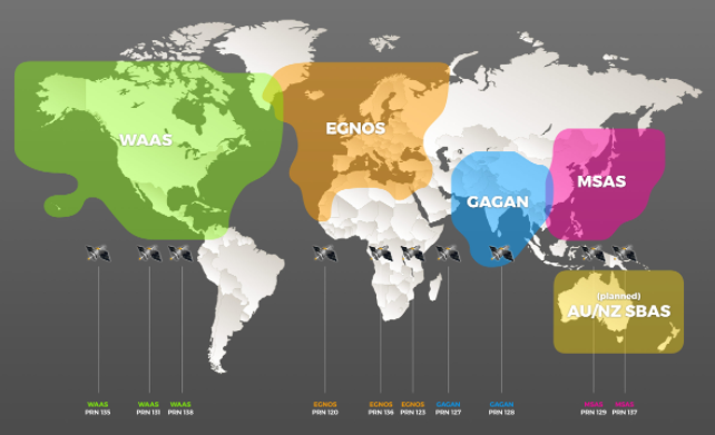
There is “SBAS” in lots of places but – some previous threads on this – I’ve never come across anybody who knows which SBAS satellites are supported by Garmin or Avidyne navigators… apart from obviously the US WAAS ans European EGNOS satellites.
I have recently spent a lot of time on software converting data from a U-BLOX consumer GPS to ARINC429 (see around here) so became quite familiar with this, but certified avionics are something else…
But if you can get +V without SBAS, it doesn’t really matter. SBAS does really very little for GPS accuracy. It does more for integrity than for accuracy.
Peter wrote:
I’ve never come across anybody who knows which SBAS satellites are supported by Garmin or Avidyne navigators
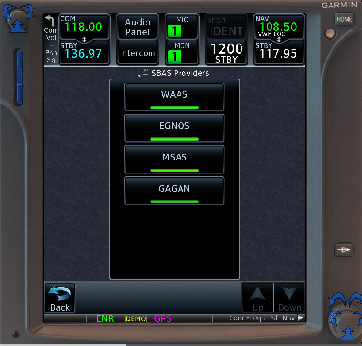
The Pilot’s Guide for the GTN Xi series states that it supports EGNOS, GAGAN, MSAS and WAAS.
Interesting. This suggests that eal may be out of luck, but as I say he probably doesn’t need it
Those may be footprints for SBAS, but not for the SV that includes LNAV/VNAV and LPV level of service. To get LNAV/VNAV level of service, you need to have HPL 556 meters or better (rarely ever an issue) and VPL to be 50 meters or better. So in the WAAS SV, Hawaii is covered as is Puerto Rico, but neither has LNAV/VNAV VPL level of service. There are some LNAV/VNAV in Puerto Rico, for example TJSJ RNAV (GPS) Rwy 10 has an LNAV/VNAV option, but the chart says “WAAS VNAV NA”. Hawaii also has RNAV (GPS) approaches that provide LNAV/VNAV minimums, example PHJO RNAV (GPS) Rwy 35, but it also has the note “WAAS VNAV NA”. With the Garmin GTN series and the Avidyne IFD series, they provide +V advisory vertical navigation for LNAV in Hawaii and Puerto Rico and you can even disable SBAS and still get the LNAV+V.
Note that the VPL of 50 meters or better is also required for LPV for a DH >= 250 feet. LPV200 requires VPL be 35 Meters or less.
eal wrote:
Currently using my GNS on the LNAV/VNAV approaches out here l get a downgraded LNAV as you describe, but reading the response from Garmin, it appears the newer software on the GTN does provide the +V in a non SBAS environment. Or at least that is how l am reading it. So presumably this is a feature they have enabled recently on GTN’s only?I am currently hoping/ assuming the IFD’s behave the same way as the GTN.
Both are certified to the latest version of the TSO which provides +V outside an SBAS SV.
Ibra wrote:
How does IFD know about SBAS volume? or maybe there is tiny SBAS signal down in Sout-Asia (GAGAN or MSAS spillovers) but probably the quality of correction is weak as there are no local monitoring stations in Thailand?
There don’t need to be monitoring stations as long as the GAGAN or MSAS can provide the required VPL. The navigator knows if it is in an SBAS service volume and the integrity is also broadcast by the SBAS satellites. Of course the more monitoring stations, the better integrity values can be assured. I know that the Garmin units also allow the pilot to configure which SBAS system is being processed.
Peter wrote:
There is “SBAS” in lots of places but – some previous threads on this – I’ve never come across anybody who knows which SBAS satellites are supported by Garmin or Avidyne navigators… apart from obviously the US WAAS ans European EGNOS satellites.
These are the ones listed by the GTN system. You can select all or whichever one you wish to use. There are some areas of overlap.
All the GPS based SBAS systems are standardized, they all use the US GPS system. The PRN for the SBAS are in an assigned group in addition to the 32 GPS satellites and they are geostationary. There is no technical reason why an SBAS enabled navigator would not support any compliant provider.
eal wrote:
There is definitely a difference in the IFD terminal mode annunciator. LNAV only approaches show GPS→LNAV+V as it transitions, whereas LNAV/VNAV show as GPS→LNAV/VNAV. I would have thought if the RNP integrity for supporting VNAV was not met, the IFD would automatically downgrade the approach? Otherwise this would be very misleading.
The difference in minima between the two can be as much as several hundred feet.
Then you must be operating in an SBAS service volume with adequate VPL to get LNAV/VNAV annunciation.
All the GPS based SBAS systems are standardized, they all use the US GPS system
There are differences though. For example the US WAAS satellites also do positioning, whereas the European EGNOS satellites don’t.


