Supersonic wrote:
That confuses me: how do you establish the correlation of cloud coverage and ceiling?
Yes it’s not one-to-one, “ceiling height” is different from “cloudbase height” and different from “average cloud % amount in 0ft-6kft volume”, but the 3 are linked?
Only TAF & METAR will give you ceiling, AFAIK there is no information on en-route ceiling? only cloud-base is available…
It’s useful info I cruised at 4000ft in VMC with 1200ft cloudbase on METAR when Windy showed very low cloud amounts bellow 6000ft
Also useful for IMC flying while crossing icing band, you don’t pick up that much on climb if “gaps are around” or “clouds are not tick”
Obviously, if you get it wrong above cloud base you will be flying IFR 
Ibra wrote:
AFAIK, only TAF & METAR will give you “ceiling” there is no information on the ceiling when flying en-route? only cloud-base is available?
Hm. In the Meteogram there is a line which says “Wolkenuntergrenze” which is “cloud base”. However, the diagram shows some clouds before 12h although no cloud base indication is given. Maybe just the translation is wrong and it should be “cloud ceiling”: “Hauptwolkenuntergrenze”.
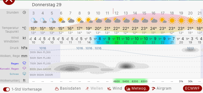
On recent ECMWF model run from last 6h, I am sure the realized actual ceilings on METAR are usually higher than those forcasted model values, I have seen this in more flights that I can count !
I guess they refer to cloud-base (dew = temp & SCT, FEW) rather than ceiling (BKN, OVC), still a good thing nonethless, usually you plan for on worst forcast and end up flying in better actual
Ibra wrote:
I guess they refer to cloud-base (dew = temp & SCT, FEW) rather than ceiling (BKN, OVC), still a good thing nonethless, usually you plan for on worst forcast and end up flying in better actual
Yes, probably. From my (VFR) experience the cloud base and rough density indication derived from those diagrams is not so bad after all.
Supersonic wrote:
Which weather model do you use in Windy? ICON-EU comes from DWD, I guess.
Windy.com somehow prefers the ECMWF. But this model looks to me very optimistic, showing too few clouds. ICON-EU looks a lot more detailled, and I think it always shows more clouds.
It is true, that to some part it’s not the fault of Windy, but the underlying weather model. However, the weather model does not show clouds, but Windy calculates clouds out of expected solar insolation, wind, temperature, humidity distribution (where dew point and saturation can be derived from) and so on.
So for example forecast for next Saturday, which is in two days:
ECMWF

And same for ICON-EU:
![]()
So based on only the ECMWF picture I’d say I’d fly easily from Biarritz to Asturias along the spanish north atlantic coast. But the ICON-EU picture tells another story…
What Windy does, is, that they show a picture with a high detailled cloud distribution, even showing that the very coastline will be free of clouds, and so on, but it’s in fact totally unreliable.
Windy’s ‘flight planner’ (not the default one) plugin supports *.flightplan files from SkyDemon:
https://www.windy.com/plugins/windy-plugin-fp
It shows vertical atmosphere cut based on ECMWF weather model:
https://postimg.cc/HJJt9LPK
Is anyone else using Windy for the above? It looks impressive. One thing they are not trying to do, it seems, is depict IMC vertically like a GRAMET. It would be useful to get a GRAMET from the ECMWF model. GFS and ICON are unreliable.
The only thing that I cant seem to get to show on Windy and that I really would like to see is Front lines…
Otherwise I think its great, especially the option to chose the forecast model and the expected cloud base function.
They’re about to add a GPS position into the website and app, so we could have a poor-mans weather radar 🙂 I know, it’s data isn’t accurate and delayed, but it’s better than nothing at all, in case if you have to divert. SD also has the ability to show weather forecast (rainfall), but cross-checking between the two will only benefit your awareness.
I would really appreciate if you take your time and spend 5 minutes on the registration process on their forum by and leave a reply in this thread:
https://community.windy.com/topic/11876/gps-boat-position/11?_=1634131612479
I just found another worth mentioning weather website:
https://meteo.imgw.pl/dyn/#group=nowcasting¶m=prec-0-sfc&loc=52.45602817813499,13.403451480083397,6
It runs SCENE/INCA 1km resolution 8hr forecast model and it may be used as an extension for Windy’s AROME 1.2km for Poland, Czechia and Slovakia: