Peter wrote:
It will probably come, but probably not before the UK manages to save up enough money to launch some EGNOS sats
Airliners will probably go GBAS… Allegedly GBAS is better than ILS CAT 3 in the future (aircraft can be positioned next to runway as it does not block ILS signal).
So yes, the most screwed category is GA and as @Graham pointed previously, we don’t count.
The thing is, every technology comes with a certain logic.
The LPV logic is :
Also, many airports have one ILS, but LPV provides lower minima to the other runways.
Thanks NCYankee for this paper. It is meant to show the good sides of LPV but provides good info :
LPV coming to an end in the UK:
C5661/21: Exeter: Global Navigation Satellite Systems not available
Q) EGTT/QGAAU/I/NBO/A/000/999/5044N00325W005
LPV LINES OF OCA(H) DISPLAYED ON THE RNP INSTRUMENT
APPROACH CHARTS ARE NOT AVAILABLE FOR USE.
FROM: 25 Jun 2021 00:01 GMT (01:01 BST)
TO: 24 Sep 2021 23:59 GMT (25 Sep 00:59 BST)
C5660/21: Newcastle: Global Navigation Satellite Systems not available
Q) EGPX/QGAAU/I/NBO/A/000/999/5502N00141W005
LPV LINES OF OCA(H) DISPLAYED ON THE RNP INSTRUMENT
APPROACH CHARTS ARE NOT AVAILABLE FOR USE.
FROM: 25 Jun 2021 00:01 GMT (01:01 BST)
TO: 24 Sep 2021 23:59 GMT (25 Sep 00:59 BST)
408) Posted 18 Jun 2021 04:20 GMT (05:20 BST)
C5659/21: Humberside: Global Navigation Satellite Systems not available
Q) EGTT/QGAAU/I/NBO/A/000/999/5334N00021W005
C5658/21: Southampton: Global Navigation Satellite Systems not available
Q) EGTT/QGAAU/I/NBO/A/000/999/5057N00121W005
LPV LINES OF OCA(H) DISPLAYED ON THE RNP INSTRUMENT
APPROACH CHARTS ARE NOT AVAILABLE FOR USE.
FROM: 25 Jun 2021 00:01 GMT (01:01 BST)
TO: 24 Sep 2021 23:59 GMT (25 Sep 00:59 BST)
C5657/21: Bristol: Global Navigation Satellite Systems not available
Q) EGTT/QGAAU/I/NBO/A/000/999/5123N00243W005
LPV LINES OF OCA(H) DISPLAYED ON THE RNP INSTRUMENT
APPROACH CHARTS ARE NOT AVAILABLE FOR USE.
FROM: 25 Jun 2021 00:01 GMT (01:01 BST)
TO: 24 Sep 2021 23:59 GMT (25 Sep 00:59 BST)
C5656/21: Cardiff: Global Navigation Satellite Systems not available
Q) EGTT/QGAAU/I/NBO/A/000/999/5124N00321W005
LPV LINES OF OCA(H) DISPLAYED ON THE RNP INSTRUMENT
APPROACH CHARTS ARE NOT AVAILABLE FOR USE.
FROM: 25 Jun 2021 00:01 GMT (01:01 BST)
TO: 24 Sep 2021 23:59 GMT (25 Sep 00:59 BST)
C5655/21: Doncaster Sheffield: Global Navigation Satellite Systems not available
Q) EGTT/QGAAU/I/NBO/A/000/999/5329N00100W005
LPV LINES OF OCA(H) DISPLAYED ON THE RNP INSTRUMENT
APPROACH CHARTS ARE NOT AVAILABLE FOR USE.
FROM: 25 Jun 2021 00:01 GMT (01:01 BST)
TO: 24 Sep 2021 23:59 GMT (25 Sep 00:59 BST)
A2033/21: Prestwick: Global Navigation Satellite Systems not available
Q) EGPX/QGAAU/I/NBO/A/000/999/5531N00436W005
LPV LINES OF OCA(H) DISPLAYED ON THE RNP INSTRUMENT
APPROACH CHARTS ARE NOT AVAILABLE FOR USE.
FROM: 25 Jun 2021 00:01 GMT (01:01 BST)
TO: 24 Sep 2021 23:59 GMT (25 Sep 00:59 BST)
A2032/21: Sumburgh: Global Navigation Satellite Systems not available
Q) EGPX/QGAAU/I/NBO/A/000/999/5953N00118W005
LPV LINES OF OCA(H) DISPLAYED ON THE RNP INSTRUMENT
APPROACH CHARTS ARE NOT AVAILABLE FOR USE.
FROM: 25 Jun 2021 00:01 GMT (01:01 BST)
TO: 24 Sep 2021 23:59 GMT (25 Sep 00:59 BST)
B1413/21: not available
Q) EGXX/QGWAU/IV/NBO/E/000/999/5504N00500W999
THE EUROPEAN GEOSTATIONARY NAVIGATION OVERLAY SERVICE (EGNOS) IS
NOT AVAILABLE FOR LPV PROCEDURES. LPV LINES OF OCA(H) DISPLAYED ON
RNP INSTRUMENT APPROACH CHARTS ARE NOT AVAILABLE FOR USE.
FROM: 25 Jun 2021 00:01 GMT (01:01 BST)
TO: 24 Sep 2021 23:59 GMT (25 Sep 00:59 BST)
I didn’t know the UK had that many 
Fortunately most/all of these have an ILS.
Still no credible story has come out anywhere on the background to this.
In the above PDF is this bit of news:
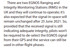
which is really interesting. Why would the UK continue to pay for these stations? The only benefit to the “UK” is for the Channel Islands. However, once the decision has been made to continue funding this, then UK could set up its own SBAS signal by renting a transponder on a geostationary satellite. IR the UK CAA could just not issue these pointless notams, because the signal is not going away…
Peter wrote:
However, once the decision has been made to continue funding this, then UK could set up its own SBAS signal by renting a transponder on a geostationary satellite. IR the UK CAA could just not issue these pointless notams, because the signal is not going away…
The SBAS addition is a piggy back system that has to be included in the satellite package and is not a simple standard transponder rental. The value of SBAS corrections for a few GRT is not going to provide suitable corrections to support LPV and is a waste of money. It would make more sense to wait on dual frequency L1/L5 and not depend on SBAS, but this will require new GPS receivers. GLS also does not have any dependence on SBAS as it relies on GBAS. So the main impact is to GA, which from what does not sound like it is a priority.
NCYankee wrote:
The SBAS addition is a piggy back system that has to be included in the satellite package and is not a simple standard transponder rental.
Which means that it is a separate piece of equipment installed in the satellite and so must be present at launch. It is not just a matter of configuring a transponder on a satellite already in orbit.
It would take several years for the UK to get its own SBAS capability even if they decide to use a commercial satellite.
I wonder if the 3 month notam duration is just right to prevent Jepp dropping the IAPs from their databases?
The current name for gps approaches, RNP seems to cover lpv, rnav+v,rnav/vnav etc ALL on one plate….so will the only difference be the removal/notam of the lpv minima?
I think you need to check RAIM for any RNP approach except for the LPV approach. If the LPV approach is unavailable for some reason you need to revert to checking RAIM and using the LNAV minima. You do not have any certified vertical guidance . I think @NCYankee explained this in previous posts.
Peter wrote:
I wonder if the 3 month notam duration is just right to prevent Jepp dropping the IAPs from their databases?
AFAIK, 3 months is the maximum time for a NOTAM.
RAIM check not necessary for rnav(depending on avionics) but, answering my own question, the lpv sensitivity is different from rnav so lpv approach selected is different in avionics but not plate.