
Question to the GNS430 pilots who substitute the DME with GPS.
I have switched off CROSSFILL to be able to use GPS2 for DME purposes while I have the Flightplan including the ILS in GPS1.
Now I plan to fly to Erfurt (EDDE), and the ILS28 Approach uses two different DMEs for the Apprach. First it’s “ERF” for the procedure turn to the Localizer, and then it’s “EFD” for the Final’s Altitude and Distance Checks and for the Missed Approach.
Is it a good idea to put BOTH ERF and EFD into a flight plan in GPS2 two and then simply open the FPL, select the one I need and use DCT? Or is there a better way to do it?
How do you do it?
I would not substitute the DME with GPS on an approach. We have discussed this some days ago. Chances are just too high that you use the wrong GPS database item and there are nasty things like DMEs with offsets.
Setup your GPS2 to run the RNAV approach (or the GPS ILS overlay actually). Once you are established on the final approach, it will show distance to the threshold. This number is pictured on your Jeppesen chart next to each DME based distance. Just compare this number in addition to your DME.
Yes, that’s another way, but then I don’t have the DME check altitudes. Okay, with the LIVE approach chart I can really see when i overfly those points ..
How about the missed approach? I do need the DME distance for that.
I would calculate the ATD (Along Track Distance) and use these values from the approach. Assuming you are being vectored to final, the GNS430 will show two waypoints, one (FI28) at EFD 4.7 (4.1 NM from the threshold) and one (RW28) at the threshold. So when FI28 is the active waypoint, you can identify EFD D9.8 (5.1 ATD) and EFD D7.0 (ATD 2.3) by their ATD to FI28. When you show RW28 as the active fix, EFD D1.2 is at ATD 0.6.
Yes, that’s another way, but then I don’t have the DME check altitudes.
You do, have a look at the Jeppesen chart. For every check altitude, it will give you the distance to threshold
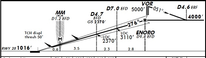
When you have the 2nd GNS430 in GPS mode and the approach loaded (ILS 28 EDDE), it will give you a warning first that it’s only for situational awareness and once you are established and beyond the FAF, it will show distance to threshold in NM. At your check altitude 2370 which is D4.7 EFD, you can see at the bottom that it is 3.5 NM from the MM which is 0.6 from the displaced threshold. Employing your math skills, you arrive at 3.5 + 0.6 = 4.1 NM. Therefore when GPS2 shows 4.1 NM to THR, you should be at altitude 2370ft.
Okay, with the LIVE approach chart I can really see when i overfly those points ..
Those “points” are not in the GNS430 chart, only if you have an MFD with Jeppesen charts but that is not really supposed to be used for your approach.
How about the missed approach? I do need the DME distance for that.
For the missed approach, I would just fly the GPS overlay. It’s a much less critical part of the flight, especially in the case of EDDE with a benign obstacle situation.
However, the question remains: why on earth would you want to do this? You do have a DME and you should not substitute it for GPS when there is no pressing need. I personally turn off my DME enroute and only use the GPS but I turn it on for the approach and use it together with the GPS. I trust a DME much less than a GPS so I use both to spot any discrepancies (yes, I’ve had the DME display a too large number in the past). For this, your GNS430 contains every approach as a GPS overlay.
Please don’t substitute DMEs with GPS on approaches as a general thing. You can get yourself killed this way and there is no need to do it. DMEs are legally required for all IFR flights in Germany and other European countries. You have one, so use it.
Thank you. Math skills? I don’t have any math skills ;-)
I’ll try both methods today, DME stations in the GPS – and yours
Those “points” are not in the GNS430 chart, only if you have an MFD with Jeppesen charts but that is not really supposed to be used for your approach.
Of course I have it on the MFD, and of course i USE it for the approach. What else should I use it for (Yes, I know the official wording)
If you have DME what would you not just use it??
(Yes, I would use it :-))
Good morning!
There is only one official answer to this question:
If you look at the smallprint of the Jeppesen Chart for the ILS Approach 28 at EDDE (Chart 12-2, issue date 1 JUN 12) it says in bold typeface: “DME required”. Without DME, you can not fly this approach. (Well, you can, but you are not allowed to and it may be unsafe.) You would have to fly the RNAV-GPS approach instead, which is also a published and official procedure.
Distance coding in ILS-approaches (either via DME, GPS, marker beacons, locator beacons or cross radials) serves the purpose of making sure to have intercepted the correct glideslope signal (and not a sidelobe) and to verify that your glideslope indication is valid. Without distance checks (or with selfmade ones) you take away the only safety net built into an approach, that will take you down to 200ft above the ground (or even 140ft if your altimeter has the maximum permissible error!). A lot of people get away with it, but quite a few have flown themselves into the ground or into hillsides.
Happy landings
max
I’ve had the DME display a too large number in the past
Which DME receiver do you have and where did you see the large number?
Some DME receivers are apparently susceptible to lock to a reflected version of the signal in mountaineous terrain


