I don’t plan altitudes for VFR either, other than a general idea of what will be required. I mostly plan airspaces and then I just fly while looking outside and figuring out my desired altitude.
I was never taught VFR cross country flying by figuring out the MSA altitude and use it. I was taught to identify terrain marks and follow those while keeping the minimum altitudes and distances.
What I was taught by experienced “VIFR” flyers before I got my IR was to always keep the MSA available (easy with Garmin yoke mounts) and when weather becomes a problem use the AP to climb to MSA instead of going lower and lower. This was the first time when MSA become a factor in my VFR flying considerations.
I wasn’t thought to fly at IFR levels for VFR either. It certainly wouldn’t have been possible here, as due to the proximity of the Dublin mountains we’d have two problems.
1. The minimum possible altitude would put it into airspace controlled by Dublin Airport, and they aren’t very accommodating unless you have a real need to be in there.
2. The cloud base would mean that a large percentage of days would not be flyable.
However we were thought to calculate this safety altitude and to note it down for each leg on our route. This was if we messed up and found ourselves in cloud, we know exactly what altitude we had to climb to, to be safe from obstacles.
But the planned altitude was almost always much lower than this safety altitude.
In the US, airspace is much simpler, with most airspace being Class E. So avoiding Class B and C airspace is relatively easy. VFR pilots still have to worry about avoiding restricted, prohibited, and TFR airspace and to be aware of Class D airspace. Weather plays a role in the altitude selection as well, but for most of the US, the major consideration is performance, winds, and turbulence. If low level flight is desired, we have excellent government provided VFR sectional charts that show terrain, visual features, airports, and airspace.
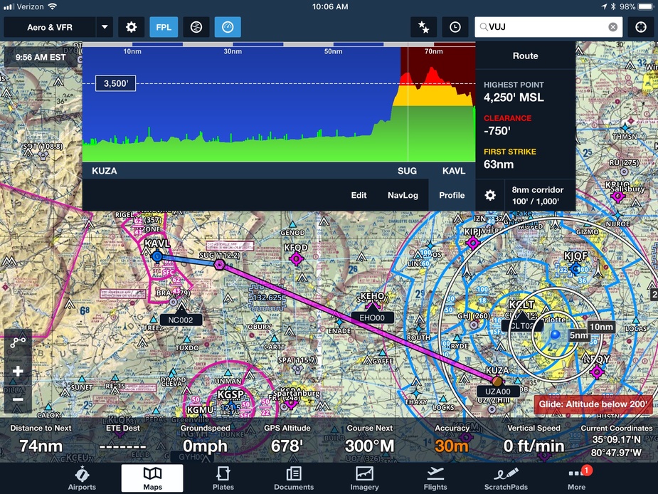
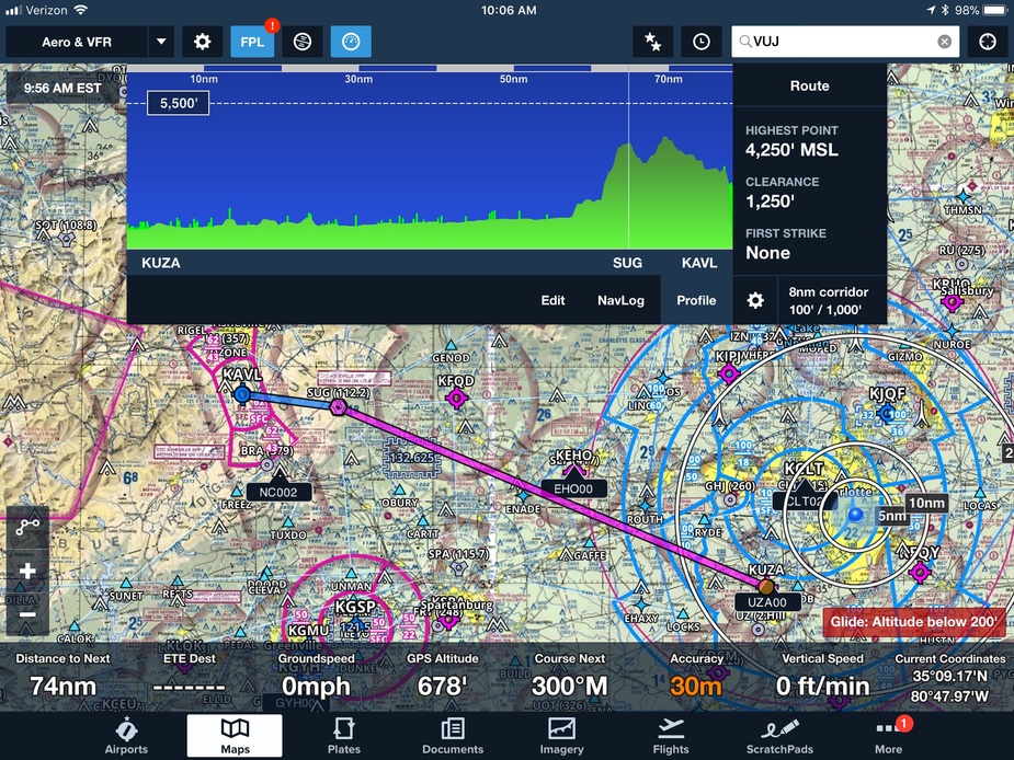
With ForeFlight, there is a feature to allow the pilot to specify the corridor total course width for terrain and obstacles and a profile view of the flight path that shows graphically the AGL clearance along a given route, the highest point, and where you will first strike the terrain or obstacle. The pilot can set the flight altitude level by sliding the altitude up or down and see the clearance. Terrain depicted below the altitude is red, and within 1000 feet are yellow, and above 1000 AGL are green. I personally set the course width to 8 NM (that is for IFR +/- 4 NM). Other settings are pilot selectable for Corridor Total Width of 0.5 1, 2, 4, 8, and 20 NM.
NCYankee wrote:
In the US, airspace is much simpler, with most airspace being Class E.
Certainly not simpler than in Germany. The airspace layout in those two countries is extremely similar.
In the US, airspace is much simpler, with most airspace being Class E. So avoiding Class B and C airspace is relatively easy
Very much so compared to most of Europe, plus the other big benefit you have in the USA is an assured transit of most CAS on two-way radio contact.
However we were thought to calculate this safety altitude and to note it down for each leg on our route.
Exactly the same here.
This was if we messed up and found ourselves in cloud, we know exactly what altitude we had to climb to, to be safe from obstacles.
I can’t say whether this was the reason here but you don’t need to be in cloud to hit something. You could be flying in rain, and the poor forward vis could cause you to not see e.g. a TV mast. There are a lot of tall masts around. And on a clear night there can be so many lights all over the field of view (if flying over a built-up area) that the light on top of some 1000ft+ high mast might not be noticed.
On reality I guess few people follow the planned MSA and indeed it is difficult to follow it strictly under the 2500ft LTMA. This is even better:
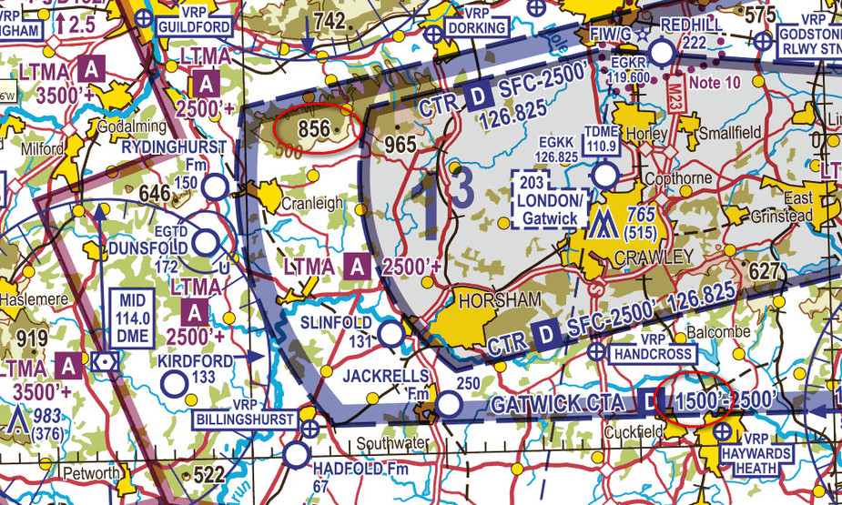
You should plan for 1900ft but the CAS base is 1500ft.
VFR Altitude planning for me is to decide low or high only. I am not looking at grid MSA – this is overkill for good weather day VFR. And in case of lower ceiling/ bad weather? MSA will not help, flying at MSA put you in clouds. So you need to consider terrain carefully, not to relly on grid MSA.
I tried to add these to my post, but must have been too late:
I think VFR flight planning should focus on local circumstances. During my training all flights were planned 2000 ft AMSL (not AGL!) and in a straight line from A to B. No exceptions. If in-flight we found 2000 ft to be too bumpy, we climbed. If the ceiling was lower, we stayed below the ceiling.
Would such an approach be wise in a mountainous area? No, it would be suicide. But in the north German plains it is physically impossible to hit anything at 2000 ft AMSL, and airspace is wide open (class E) except for a few smallish CTRs around military bases and the three international airports of EDDV, EDDW and EDDH. So this simple approach works perfectly and is safe. Wouldn’t want to do this 100 NM to the south though.
During my training all flights were planned 2000 ft AMSL (not AGL!) and in a straight line from A to B. No exceptions
That sounds awfully like my PPL training in 2000/2001 
Since 1999 I’ve been flying an aircraft with no attitude indicator of any kind, (there is a turn-and-slip) and only a magnetic compass, wobbly in turbulence. I stay below cloud, and choose the valley to avoid major shower activity.
Going into IMC would be suicide, unless very low and able to put on the ground.
As I don’t want to put the Jodel out of action, I don’t go near any weather that would lead to that.