From here
Peter wrote:
There is no unified VFR chart which covers “Europe”
Coverage expanding very quickly.
Some way to go
and no spot elevations on the one I downloaded.
Open source is not going to work, due to the amount of effort monitoring the AIPs etc. They will have to go commercial, to pay someone to do the job.
They are open but they have sources of revenue.
They’re doing better than most others, their maps are up to date and correct. In my view, open source is the way to go.
Some way to go
A very negative way of looking at things. Soon there will be Greece making it the first ever complete VFR chart for Greece. Contributed by a Greek ATCO from what I gathered.
I would like to add another source for free VFR and IFR charts: www.milais.org (available in German and English)
The site is run by the German Zentrum Luftoperationen (ZLO/ Air Operations Center) and provides not only the German milAIP for free, but also visual approach charts for all military and quite a few civil aerodromes both large (e.g Tegel EDDT) and rather small (e.g. Speyer EDRY) in Germany.
These can be found via Library > Publications > GEMIL FLIP VAD
Additionally, you can find instrument approach charts for the mentioned German aerodromes (where applicable) plus a few European ones when selecting Library > Publications > CENOR FLIP or CENOR FLIP by country
All publications are provided in PDF format with a clear indication of the effective date.
You can also find some information about special activity areas like air refueling anchors or TRAs under the option GEMIL FLIP MAP, just in case you are interested.
Personally, I like these charts very much, although they look quite differently from the Jeppesen or DFS charts one might be used to. They of course have some info we cannot use, for example the allocated UHF frequencies, but also some very good bits like coordinates of VFR reporting points both in lat/long and UTM attached to each VAD chart.
I hope this was helpful to some of you :)
Edited for typos.
Schönen Dank, @CR!
Many thanks for posting this, @CharlieRomeo
This is interesting. AIUI the whole VFR section of the German AIP is behind the paywall and has been since “for ever”. It comes “free” with some products e.g. Jeppview (and its tablet versions) and Jepp MFDVFR includes it.
But on that site I can find for example this which should not be in the free German AIP 
So this looks like a great resource!
Many are missing e.g. Dortmund EDLW. I downloaded the entire GAMIL FLIP VAD (182MB) and it’s not in there either.
These charts are made and published by the German military, and thus don’t belong to the DFS at all. Their design and the underlying background map are completely different, so the DFS has no say in that.
Unfortunately, as you noticed, not all civilian airports/airfields are included. I did not notice a rule regarding which are and which are not- maybe one of you will discover one.
The only difference between the “GEMIL FLIP VAD complete edition” and the other files is that the former is a huge file with all charts, whereas the other option lets you download single airfield charts. Sorry I did not make that clear.
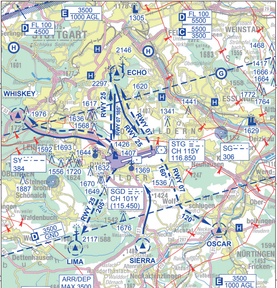
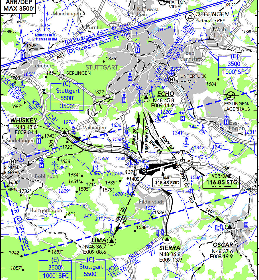
Interesting… I have no access to the German VFR AIP so cannot compare e.g. the above VFR chart to the AIP one for EDDS. I have Jepp access but those are re-drafted by Jepp…
Mil:
Jepp:
The 180MB PDF would have been great if they implemented bookmarks 
achimha wrote:
Peter wrote:
There is no unified VFR chart which covers “Europe”
http://www.openflightmaps.org
Coverage expanding very quickly.
Just had a look at the Denmark chart. I am not quite sure what to make of it. On one hand it looks very ambitious, on the other some useful data are missing (obstacles probably being the most important), some names are misplaced, it seems random which airports and airfields have frequencies assigned to them and which ones have not, and one former public airfield is shown although it has not been there for 10+ years. Some smaller fields are not shown although they are in the AIP. With the DK ICAO VFR chart being available as Albin explained (and useful as a digital chart with georeferencing), I would prefer that one, but for other countries, I guess this kind of map could be very useful if you are aware of its limitations, especially lack of information on obstacles.
The German AIS Centre will email you the pages of the VFR AIP that you need if you phone them, with an admonition not to share them. The phone number is on https://secais.dfs.de/pilotservice/home.jsp?lang=en .
Make sure you request charts and text pages, and call back if they send only charts. Some aerodromes don’t have text pages, then you should get/have the relevant page(s) of the “List of Aerodromes” section (pages AD2-1 to approx AD2-114).
Before I got Jeppesen anyway for my IFR training, I would call them before each flight, telling them, as appropriate, for each of my destination, destination alternate, enroute alternate, etc:
And once or twice per year, I would request the whole of AD1 and the AD2 “List of Aerodromes”. In particular, AD1 contains the noise abatement rules that aerodromes pages just refer to without spelling them out again.
They are also very helpful if you have a question about aviation law in Germany; after the introduction of SERA, some instructors insisted that the “old” German rules for NVFR were still in place (something like must file a route along IFR airways / waypoints / …), but I found no basis for it in the AIP. I called the AIS-C, and got confirmation that SERA abolished all these things. Also, it wasn’t clear to me whether the “Nachttiefflugstrecken” on the VFR maps were “Recommended but not mandatory NVFR corridors for our use”. Turns out they are “That’s where the military are flying fast and low at night. Avoid that area at that altitude.”